Argelos, Pyrénées-Atlantiques
| Argelos | |
|---|---|
|
Argelos | |
 Argelos | |
|
Location within Nouvelle-Aquitaine region  Argelos | |
| Coordinates: 43°27′09″N 0°20′47″W / 43.4525°N 0.3464°WCoordinates: 43°27′09″N 0°20′47″W / 43.4525°N 0.3464°W | |
| Country | France |
| Region | Nouvelle-Aquitaine |
| Department | Pyrénées-Atlantiques |
| Arrondissement | Pau |
| Canton | Thèze |
| Intercommunality | Luys en Béarn |
| Government | |
| • Mayor (2014–2020) | Marcel Borny |
| Area1 | 6.01 km2 (2.32 sq mi) |
| Population (2009)2 | 264 |
| • Density | 44/km2 (110/sq mi) |
| Time zone | CET (UTC+1) |
| • Summer (DST) | CEST (UTC+2) |
| INSEE/Postal code | 64043 / 64450 |
| Elevation |
142–264 m (466–866 ft) (avg. 158 m or 518 ft) |
|
1 French Land Register data, which excludes lakes, ponds, glaciers > 1 km² (0.386 sq mi or 247 acres) and river estuaries. 2 Population without double counting: residents of multiple communes (e.g., students and military personnel) only counted once. | |
_vue_1.JPG)
Argelos (Argelòs in Occitan) is a French commune in the Pyrénées-Atlantiques department in the Nouvelle-Aquitaine region of south-western France.
Geography
_vue_2.JPG)
.JPG)
.JPG)
Argelos is located some 25 km north of Pau and 3 km west of Auriac. Access to the commune is by the D214 road from the village north to join the D944 road south-east of Thèze. The A65 autoroute passes through the northern tip of the commune but the nearest exit is Exit 9 near Miossens-Lanusse.[1] The commune is mixed farmland and forest.
Located in the Drainage basin of the Adour, the Luy de France forms the north-eastern border of the commune as it flows north-west fed by its tributaries the Basta and the Balaing.
Places and Hamlets
Neighbouring communes and villages
 |
Viven | Thèze | Miossens-Lanusse | |
| Doumy | |
Auriac | ||
| ||||
| | ||||
| Bournos | Navailles-Angos | Lasclaveries |
Toponymy
The commune name in béarnais is Argelos. Brigitte Jobbé-Duval[6] indicated that Argelos probably had a latin origin of argilla (meaning "Clay") with the suffix -ossum. The meaning of the name would then be "clay soil".
The following table details the origins of the commune name and other names in the commune.
| Name | Spelling | Date | Source | Page | Origin | Description |
|---|---|---|---|---|---|---|
| Argelos | Argilos | 1214 | Raymond | Chapter of Argelos | Village | |
| Argelos | 1750 | Cassini | ||||
| Bernès | Bernet | 1385 | Raymond | Census | Farm |
Sources:
- Raymond: Topographic Dictionary of the Department of Basses-Pyrenees, 1863, on the page numbers indicated in the table. (French)[7]
- Cassini: Cassini Map from 1750[8]
Origins:
- Census: Census of Béarn[9]
History
Paul Raymond noted on page 10 of his 1863 dictionary that in 1385 there were 29 fires in Argelos and it depended on the bailiwick of Pau. Auriac was formerly annexed to the commune.[7]
The barony[7] of Viven included Argelos, Auriac, and Viven and was a vassal of the Viscounts of Béarn.
Administration
List of Successive Mayors[10]
| From | To | Name | Party | Position |
|---|---|---|---|---|
| 1995 | 2014 | Hélène Peyras | ||
| 2014 | 2020 | Marcel Borny |
(Not all data is known)
Intercommunality
Argelos is part of 4 inter-communal structures:
- the Community of communes of Luys en Béarn;
- the AEP association of the regions of Luy and Gabas;
- the Energy association of Pyrénées-Atlantiques ;
- the scholastic association Argelos - Astis.
Demography
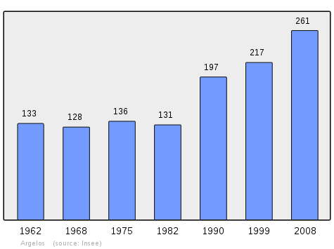
In 2009 the commune had 264 inhabitants. The evolution of the number of inhabitants is known from the population censuses conducted in the commune since 1793. From the 21st century, a census of communes with fewer than 10,000 inhabitants is held every five years, unlike larger towns that have a sample survey every year.[Note 1]
| 1793 | 1800 | 1806 | 1821 | 1831 | 1836 | 1841 | 1846 | 1851 |
|---|---|---|---|---|---|---|---|---|
| 325 | 533 | 414 | 357 | 361 | 392 | 395 | 373 | 309 |
| 1856 | 1861 | 1866 | 1872 | 1876 | 1881 | 1886 | 1891 | 1896 |
|---|---|---|---|---|---|---|---|---|
| 307 | 309 | 293 | 300 | 301 | 317 | 301 | 283 | 255 |
| 1901 | 1906 | 1911 | 1921 | 1926 | 1931 | 1936 | 1946 | 1954 |
|---|---|---|---|---|---|---|---|---|
| 268 | 283 | 249 | 214 | 201 | 206 | 201 | 173 | 150 |
| 1962 | 1968 | 1975 | 1982 | 1990 | 1999 | 2006 | 2009 | - |
|---|---|---|---|---|---|---|---|---|
| 133 | 128 | 136 | 131 | 197 | 217 | - | 264 | - |
Sources : Ldh/EHESS/Cassini until 1962, INSEE database from 1968 (population without double counting and municipal population from 2006)
Argelos is part of the urban area of Pau.
Culture and Heritage
Civil Heritage
The commune has several buildings and sites that are registered as historical monuments:
- The Maison Marque Farmhouse (18th century)
 [11]
[11] - A Farmhouse at Loubané (18th century)[5]
- The Maison Lavignotte-Lagrela Farmhouse at Lavignotte (18th century)[3]
- A Farmhouse at Lamarque (1725)[2]
- Houses and Farms (18th century)[12]
- A Fortified Complex at Lopou (Middle Ages)[4]
Religious Heritage
The Parish Church of Saint-André (12th century)![]() is registered as an historical monument.[13] It contains many items which are registered as historical objects:
is registered as an historical monument.[13] It contains many items which are registered as historical objects:
- The Furniture in the Church
 [14]
[14] - Two Dalmatics (18th century)[15]
- A Sunburst Monstrance (19th century)[16]
- 4 altar Candlesticks (19th century)[17]
- 2 banks of Pews (19th century)[18]
- A Confessional (18th century)[19]
- An Altar, Tabernacle, and Retable in the Altar of the Virgin (17th century)[20]
- 2 Hanging Lighting Brackets (18th century)[21]
- A Painting: Christ on the Cross (1935)[22]
- 2 Statues: Saints Pierre and André (18th century)[23]
- A Retable (18th century)[24]
- A Tabernacle (17th century)[25]
- An Altar with 2 banks of seating (17th century)[26]
- The whole main Altar[27]
Education
Argelos has a primary school which is shared with Astis as an inter-communal educational grouping.
See also
Notes
- ↑ At the beginning of the 21st century, the methods of identification have been modified by Law No. 2002-276 of 27 February 2002, the so-called "law of local democracy" and in particular Title V "census operations" allows, after a transitional period running from 2004 to 2008, the annual publication of the legal population of the different French administrative districts. For communes with a population greater than 10,000 inhabitants, a sample survey is conducted annually, the entire territory of these communes is taken into account at the end of the period of five years. The first "legal population" after 1999 under this new law came into force on 1 January 2009 and was based on the census of 2006.
References
- ↑ Google Maps
- 1 2 Ministry of Culture, Mérimée IA00026700 Farmhouse at Lamarque (French)
- 1 2 Ministry of Culture, Mérimée IA00026701 Maison Lavignotte-Lagrela Farmhouse at Lavignotte (French)
- 1 2 Ministry of Culture, Mérimée IA00026698 Fortified Complex at Lopou (French)
- 1 2 Ministry of Culture, Mérimée IA00026702 Farmhouse at Loubané (French)
- ↑ Brigitte Jobbé-Duval, Dictionary of place names - Pyrénées-Atlantiques, 2009, Archives and Culture, ISBN 978-2-35077-151-9 (French)
- 1 2 3 Topographic Dictionary of the Department of Basses-Pyrenees, Paul Raymond, Imprimerie nationale, 1863, Digitised from Lyon Public Library 15 June 2011 (French)
- ↑ Cassini Map 1750 – Argelos, Pyrénées-Atlantiques
- ↑ Manuscript from the 14th century - Departmental Archives of Pyrénées-Atlantiques (French)
- ↑ List of Mayors of France (French)
- ↑ Ministry of Culture, Mérimée IA00026703 Maison Marque Farmhouse (French)
- ↑ Ministry of Culture, Mérimée IA00026697 Houses and Farms (French)
- ↑ Ministry of Culture, Mérimée IA00026699 Parish Church of Saint-André (French)
- ↑ Ministry of Culture, Palissy IM64001143 Furniture in the Church IM64001147 Supplementary List (French)
- ↑ Ministry of Culture, Palissy IM64001146 2 Dalmatics (French)
- ↑ Ministry of Culture, Palissy IM64001145 Sunburst Monstrance (French)
- ↑ Ministry of Culture, Palissy IM64001144 4 Altar Candlesticks (French)
- ↑ Ministry of Culture, Palissy IM64001142 2 banks of Pews (French)
- ↑ Ministry of Culture, Palissy IM64001143 Confessional (French)
- ↑ Ministry of Culture, Palissy IM64001141 Altar, Tabernacle, and Retable (French)
- ↑ Ministry of Culture, Palissy IM64001140 2 Hanging Lighting Brackets (French)
- ↑ Ministry of Culture, Palissy IM64001139 Painting: Christ on the Cross (French)
- ↑ Ministry of Culture, Palissy IM64001138 2 Statues: Saints Pierre and André (French)
- ↑ Ministry of Culture, Palissy IM64001137 Retable (French)
- ↑ Ministry of Culture, Palissy IM64001136 Tabernacle (French)
- ↑ Ministry of Culture, Palissy IM64001135 Altar with 2 banks of seating (French)
- ↑ Ministry of Culture, Palissy IM64001134 Main Altar (French)
External links
- Community of communes of Luys en Béarn (French)
- Argelos on Lion1906
- Argelos on the 1750 Cassini Map
- Argelos on the INSEE website (French)
- INSEE (French)
| Wikimedia Commons has media related to Argelos (Pyrénées-Atlantiques). |