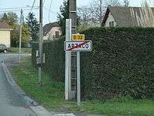
Arzacq-Arraziguet
| Arzacq-Arraziguet | ||
|---|---|---|
|
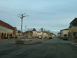
Main Street | ||
| ||
 Arzacq-Arraziguet | ||
|
Location within Nouvelle-Aquitaine region  Arzacq-Arraziguet | ||
| Coordinates: 43°32′12″N 0°24′41″W / 43.5367°N 0.4114°WCoordinates: 43°32′12″N 0°24′41″W / 43.5367°N 0.4114°W | ||
| Country | France | |
| Region | Nouvelle-Aquitaine | |
| Department | Pyrénées-Atlantiques | |
| Arrondissement | Pau | |
| Canton | Arzacq-Arraziguet | |
| Intercommunality | Canton d'Arzacq | |
| Government | ||
| • Mayor (2008–2020) | Henri Fam | |
| Area1 | 15.26 km2 (5.89 sq mi) | |
| Population (2010)2 | 1,010 | |
| • Density | 66/km2 (170/sq mi) | |
| Time zone | CET (UTC+1) | |
| • Summer (DST) | CEST (UTC+2) | |
| INSEE/Postal code | 64063 / 64410 | |
| Elevation |
95–238 m (312–781 ft) (avg. 224 m or 735 ft) | |
|
1 French Land Register data, which excludes lakes, ponds, glaciers > 1 km² (0.386 sq mi or 247 acres) and river estuaries. 2 Population without double counting: residents of multiple communes (e.g., students and military personnel) only counted once. | ||
Arzacq-Arraziguet is a French commune in the Pyrénées-Atlantiques department in the Nouvelle-Aquitaine region of south-western France.
The inhabitants of the commune are known as Arzacquois or Arzacquoises.[1]
Geography

Arzacq-Arraziguet is located in the north-east of the department and of Béarn, 30 km north of Pau and 40 km south of Mont-de-Marsan. The northern and north-eastern border of the commune is the border between the departments of Pyrénées-Atlantiques and Landes. Access to the commune is by the D944 road from Méracq in the south passing through the town and continuing north to Samadet. The D946 road comes from Morlanne in the west passing through the length of the commune and the town and continuing east to join the D834 just south of Garlin. The D246 branches off the D946 in the centre of the commune and goes north-west to join the D45 north of Piets-Plasence-Moustrou. The commune is mostly farmland but with many forests mainly towards the west.[2]
The Louts river passes through the commune from south-east to north-west where it continues north-west to eventually join the Adour on the border of the commune of Préchacq-les-Bains. The Arriou river rises in the south of the commune and flows north-west parallel to the Louts joining it north of the commune. The Luy de France forms the south-western border of the commune as it flows north-west to eventually join the Luy north of Castel-Sarrazin.[2]
Places and Hamlets[3]
- L'Abattoir
- Barot
- Borde
- La Borde
- Brioulou
- Castéra
- Castetber[4]
- Chatou
- Collongues
- Couillet
- Coutet
- Cruhot[5]
- Cussou
- Gaillat
- Gariman
- Gibardéou[6]
- Glesia[7]
- Gouaillard
- Higuères
- Hournas
- Jouanlanne
- Labère[8]
- Labus
- Lacoste
- Lafitte (two places)
- Lafounta
- Lafume
- Lahon
- Lanot
- Larribaou
- Lasterrières
- Laulhé
- Lhamounet
- Licorne
- Loué
- Loustalet
- Massou
- Millet
- Nabailh
- Naude
- Ninot
- Piarrot
- Pifre
- Pigat
- Pountet
- Pouy
- Rouquet
- Roux
- Salles[9]
- Sicut
- Sobole
- Ten
- Tristan[10]
- Vialé[7][11]
Neighbouring communes and villages[2]
 |
Philondenx | Lacajunte | Pimbo | |
| Cabidos | |
Coublucq | ||
| ||||
| | ||||
| Louvigny | Vignes | Pouliacq |
Toponymy
The name Arraziguet appears in the form:
- Raviguet (1793 or Year II[12]) and was not shown on the Cassini Map of 1750.[13]
Michel Grosclaude[13] indicated that the origin of the name is arrasic ("root" in Gascon), with the collective suffix -etum added giving "cluster of roots or stumps".
The name Arzacq appears in the forms:
Lo marcat d'Arsac (1542,[15] Reformation of Béarn B. 736[16]), at which time it came to Soule and Lower Navarre,
- Arzac (1620,[13] related to a journey by Louis XIII to Pau), and
- Arzac on the Cassini Map in 1750[13][17]
Its name in béarnais is Arsac. The name is of Gallo-Roman origin - the name of a former owner ("Domain of Arsius").[13][18]
Cherre was a hamlet in Arzacq, mentioned by the dictionary of 1863.[19]
The name Vialé appears in the form Le Vialé in the 1863 dictionary.[11]
History
On 14 and 15 October 1620, Louis XIII stopped in Arzacq on his way to Pau. The two aldermen of the town were then Pierre Dubern and Dominique de Meylon.
In 1790 the Canton of Arzacq comprised the same communes as today except the village of Riumayou, but including the commune of Momas.
Arraziguet was merged with Arzacq on 7 September 1845.[20]
Heraldry
.svg.png) |
Blazon: Gules, a greyhound courant of Or surmounted by a crescent the same, in chief Azure charged with 3 escallops of Or. |
Administration

List of Successive Mayors[21]
| From | To | Name | Party | Position |
|---|---|---|---|---|
| 1995 | 2020 | Henri Fam |
(Not all data is known)
Inter-communality
The commune is part of three inter-communal structures:[22]
- the Community of communes of Amrzacq;
- the AEP association of Arzacq;
- the Energy association of Pyrénées-Atlantiques;
Twinning
Arzacq-Arraziguet has twinning associations with:[23]
 Schwarzach (Germany) since 1995.
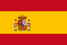 Luna (Spain) since 2004.
Demography
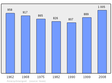
In 2010 the commune had 1,010 inhabitants. The evolution of the number of inhabitants is known from the population censuses conducted in the commune since 1793. From the 21st century, a census of communes with fewer than 10,000 inhabitants is held every five years, unlike larger towns that have a sample survey every year.[Note 1]
| 1793 | 1800 | 1806 | 1821 | 1831 | 1836 | 1841 | 1846 | 1851 |
|---|---|---|---|---|---|---|---|---|
| 810 | 741 | 1,100 | 1,004 | 976 | 957 | 1,288 | 1,326 | 1,346 |
| 1856 | 1861 | 1866 | 1872 | 1876 | 1881 | 1886 | 1891 | 1896 |
|---|---|---|---|---|---|---|---|---|
| 1,319 | 1,296 | 1,250 | 1,224 | 1,264 | 1,229 | 1,174 | 1,143 | 1,077 |
| 1901 | 1906 | 1911 | 1921 | 1926 | 1931 | 1936 | 1946 | 1954 |
|---|---|---|---|---|---|---|---|---|
| 1,091 | 1,118 | 1,104 | 986 | 954 | 959 | 963 | 906 | 916 |
| 1962 | 1968 | 1975 | 1982 | 1990 | 1999 | 2006 | 2010 | - |
|---|---|---|---|---|---|---|---|---|
| 958 | 917 | 865 | 826 | 807 | 889 | 978 | 1,010 | - |
Sources : Ldh/EHESS/Cassini until 1962, INSEE database from 1968 (population without double counting and municipal population from 2006)
Culture and Heritage
Civil heritage
The Gallo-Roman period in the commune was the subject of a study by the Ministry of Culture.[7]
There are many buildings in Arzacq-Arraziguet of many types which are registered as historical monuments. These are:
- Lavoir or Public laundry at Labère (19th century)
 [8] One of the first requirements at any Bastide was an ample supply of water. The Lavoir or Public laundry at Labère is oddly located several miles from the town in the open countryside. [24]
 - Presbytery House at Place du Marcadieu (19th century)[25]
- Mimbielle House at Place du Marcadieu (18th century)[26]
- Post Office at Place du Marcadieu (19th century)[27]
- House at Place du Marcadieu (18th century)[28]
- Butchery at Place de la République (15th, 16th, & 20th centuries)[29]
- House at Place de la République (15th, 16th, & 19th centuries)[30]
- Cafe at Place de la République (15th, 16th, 18th, & 19th centuries)[31]
- War Memorial (First World War)[32]
- House at Place de la République (18th & 19th centuries)[33]
- House at Place de la République (19th century)[34]
- Houses and Farms[35]
- Motte la Tourette Fortified complex (10th-14th centuries).[36] It includes a church, an outer courtyard, a mound, a moat, and an outer wall.
- Farms dating to the 19th century:
The Town Hall has a painting by Paul Mirat depicting the arrival of Louis XIII at Arzacq on 14 October 1620 which is registered as an historical object.![]() [37]
[37]
There is a Museum of Ham in Arzacq which traces the history of Bayonne ham.
Religious heritage
The Church of Saint-Pierre (19th century)![]() [38] is registered as a historical monument.
[38] is registered as a historical monument.
The church contains many items which are registered as historical objects. These are:
- Cross: Christ on the Cross (16th century)
 [39][40]
 - Statue: Virgin and child (16th century)[41]
- 23 Stained glass windows (19th century)[42]
- Choir enclosure (19th century)[43]
- Altar, Altar seating, Tabernacle (19th century)[44]
- Group Sculpture: Virgin and child surrounded by angels (15th century)[45]
- Baptismal fonts (18th century)[46]
- Stoup (16th century)[47]
- Furniture in the Church[48]
- Furniture in the Church (Supplementary list)[49]
Arzacq-Arraziguet is a stage on the via Podiensis (or Way of Puy), one of the modern paths on the Way of St. James from Puy-en-Velay and continues to the Roncesvalles Pass and from there to Santiago de Compostela. This is why the blazon of the town has three escallops.
Environmental heritage
The town has a lake and two marked trails, one of which is labelled sentiers d'Émilie.[50]
Facilities
- Education
The commune has an elementary school[51] and a college.[52] Arzacq also has a training establishment and a maternal assistance clinic.
Notable people linked to the commune
- Damien Catalogne, born at Arzacq in 1856 and died at Arzacq in 1934, was a French politician.
- Georges Visat, born on 2 January 1910, at Foce Di Mela (Corsica) and died on 2 February 2001 at Arzacq-Arraziguet, was an engraver, art editor, and French painter.
See also
External links
- Official commune website (French)
- La bastide (French)
- Arzacq-Arraziguet on Géoportail, National Geographic Institute (IGN) website (French)
- Arzac on the 1750 Cassini Map
- Arzacq-Arraziguet on the INSEE website (French)
- INSEE (French)
Notes and references
Notes
- ↑ At the beginning of the 21st century, the methods of identification have been modified by Law No. 2002-276 of 27 February 2002, the so-called "law of local democracy" and in particular Title V "census operations" allows, after a transitional period running from 2004 to 2008, the annual publication of the legal population of the different French administrative districts. For communes with a population greater than 10,000 inhabitants, a sample survey is conducted annually, the entire territory of these communes is taken into account at the end of the period of five years. The first "legal population" after 1999 under this new law came into force on 1 January 2009 and was based on the census of 2006.
References
- ↑ Inhabitants of Pyrénées-Atlantiques (French)
- 1 2 3 Google Maps
- ↑ Géoportail, IGN (French)
- 1 2 Ministry of Culture, Mérimée IA64000207 Farm at Castetber (French)
- 1 2 Ministry of Culture, Mérimée IA64000205 Farm at Cruhot (French)
- 1 2 Ministry of Culture, Mérimée IA64000206 Farm at Gibardéou (French)
- 1 2 3 Ministry of Culture, Mérimée IA64000004 Presentation of the Gallo-Roman period (French)
- 1 2 Ministry of Culture, Mérimée IA64000003 Lavoir at Labère
- 1 2 Ministry of Culture, Mérimée IA64000203 Farm at Salles (French)
- 1 2 Ministry of Culture, Mérimée IA64000202 Farm at Tristan (French)
- 1 2 Topographic Dictionary of the Department of Basses-Pyrenees, p. 173 (French)
- ↑ Page on Arraziguet on the Cassini project website of EHESS (French)
- 1 2 3 4 5 6 Michel Grosclaude, Toponymic Dictionary of communes, Béarn, Edicions reclams & Édition Cairn - 2006, 416 pages, ISBN 2 35068 005 3 (French)
- ↑ Manuscript from the 14th century - Departmental Archives of Pyrénées-Atlantiques (French)
- ↑ Topographic Dictionary of the Department of Basses-Pyrenees, Paul Raymond, Imprimerie nationale, 1863, Digitised from Lyon Public Library 15 June 2011, p. 14 (French)
- ↑ Manuscript from the 16th to 18th centuries - Departmental Archives of Pyrénées-Atlantiques (French)
- ↑ Cassini Map 1750 - Arzac
- ↑ History page on the Town Hall website (French)
- ↑ Topographic Dictionary of the Department of Basses-Pyrenees, p. 49 (French)
- ↑ Ministry of Culture, Mérimée IA64000148 Presentation of the commune
- ↑ List of Mayors of France (French)
- ↑ Intercommunality of Pyrénées-Atlantiques, Cellule informatique préfecture 64, consulted on 2 April 2012 (French)
- ↑ National Commission for Decentralised cooperation (French)
- ↑ "Location: Arzacq-Arrasiguet - John Reps Bastides Collection Search Results". bastides.library.cornell.edu. Retrieved 2016-05-09.
- ↑ Ministry of Culture, Mérimée IA64000196 Presbytery House (French)
- ↑ Ministry of Culture, Mérimée IA64000195 Mimbielle House (French)
- ↑ Ministry of Culture, Mérimée IA64000200 Post Office (French)
- ↑ Ministry of Culture, Mérimée IA64000199 House at the place Marcadieu (French)
- ↑ Ministry of Culture, Mérimée IA64000194 Old butchery in the Place de la République (French)
- ↑ Ministry of Culture, Mérimée IA64000008 House in the Place de la République (French)
- ↑ Ministry of Culture, Mérimée IA64000007 Manor House / Cafe in the Place de la République (French)
- ↑ Ministry of Culture, Mérimée IA64000005 War Memorial (French)
- ↑ Ministry of Culture, Mérimée IA64000198 House at the Place de la République (French)
- ↑ Ministry of Culture, Mérimée IA64000197 House at the Place de la République (French)
- ↑ Ministry of Culture, Mérimée IA64000170 Houses and Farms (French)
- ↑ Ministry of Culture, Mérimée IA64000006 Motte la Tourette (French)
- ↑ Ministry of Culture, Palissy IM64002820 Painting in the Town Hall (French)
- ↑ Ministry of Culture, Mérimée IA64000002 Church of St. Peter (French)
- ↑ Ministry of Culture, Palissy PM64000043 Christ on the Cross (French)
- ↑ Ministry of Culture, Palissy IM64002652 Christ on the Cross (French)
- ↑ Ministry of Culture, Palissy PM64000042 Statue: Virgin and child (French)
- ↑ Ministry of Culture, Palissy IM64002737 23 Stained glass windows (French)
- ↑ Ministry of Culture, Palissy IM64002736 Choir enclosure (French)
- ↑ Ministry of Culture, Palissy IM64002735 Altar, Altar seating, Tabernacle (French)
- ↑ Ministry of Culture, Palissy IM64002656 Group Sculpture: Virgin and child surrounded by angels (French)
- ↑ Ministry of Culture, Palissy IM64002655 Baptismal fonts (French)
- ↑ Ministry of Culture, Palissy IM64002654 Stoup (French)
- ↑ Ministry of Culture, Palissy IM64002653 Furniture in the Church (French)
- ↑ Ministry of Culture, Palissy IM64002781 Furniture in the Church (Supplementary list) (French)
- ↑ Tourism page on the commune website (French)
- ↑ Elementary School on the commune website (French)
- ↑ College of Arzacq on the commune website (French)
| Wikimedia Commons has media related to Arzacq-Arraziguet. |