Hosta, Pyrénées-Atlantiques
| Hosta | |
|---|---|
 | |
 Hosta | |
|
Location within Nouvelle-Aquitaine region  Hosta | |
| Coordinates: 43°09′33″N 1°05′12″W / 43.1592°N 1.0867°WCoordinates: 43°09′33″N 1°05′12″W / 43.1592°N 1.0867°W | |
| Country | France |
| Region | Nouvelle-Aquitaine |
| Department | Pyrénées-Atlantiques |
| Arrondissement | Bayonne |
| Canton | Iholdy |
| Intercommunality | Iholdi-Ostibarre |
| Government | |
| • Mayor (2001–2008) | Yves Lascor |
| Area1 | 17.08 km2 (6.59 sq mi) |
| Population (2006)2 | 81 |
| • Density | 4.7/km2 (12/sq mi) |
| Time zone | CET (UTC+1) |
| • Summer (DST) | CEST (UTC+2) |
| INSEE/Postal code | 64265 / 64120 |
| Elevation |
260–1,155 m (853–3,789 ft) (avg. 442 m or 1,450 ft) |
|
1 French Land Register data, which excludes lakes, ponds, glaciers > 1 km² (0.386 sq mi or 247 acres) and river estuaries. 2 Population without double counting: residents of multiple communes (e.g., students and military personnel) only counted once. | |
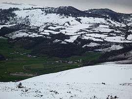
Hosta (Basque: Hozta) is a commune in the Pyrénées-Atlantiques department in south-western France.
It is located in the former province of Lower Navarre.
See also
References
External links
| Wikimedia Commons has media related to Hosta (Pyrénées-Atlantiques). |
This article is issued from Wikipedia - version of the 7/17/2015. The text is available under the Creative Commons Attribution/Share Alike but additional terms may apply for the media files.