Salies-de-Béarn
| Salies-de-Béarn | ||
|---|---|---|
|
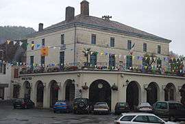
Town Hall | ||
| ||
 Salies-de-Béarn | ||
|
Location within Nouvelle-Aquitaine region  Salies-de-Béarn | ||
| Coordinates: 43°28′16″N 0°55′30″W / 43.471°N 0.925°WCoordinates: 43°28′16″N 0°55′30″W / 43.471°N 0.925°W | ||
| Country | France | |
| Region | Nouvelle-Aquitaine | |
| Department | Pyrénées-Atlantiques | |
| Arrondissement | Pau | |
| Canton | Salies-de-Béarn | |
| Intercommunality | Salies-de-Béarn | |
| Government | ||
| • Mayor (2001–2008) | Lucien Basse-Cathalinat | |
| Area1 | 52.08 km2 (20.11 sq mi) | |
| Population (2006)2 | 4,993 | |
| • Density | 96/km2 (250/sq mi) | |
| Time zone | CET (UTC+1) | |
| • Summer (DST) | CEST (UTC+2) | |
| INSEE/Postal code | 64499 / 64270 | |
| Elevation |
28–202 m (92–663 ft) (avg. 56 m or 184 ft) | |
|
1 French Land Register data, which excludes lakes, ponds, glaciers > 1 km² (0.386 sq mi or 247 acres) and river estuaries. 2 Population without double counting: residents of multiple communes (e.g., students and military personnel) only counted once. | ||
.svg.png)
Salies-de-Béarn (Occitan: Salias) is a commune in the Pyrénées-Atlantiques department in south-western France.
The name comes from its naturally occurring saline water (Gascon salias for Standard Occitan salinas). During the occupation of France by Nazi Germany, Salies was on the border between the occupied zone and the free zone.
Salies-de-Bearn served as the setting for the writer Trevanian's novel, The Summer of Katya. In the book, it was renamed Salies-les-Bains.
See also
References
| Wikimedia Commons has media related to Salies-de-Béarn. |
This article is issued from Wikipedia - version of the 7/29/2016. The text is available under the Creative Commons Attribution/Share Alike but additional terms may apply for the media files.