Ascarat
| Ascarat | ||
|---|---|---|
|
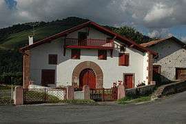
Traditional Farmhouse in Ascarat | ||
| ||
 Ascarat | ||
|
Location within Nouvelle-Aquitaine region  Ascarat | ||
| Coordinates: 43°10′17″N 1°15′14″W / 43.1714°N 1.2539°WCoordinates: 43°10′17″N 1°15′14″W / 43.1714°N 1.2539°W | ||
| Country | France | |
| Region | Nouvelle-Aquitaine | |
| Department | Pyrénées-Atlantiques | |
| Arrondissement | Bayonne | |
| Canton | Saint-Étienne-de-Baïgorry | |
| Intercommunality | Garazi-Baïgorri | |
| Government | ||
| • Mayor (1995–2020) | Jean-Michel Galant | |
| Area1 | 5.82 km2 (2.25 sq mi) | |
| Population (2010)2 | 312 | |
| • Density | 54/km2 (140/sq mi) | |
| Time zone | CET (UTC+1) | |
| • Summer (DST) | CEST (UTC+2) | |
| INSEE/Postal code | 64066 / 64220 | |
| Elevation |
120–446 m (394–1,463 ft) (avg. 161 m or 528 ft) | |
|
1 French Land Register data, which excludes lakes, ponds, glaciers > 1 km² (0.386 sq mi or 247 acres) and river estuaries. 2 Population without double counting: residents of multiple communes (e.g., students and military personnel) only counted once. | ||
Ascarat (Basque: Azkarate) is a French commune in the Pyrénées-Atlantiques department in the Nouvelle-Aquitaine region of south-western France.
The inhabitants are known as Azkaratear.[1][2]
Geography
Ascarat is located in the former province of Lower Navarre in the Aldudes Valley immediately north-west of Saint-Jean-Pied-de-Port. Access to the commune is by the D918 road from Saint-Jean-Pied-de-Port which passes through the length of the commune on the eastern side and continues to Louhossoa. The D15 road goes north-west from Saint-Jean-Pied-de-Port through the southern part of the commune continuing to Irouléguy. Access to the village is by country roads - Garategana from the D15 and Learraa from the D918. There are substantial forests in the commune however about 70% of the land area is farmland.[3]
The Nive river forms the eastern border of the commune as it flows north to join the Adour at Bayonne. Three streams flow into the Nive in the commune: the Nive d'Arnéguy, the Nive de Béhérobie, the Berroko erreka, and the Pagolako erreka.[3]
Places and hamlets[4]
- Apelchénéa
- Arbelarréa
- Arrécharborda
- Béhérekoetchéa
- Bentaberria
- Beskinaénéa
- Bidartéa
- Bordia
- Burugorriénéa
- Caracotchéa
- Choko Ona
- Errékaldéa
- Fargas (château)
- Ferrandoénéa
- Garatégaïna
- Haranbiako Borda
- Harguinaénéa
- Harguinchuria
- Hirureta
- Indartéa
- Iputchaénéa
- Ithurraldéa
- Ithurricheta
- Jauberria
- Pontoussénéa
- Puchulua
- La Solitude
- Tofinaenea
- Uhaldéa
Neighbouring communes and villages[3]
 |
Irouléguy | Ossès | Suhescun | |
| Anhaux | |
Bustince-Iriberry | ||
| ||||
| | ||||
| Lasse | Saint-Jean-Pied-de-Port |
Toponymy
The name Ascarat appears in the forms:
- Ascarat (1106[5]),
- Escarat (13th century[5]),
- Azcarat (1350[5]),
- Atzcarat (1366[5]),
- Azquarat (1413[5]),
- Axcarat (1513,[6] Titles of Pamplona[7]),
- Axcarate (1621,[6] Martin Biscay[8]), and
- Sanctus Julianus d'Ascarat (1763,[6] Collations of the Diocese of Bayonne[9]).
Jean-Baptiste Orpustan indicated that the name is composed of aitz ("rock") and garate ("high place"), giving "a height of rocks".[5]
Chubitoa was a hamlet in Ascarat and Anhaux, mentioned in 1863[10]
Jauréguy was a fief, vassal of the Kingdom of Navarre, cited in the 1863 dictionary[11] as was Larragoyen.[12]
The commune name in basque is Azkarate.[2]
History
The parish was mentioned in 1256 and was "ravaged by soldiers" in 1396.[13]
In 1391 Saint-Étienne-de-Baïgorry included the modern communes of Anhaux, Ascarat, Irouléguy, and Lasse.[14]
Heraldry
.svg.png) |
Blazon: Quarterly, at 1 Azure, a vine stalk leaved in Argent, fruited in Or; at 2 Argent an eagle rising of Sable on a mount of Vert; at 3 Argent with 2 fesses of Gules; at 4 Azure with a horse gai passant of Or surmounted by two mullets of Argent posed in fesse, a canton sinister of Gules charged with a sword of Argent. |
Administration
List of Successive Mayors[15]
| From | To | Name | Party | Position |
|---|---|---|---|---|
| 1995 | 2020 | Jean-Michel Galant | AB | General Councillor |
(Not all data is known)
Inter-communality
The commune is part of nine inter-communal structures:[16]
- the Community of communes of Garazi-Baigorri;
- the SIVOS of Garazi;
- the SIVU Hiruen Artean;
- the AEP association of Anhice;
- the Energy association of Pyrénées-Atlantiques;
- the inter-communal association for sanitation of Ur Garbi;
- the inter-communal association for the management and development of the abattoir at Saint-Jean-Pied-de-Port;
- the joint association for the Drainage basin of the Nive;
- the association to support Basque culture.
Demography
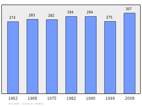
In 2010 the commune had 312 inhabitants. The evolution of the number of inhabitants is known from the population censuses conducted in the commune since 1793. From the 21st century, a census of communes with fewer than 10,000 inhabitants is held every five years, unlike larger towns that have a sample survey every year.[Note 1]
| 1793 | 1800 | 1806 | 1821 | 1831 | 1836 | 1841 | 1846 | 1851 |
|---|---|---|---|---|---|---|---|---|
| 334 | 260 | 279 | 369 | 402 | 441 | 440 | 445 | 403 |
| 1856 | 1861 | 1866 | 1872 | 1876 | 1881 | 1886 | 1891 | 1896 |
|---|---|---|---|---|---|---|---|---|
| 340 | 375 | 354 | 360 | 353 | 350 | 354 | 346 | 412 |
| 1901 | 1906 | 1911 | 1921 | 1926 | 1931 | 1936 | 1946 | 1954 |
|---|---|---|---|---|---|---|---|---|
| 338 | 350 | 354 | 321 | 323 | 355 | 353 | 348 | 325 |
| 1962 | 1968 | 1975 | 1982 | 1990 | 1999 | 2006 | 2010 | - |
|---|---|---|---|---|---|---|---|---|
| 274 | 283 | 282 | 294 | 294 | 275 | 280 | 312 | - |
Sources : Ldh/EHESS/Cassini until 1962, INSEE database from 1968 (population without double counting and municipal population from 2006)
Economy
The commune is part of the production zone of the Appellation d'origine contrôlée (AOC) of Irouléguy and also of the AOC zone of Ossau-iraty.
Economic activity is mainly agricultural.
Culture and heritage
Civil heritage
There are several houses and farms in the commune which are registered as historical monuments. These are:
- Uhaldea House (18th century)
 [17]
[17] - Harizpea Farm (1587)[18]
- Chateau de Vergues (or Chateau de Fargas) (18th century)[19]
- Houses and Farms (17th-19th centuries)[20]
Religious heritage
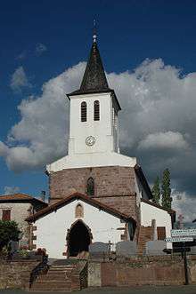
The Church of Saint-Julien-d'Antioche![]() is of medieval origin was heavily rebuilt in the 18th and 19th century.[21]
is of medieval origin was heavily rebuilt in the 18th and 19th century.[21]
Notable people linked to the commune
- Pierre Narbaitz, born in 1910 at Ascarat and died in 1984 at Cambo-les-Bains, was a historian, writer, and a basque French academic of the Basque and French languages.
See also
External links
- AZKARATE in the Bernardo Estornés Lasa - Auñamendi Encyclopedia (Euskomedia Fundazioa) (Spanish)
- Ascarat on Google Maps
- Ascarat on Géoportail, National Geographic Institute (IGN) website (French)
- Azcarat on the 1750 Cassini Map
- Ascarat on the INSEE website (French)
- INSEE (French)
Notes and references
Notes
- ↑ At the beginning of the 21st century, the methods of identification have been modified by Law No. 2002-276 of 27 February 2002, the so-called "law of local democracy" and in particular Title V "census operations" allows, after a transitional period running from 2004 to 2008, the annual publication of the legal population of the different French administrative districts. For communes with a population greater than 10,000 inhabitants, a sample survey is conducted annually, the entire territory of these communes is taken into account at the end of the period of five years. The first "legal population" after 1999 under this new law came into force on 1 January 2009 and was based on the census of 2006.
References
- ↑ Brigitte Jobbé-Duval, Dictionary of place names - Pyrénées-Atlantiques, 2009, Archives and Culture, ISBN 978-2-35077-151-9 (French)
- 1 2 Euskaltzaindia - Academy of the Basque language (Basque)
- 1 2 3 Google Maps
- ↑ Géoportail, IGN (French)
- 1 2 3 4 5 6 Jean-Baptiste Orpustan, New Basque Toponymy, Presses universitaires de Bordeaux, 2006, ISBN 2 86781 396 4 (French)
- 1 2 3 Topographic Dictionary of the Department of Basses-Pyrenees, Paul Raymond, Imprimerie nationale, 1863, Digitised from Lyon Public Library 15 June 2011, p. 15 (French)
- ↑ Titles published by don José Yanguas y Miranda (French)
- ↑ Derecho de naturaleza que la merindad de San-Juan-del-pie-del-puerto, una de las seys de Navarra, tiene en Castilla - 1622 petit in-4° (Spanish)
- ↑ Manuscripts from the 17th and 18th centuries - Departmental Archives of Pyrénées-Atlantiques (French)
- ↑ Topographic Dictionary of the Department of Basses-Pyrenees, p. 50 (French)
- ↑ Topographic Dictionary of the Department of Basses-Pyrenees, p. 85 (French)
- ↑ Topographic Dictionary of the Department of Basses-Pyrenees, p. 94 (French)
- ↑ Ministry of Culture, Mérimée IA64000420 Presentation of the commune of Ascarat (French)
- ↑ Ministry of Culture, Mérimée IA64000425 Presentation of the commune of Saint-Étienne-de-Baïgorry (French)
- ↑ List of Mayors of France (French)
- ↑ Intercommunality of Pyrénées-Atlantiques, Cellule informatique préfecture 64, consulted on 2 March 2012 (French)
- ↑ Ministry of Culture, Mérimée IA64000459 Uhaldea House (French)
- ↑ Ministry of Culture, Mérimée IA64000416 Harizpea Farm (French)
- ↑ Ministry of Culture, Mérimée IA64000415 Chateau de Vergues (French)
- ↑ Ministry of Culture, Mérimée IA64000486 Houses and Farms (French)
- ↑ Ministry of Culture, Mérimée IA64000414 Church of Saint-Julien-d'Antioche (French)
| Wikimedia Commons has media related to Ascarat. |