Asherville, Indiana
| Asherville | |
|---|---|
| Unincorporated community | |
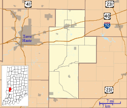 Asherville Location in Clay County | |
| Coordinates: 39°28′29″N 87°03′44″W / 39.47472°N 87.06222°WCoordinates: 39°28′29″N 87°03′44″W / 39.47472°N 87.06222°W | |
| Country | United States |
| State | Indiana |
| County | Clay |
| Township | Jackson |
| Elevation | 659 ft (201 m) |
| ZIP code | 47834 |
| FIPS code | 18-02368[1] |
| GNIS feature ID | 447632[2] |
Asherville is an unincorporated community in Jackson Township, Clay County, Indiana. It is part of the Terre Haute Metropolitan Statistical Area.
History
Asherville was laid out in 1873 by John Asher.[3] A post office was established at Asherville in 1873, and remained in operation until it was discontinued in 1912.[4]
Geography
Asherville is located at 39°28′29″N 87°03′44″W / 39.47472°N 87.06222°W.
References
- ↑ "American FactFinder". United States Census Bureau. Archived from the original on 2013-09-11. Retrieved 2008-01-31.
- ↑ "Asherville, Indiana". Geographic Names Information System. United States Geological Survey. Retrieved 2009-10-10.
- ↑ Blanchard, Charles (1884). Counties of Clay and Owen, Indiana: Historical and Biographical. F.A. Battey & Company. p. 298.
- ↑ "Clay County". Jim Forte Postal History. Retrieved 30 August 2014.
Municipalities and communities of Clay County, Indiana, United States | ||
|---|---|---|
| City | ||
| Towns | ||
| Townships | ||
| CDP | ||
| Other unincorporated communities |
| |
| Ghost towns | ||
| Footnotes | ‡This populated place also has portions in an adjacent county or counties | |
This article is issued from Wikipedia - version of the 10/19/2016. The text is available under the Creative Commons Attribution/Share Alike but additional terms may apply for the media files.