Turner, Indiana
| Turner | |
|---|---|
| Unincorporated community | |
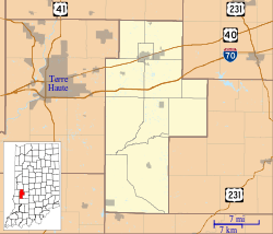 Turner Location in Clay County | |
| Coordinates: 39°29′54″N 87°09′37″W / 39.49833°N 87.16028°WCoordinates: 39°29′54″N 87°09′37″W / 39.49833°N 87.16028°W | |
| Country | United States |
| State | Indiana |
| County | Clay |
| Township | Posey |
| Elevation[1] | 673 ft (205 m) |
| ZIP code | 47834 |
| FIPS code | 18-76832[2] |
| GNIS feature ID | 444989 |
Turner is an unincorporated community in Posey Township, Clay County, Indiana. It is part of the Terre Haute Metropolitan Statistical Area.
Geography
Turner is located at 39°29′54″N 87°09′37″W / 39.49833°N 87.16028°W.
History
Turner was originally known as Newburg and was founded as such in 1854 by Joshua Modesitt along the Terre Haute and Indianapolis railroad. The post office was renamed Turner during the 1870s. When once thriving, the town had several general stores, a pottery, a United Brethran congregation, and several schools. The railroad is no longer in existence, although one can still observe evidence of such in the form of cleared paths through thickets in and around the town.[3]
References
- ↑ "US Board on Geographic Names". United States Geological Survey. 2007-10-25. Retrieved 2008-01-31.
- ↑ "American FactFinder". United States Census Bureau. Retrieved 2008-01-31.
- ↑ Clay County Interim Report, published by Historic Landmarks Foundation of Indiana
Municipalities and communities of Clay County, Indiana, United States | ||
|---|---|---|
| City | ||
| Towns | ||
| Townships | ||
| CDP | ||
| Other unincorporated communities |
| |
| Ghost towns | ||
| Footnotes | ‡This populated place also has portions in an adjacent county or counties | |
This article is issued from Wikipedia - version of the 9/3/2016. The text is available under the Creative Commons Attribution/Share Alike but additional terms may apply for the media files.