Hoosierville, Indiana
| Hoosierville | |
|---|---|
| Unincorporated community | |
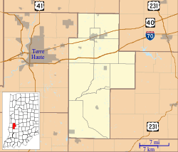 Hoosierville Location in Clay County | |
| Coordinates: 39°28′30″N 87°06′30″W / 39.47500°N 87.10833°WCoordinates: 39°28′30″N 87°06′30″W / 39.47500°N 87.10833°W | |
| Country | United States |
| State | Indiana |
| County | Clay |
| Township | Jackson |
| Elevation | 653 ft (199 m) |
| ZIP code | 47834 |
| FIPS code | 18-34690[1] |
| GNIS feature ID | 436417[2] |
Hoosierville is an unincorporated community in Jackson Township, Clay County, Indiana. It is part of the Terre Haute Metropolitan Statistical Area.
History
A post office was established at Hoosierville in 1874, and remained in operation until it was discontinued in 1902.[3] It was named from Indiana's official demonym, Hoosier.[4]
Mining was originally the primary industry of Hoosierville.[5]
Geography
Hoosierville is located at 39°28′30″N 87°06′30″W / 39.47500°N 87.10833°W.
References
- ↑ "American FactFinder". United States Census Bureau. Retrieved 2008-01-31.
- ↑ "Hoosierville, Indiana". Geographic Names Information System. United States Geological Survey. Retrieved 2009-10-17.
- ↑ "Clay County". Jim Forte Postal History. Retrieved 30 August 2014.
- ↑ Baker, Ronald L. (October 1995). From Needmore to Prosperity: Hoosier Place Names in Folklore and History. Indiana University Press. p. 171. ISBN 978-0-253-32866-3.
...named for its location in the Hoosier state.
- ↑ Blanchard, Charles (1884). Counties of Clay and Owen, Indiana: Historical and Biographical. F.A. Battey & Company. p. 298.
Municipalities and communities of Clay County, Indiana, United States | ||
|---|---|---|
| City | ||
| Towns | ||
| Townships | ||
| CDP | ||
| Other unincorporated communities |
| |
| Ghost towns | ||
| Footnotes | ‡This populated place also has portions in an adjacent county or counties | |
This article is issued from Wikipedia - version of the 10/3/2016. The text is available under the Creative Commons Attribution/Share Alike but additional terms may apply for the media files.