Ashland, Natchitoches Parish, Louisiana
| Ashland, Louisiana | |
| Village | |
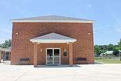
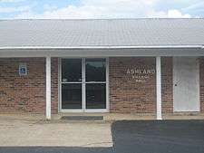 Ashland Village Hall is located next to the United States Post Office building | |
| Country | United States |
|---|---|
| State | Louisiana |
| Parish | Natchitoches |
| Elevation | 226 ft (68.9 m) |
| Coordinates | 32°06′59″N 93°06′53″W / 32.11639°N 93.11472°WCoordinates: 32°06′59″N 93°06′53″W / 32.11639°N 93.11472°W |
| Area | 27.1 sq mi (70.2 km2) |
| - land | 27.1 sq mi (70 km2) |
| - water | 0.0 sq mi (0 km2), 0% |
| Population | 269 (2010) |
| Density | 9.69/sq mi (3.7/km2) |
| Incorporated | 1963 |
| Mayor | Mayor W. Gahagan Lee |
| Timezone | CST (UTC-6) |
| - summer (DST) | CDT (UTC-5) |
| Area code | 318 |
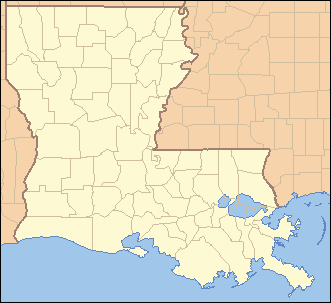 Location of Ashland in Louisiana
| |
 Location of Louisiana in the United States
| |

_Baptist_Church_IMG_0737.JPG)
Ashland is a village in the northernmost portion of Natchitoches Parish, Louisiana, United States. A few residences and a convenience store to the north spill over into neighboring Bienville Parish. The population was 291 at the 2000 census but declined 9 percent to 269 in 2010. The median age is 45.7 years.[1] Ashland is part of the Natchitoches Micropolitan Statistical Area but is located nearly forty miles to the north of the parish seat of Natchitoches.
The Ashland mayor is W. Gahagan Lee. The village council consists of Wayne Best and Carol Doyle, both Democrats, and Vincent Bown, a Republican. The police chief is Fred Holland, a Democrat.[2] All of the Ashland town officials were unopposed for new terms in the primary election held on October 2, 2010.
On September 2, 2011, a forest fire destroyed ten houses between Ashland and Creston, but residents escaped personal injury. According to Louisiana Commissioner of Agriculture and Forestry Mike Strain, the blaze scorched several thousand acres and was propelled by past drought conditions combined with high winds coming from the aftermath of Tropical Storm Lee in the Gulf of Mexico.[3]
History
The regional railroad, the Louisiana and Arkansas Railway (1898–1992), owned by William Buchanan, William Edenborn, and later Harvey C. Couch,[4] came through Ashland in 1899. A turntable was constructed on land that was subdivided by Andrew R. Johnson, an Alabama native. Johnson named the community in 1901 after his former city of residence, Ashland in northern Wisconsin.[5] There was a railroad passenger and freight station, equipped with a platform for lifting cotton into the cars. Railroad cross ties were also manufactured in Ashland.[6]
Cotton and corn were the principal crops in Ashland at the turn of the 20th century. The pioneers of Ashland are described in a history penned by H. Welborn Ayres as "fiercely independent", having refused an offer of government grain assistance during the 1896-1898 drought. Joe A. Pullig (1849–1926) operated a general store, later in partnership with William McCain. Pullig's business was near the newly opened United States Post Office, which was managed by the postmaster D. F. "Dave" Williams. Mail at the time reached Ashland by the bayou at Lake Village five miles (8 km) to the west. There was also a Carlile Hotel, long since demolished, which was owned by Tom and Duck Carlile and located east of the railroad track.[6]
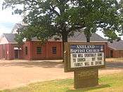
No businesses except the convenience store in Bienville Parish exist in Ashland today though there were a half dozen in the 1950s. The Ashland Baptist Church, Village Hall, Masonic lodge hall, and Post Office remain the principal entities. The lack of business in 1979 compelled Welborn Ayres to equate Ashland with "The Deserted Village" of the Oliver Goldsmith poem.[6]
In 2001, Ashland celebrated its centennial with a spring festival, still held during the last weekend of March.[5]
Former Ashland High School
Originally a one-room structure, Ashland High School operated from 1907 until its closing in 1981. Judge Welborn Ayres refers to it as "one of the foremost rural high schools in the state,"[6] having offered instruction even in the less-studied subjects of physics and medieval history. A. R. Johnson, who had once taught school in Arkansas, donated the land for the original public school. Later a banker and the mayor of Homer[6] in Claiborne Parish, Johnson also served in the Louisiana State Senate from 1916–1924, having represented Bienville and Claiborne parishes.[7]
A former Natchitoches Parish branch library, operated from the home of Eleanor Walker Bamburg (1915–2010), a librarian for forty years,[8] was located across from the high school and the former store of Alvah Hume Dupree (1901–1974). After it closed, a bookmobile began coming weekly to the village hall for the benefit of library patrons. Nearby also was a once popular horseback riding club arena.
People from Ashland
Physicians
- In the first four decades of the 20th century, Ashland had at least one physician. Two are mentioned in Ayres' history, Samuel Lawrence Joyner (1876–1934) and Wiley W. Gahagan.[6]
- Dr. Joyner's son, Ben Joyner (1909–1981), was a Baptist minister who was living in Mansfield in De Soto Parish at the time of his death.[9]
- Another Dr. Gahagan, Henry Cole Gahagan, Sr. (December 1, 1908−December 17, 1996), was an Ashland native who graduated from the Tulane University Medical School in New Orleans and completed his residency at Johns Hopkins Medical School in Baltimore, Maryland. He served as a lieutenant colonel in the United States Army Medical Corps during World War II. He practiced medicine in Alexandria, Louisiana. He was married to the former Ernestine Kinnebrew. He retired to Natchitoches, where he died at the age of eighty-eight. He is interred at the historic American Cemetery in Natchitoches.[10][11]
Other community residents
- Edward H. Ayres (1910–1971), formerly of Ashland, served during the 1950s and 1960s as the Jackson Parish clerk of court in Jonesboro.[6][12]
- Harrison Welborn Ayres (1900–1985),[9] a graduate of the former Ashland High School, practiced law from 1925-1942 in Arcadia and Jonesboro. In 1942, he was elected state district court judge for Bienville, Claiborne, and Jackson parishes, a position that he held until January 1, 1954, when he became a judge of the Second Circuit Court of Appeals based in Shreveport. Judge Ayres served on the appeals court until his mandatory retirement at the age of seventy-five on April 30, 1975.[6]
- Annie Bell Price Coffey (1906-2012), a native of Bienville Parish, was the long-term clerk at the First Baptist Church and the Ashland correspondent for The Natchitoches Times newspaper. She was married to Robert Henry Coffey (1903-1980).[13]
- Irby Love Knotts, Jr. (1914–1995),[9] originally from Ashland, served as a Natchitoches Parish clerk of court and from 1976-1977 headed the Louisiana Clerks of Court Association.[14]
- Madison R. Lay (1864–1930),[15] an Ashland native and the father of the educators Orie Lay and Dovie Lillias Lay Dupree, was among the first class of students enrolled in the Louisiana Normal School, located in Natchitoches, in its inaugural year of 1885. Later known as Louisiana State Normal College and Northwestern State College, the institution is now Northwestern State University.[16]
- Tillman Rupert Pullig (1922-2011), a 1939 Ashland High School graduate and a United States Navy veteran of World War II, held a Ph.D. from Louisiana State University in Baton Rouge. He was a retired organic chemist for Texaco, having worked in Ghent, Belgium; Whittier, California, Beacon, New York, and Port Arthur, Texas.[17] The son of railroad employee Tillman Arthur Pullig (1898–1976) and the former Eula Finley (1900–1984),[18] Pullig had resided since 1983 in Jasper, Texas, where he died in a hospital on June 1, 2011, at the age of eighty-eight.[17]
- Stuart David Toms (born 1941) played basketball from 1960 to 1963 at the University of Louisiana at Monroe under Coach Lenny Fant. He spent his early years in Ashland and is the retired pastor of the Sweetwater Baptist Church in Quitman in Jackson Parish. In 1995, Toms was inducted into the Louisiana High School Athletic Association.[19]
- Bayli Quick (born 1998), class of 2017 of Lakeview High School. Louisiana FFA Area II Treasurer (2014-2015) and Area II Secretary (2016-2017). Lakeview FFA Secretary (2014-2016). Daughter of Ronnie and Angel Quick. Granddaughter of Beatrice and Aubrey Quick.
Geography
Ashland is located at 32°6′59″N 93°6′53″W / 32.11639°N 93.11472°W (32.116429, -93.114751).[20]
According to the United States Census Bureau, the village has a total area of 27.1 square miles (70 km2). 27.1 square miles (70 km2) of it is land and 0.04 square miles (0.10 km2) of it (0.07%) is water.
Climate
Climate is characterized by relatively high temperatures and evenly distributed precipitation throughout the year. According to the Köppen Climate Classification system, Ashland has a humid subtropical climate, abbreviated "Cfa" on climate maps.[21]
| Climate data for Ashland, Louisiana | |||||||||||||
|---|---|---|---|---|---|---|---|---|---|---|---|---|---|
| Month | Jan | Feb | Mar | Apr | May | Jun | Jul | Aug | Sep | Oct | Nov | Dec | Year |
| Average high °C (°F) | 13 (56) |
16 (61) |
20 (68) |
24 (76) |
28 (83) |
32 (89) |
34 (93) |
34 (93) |
31 (87) |
26 (78) |
20 (68) |
15 (59) |
24.4 (75.9) |
| Average low °C (°F) | 1 (33) |
2 (36) |
6 (43) |
11 (52) |
16 (60) |
19 (67) |
21 (70) |
21 (69) |
17 (63) |
11 (51) |
6 (42) |
2 (35) |
11.1 (51.8) |
| Average precipitation mm (inches) | 124 (4.9) |
122 (4.8) |
122 (4.8) |
117 (4.6) |
127 (5.0) |
107 (4.2) |
107 (4.2) |
79 (3.1) |
91 (3.6) |
89 (3.5) |
112 (4.4) |
132 (5.2) |
1,326 (52.2) |
| Source: Weatherbase [22] | |||||||||||||
Demographics
| Historical population | |||
|---|---|---|---|
| Census | Pop. | %± | |
| 1970 | 211 | — | |
| 1980 | 289 | 37.0% | |
| 1990 | 289 | 0.0% | |
| 2000 | 291 | 0.7% | |
| 2010 | 269 | −7.6% | |
| Est. 2015 | 263 | [23] | −2.2% |
As of the census[25] of 2000, there were 291 people, 121 households, and 87 families residing in the village. The population density was 10.7 inhabitants per square mile (4.1/km²). There were 149 housing units at an average density of 5.5 per square mile (2.1/km²). The racial makeup of the village was 86.60% White, 10.31% African American, 2.41% Native American and 0.69% Asian. Hispanic or Latino of any race were 1.72% of the population.
There were 121 households out of which 27.3% had children under the age of 18 living with them, 57.0% were married couples living together, 14.9% had a female householder with no husband present, and 27.3% were non-families. 25.6% of all households were made up of individuals and 15.7% had someone living alone who was 65 years of age or older. The average household size was 2.40 and the average family size was 2.88.


_IMG_5069.JPG)

In the village the population was spread out with 21.3% under the age of 18, 8.2% from 18 to 24, 26.5% from 25 to 44, 24.7% from 45 to 64, and 19.2% who were 65 years of age or older. The median age was 40 years. For every 100 females there were 98.0 males. For every 100 females age 18 and over, there were 86.2 males.
The median income for a household in the village was $23,438, and the median income for a family was $31,875. Males had a median income of $27,083 versus $23,750 for females. The per capita income for the village was $12,652. About 33.7% of families and 32.0% of the population were below the poverty line, including 38.1% of those under the age of eighteen and 30.4% of those sixty five or over.
Infrastructure
The boundaries of the community now extend well beyond the former village proper. Louisiana State Highways 153 and 155 intersect as they pass through Ashland. Highway 153 extends northward to Castor and southward to Campti, and Highway 155 proceeds westward toward Martin and Coushatta, the seat of neighboring Red River Parish.
Cemeteries
The village has two cemeteries. The larger Ramah Cemetery south of the former Ashland High School on Highway 153 is a community cemetery open to all. Judge Welborn Ayres wrote his history of Ashland as part of the 1979 annual report of the Ramah Cemetery Association.[26] The cemetery is not connected with the New Ramah Baptist Church in southern Bienville Parish just north of Ashland.
The smaller Hathorn Cemetery, located west on Highway 155 toward Coushatta, was established in 1862 and, under a 1984 decision of the cemetery board, is available for interment only to those related by birth or marriage to the extended Hathorn family. Most of those interred at the cemetery were of the Baptist faith. The first grave, located in a dogwood patch, is the resting place of a child of Harrison Hamilton Hathorn (1826–1896), known as Squire Hathorn. In the early 20th century, two other children, whose fathers were log haulers, were interred at the location, their graves having been marked by rocks. It was at that point that the name "Hathorn Cemetery" was coined. Gertrude Bamberg Dupree (1907–1995) of Goldonna affirmed that the original land was donated by Squire Hathorn, her great-grandfather. Others claimed that the land came from Mr. and Mrs. George J. Walker, who had acquired it by bartering 2.25 acres (9,100 m2) for a hunting dog. Or perhaps a lumber company donated the first acre. A cyclone fence was erected to enclose the property in 1954.[27]
The Hathorn Cemetery is one of the few in the area to have a chapel on the grounds. "Pat's Chapel", dedicated on June 1, 1968, was named in honor of Patrick Hansel Coffey (1899–1967), who supervised the construction from extensive volunteer labor in the community, but he died five months before the completion. A grandson of Squire Hathorn and a son of the former Xanthogene Rosaline Hathorn (1855–1945), Coffey is interred at Ramah Cemetery beside his wife, the former Mattie Mae Pullig (1905–1956). Thelma Walker McCain (1903–1988) made the recommendation to the cemetery board to name the chapel in Coffey's honor. A water system had been completed earlier in 1963, and in 1971, pine trees inside the cemetery proper were removed for safety and future space needs. The Hathorn Cemetery Association of Ward 2, a non-profit corporation domiciled in Ashland, has operated the cemetery since July 17, 1978. The association was incorporated in 1988. It holds annual memorial services on the Saturday morning prior to the first Sunday of June, with an area minister invited to speak in the chapel. Dave Moore, pastor of the First Baptist Church of Ashland, gave the address on June 2, 2012. Kenneth M. Hathorn (born 1939) of Shreveport is the chairman and past president of the six-member cemetery board. His father, Murrl Manly Hathorn (1910–1984), a great-grandson of Squire Hathorn, joined the cemetery board in 1968 and served as president from 1978-1979. Until his retirement in 1975, Murrl Hathorn was an employee in the Natchitoches office of the Valley Electric Membership Corporation, a part of the Rural Electrification Administration, since purchased by the Southwestern Electric Power Company. He was thereafter the first manager of the Valley Electric office in Mansfield.[27]
References
- ↑ "Ashland, LA". zip-codes.com. Retrieved July 5, 2012.
- ↑ "Louisiana election returns, September 30, 2006". sos.louisiana.gov. Archived from the original on 4 November 2010. Retrieved October 5, 2010.
- ↑ "Natchitoches wildfire leaves residents wondering what comes next, September 3, 2011". Alexandria Daily Town Talk. Retrieved September 4, 2011.
- ↑ James R. Fair, The Louisiana and Arkansas Railway: The Story of a Regional Line. Northern Illinois University Press, 1997, 158 pp., ISBN 0-87580-219-2. Retrieved October 30, 2010.
- 1 2 "Ashland". explorenatchitoches.com. Retrieved May 15, 2010.
- 1 2 3 4 5 6 7 8 H. Welborn Ayres, "History of Ashland, Louisiana", 13-page manuscript, Report to the Ramah Cemetery Board, 1979
- ↑ "Membership of the Louisiana State Senate, 1880-2012" (PDF). legis.state.la.us. Archived from the original (PDF) on February 24, 2012. Retrieved May 25, 2010.
- ↑ "Eleanor Sylvia Walker Bamburg obituary". meaningfulfunerals.net. Retrieved January 17, 2011.
- 1 2 3 "Social Security Death Index". ssdi.rootsweb.ancestry.com. Retrieved May 8, 2010.
- ↑ Natchitoches Times, December 19, 1996
- ↑ "American Cemetery". rootsweb.ancestry.com. Retrieved December 22, 2010.
- ↑ "Edward H. Ayres files for reelection as clerk of court". Jackson Independent, Jonesboro, Louisiana, July 2, 1959. Retrieved May 31, 2010.
- ↑ The Natchitoches Times, November 10, 2012
- ↑ "Louisiana Clerks of Court Association: Past Presidents" (PDF). laclerksofcourt.org. Retrieved May 27, 2010.
- ↑ http://files.usgwarchives.net/la/natchitoches/cemeteries/ramah.txt
- ↑ http://www.rootsweb.ancestry.com/~lanatchi/potpouf.htm
- 1 2 "Tillman Rupert Pullig". Shreveort Times. Retrieved June 4, 2011.
- ↑ Rupert Pullig's uncle, William Clyde Pullig (1899-1979) of Sibley in Webster Parish, was also a long-time Louisiana and Arkansas Railway employee. He was married until her death to the former Stella Sarah Hathorn (1902-1951). Clyde and Stella Pullig had two sons, both engineers, Wilson Clyde Pullig (1924-1996) of Houston, Texas, and William Roy Pullig (born 1931) of Ringgold, Louisiana.
- ↑ "Louisiana High School Athletic Association Hall of Fame inductees". lhsaa.org. Retrieved January 19, 2010.
- ↑ "US Gazetteer files: 2010, 2000, and 1990". United States Census Bureau. 2011-02-12. Retrieved 2011-04-23.
- ↑ Climate Summary for closest city on record
- ↑ "Weatherbase.com". Weatherbase. 2013. Retrieved on May 30, 2013.
- ↑ "Annual Estimates of the Resident Population for Incorporated Places: April 1, 2010 to July 1, 2015". Retrieved July 2, 2016.
- ↑ "Census of Population and Housing". Census.gov. Archived from the original on May 11, 2015. Retrieved June 4, 2016.
- ↑ "American FactFinder". United States Census Bureau. Archived from the original on 2013-09-11. Retrieved 2008-01-31.
- ↑ "Ramah Cemetery burials". usgwarchives.net. Retrieved May 27, 2010.
- 1 2 Mattie Yvonne Coffey (1937-2012), Hathorn Cemetery, Ashland, Louisiana, 1999, 2003, pp. 9-12
Municipalities and communities of Natchitoches Parish, Louisiana, United States | ||
|---|---|---|
| City | 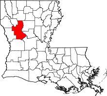 | |
| Town | ||
| Villages | ||
| CDPs | ||
| Other unincorporated communities |
| |
| Footnotes | ‡This populated place also has portions in an adjacent county or counties | |