Banihal
| Banihal बनिहाल بانہال (Devgol) | |
|---|---|
| city | |
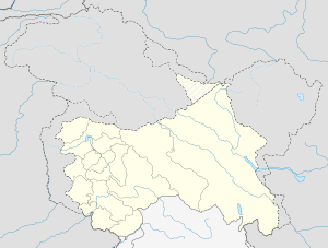 Banihal  Banihal Location in Jammu and Kashmir, India | |
| Coordinates: 33°25′N 75°12′E / 33.42°N 75.2°ECoordinates: 33°25′N 75°12′E / 33.42°N 75.2°E | |
| Country |
|
| State | Jammu and Kashmir |
| District | Ramban |
| Elevation | 1,666 m (5,466 ft) |
| Population (2011) | |
| • Total | 3,900 |
| Languages | |
| • Official | Urdu |
| Time zone | IST (UTC+5:30) |
| Pincode | 182146 |
| Vehicle registration | JK19 |
Banihal (Urdu:بانہال)is a town and a notified area committee in Ramban district in the Indian state of Jammu and Kashmir. "Banihal" means blizzard in Kashmiri language.[1] In some older texts it has also been referred to as 'Devgol' (The abode of mystical giants). It has an average elevation of 1,666 m (5,466 ft).It is a rural and a hilly area with Kamirwah being one of the most spectacular hills. It is located about 35 km (22 mi) away from Qazigund of Anantnag district on NH 1A highway. However, the distance between Banihal and Qazigund is only 18 km by train on the new railway line which is much shorter than the road.Population of Banihal is mostly Muslim (over 95%).The most common language spoken in the region is Kashmiri, Urdu and English being other familiar languages.
Etymology
"Banihal" means blizzard in Kashmiri language.Another view regarding the origin of the name of the place is that the word 'Banihal' has actually been derived from two kashmiri words viz ' bah ' meaning twelve and ' nallhe ' meaning a rivulet.Twelve rivulets signifying the various brooks flowing through the area and eventually joining the small local river called Nalla bischlari.There is a yet another school of thought amongst the locals and some scholars in which the word banihal is thought of as having a Persian origin."Nihal" in Persian means greenery and hence banihal would imply 'Eternally green'.
Banihal Pass
Banihal Pass At 2,832 m (9,291 ft) elevation,the Pir Panjal mountains connect Banihal with Qazigund on the other side of the mountains. The Pir Panjal mountain range separates the Kashmir valley in the Indian state Jammu and Kashmir from the outer Himalaya and plains to the south. After closure of the Murree-Muzaffarabad-Srinagar road on partition of India in 1947, Banihal pass was the only passage from Jammu to Srinagar after independence until 1956 when Jawahar Tunnel was bored through the Pir Panjal range. The pass is accessible only in summer and remains closed rest of the year due to heavy snow. The Banihal city is divided into 7 wards for which elections are held every 5 years. The Banihal Municipal Committee has population of 3,900 of which 2,453 are males while 1,447 are females as per report released by Census India 2011.
Population of Children with age of 0-6 is 388 which is 9.95% of total population of Banihal (MC). In Banihal Municipal Committee, Female Sex Ratio is of 590 against state average of 889. Moreover Child Sex Ratio in Banihal is around 902 compared to Jammu and Kashmir state average of 862. Literacy rate of Banihal city is 83.77% higher than state average of 67.16%. In Banihal, Male literacy is around 91.33% while female literacy rate is 70.31%.
Banihal Municipal Committee has total administration over 645 houses to which it supplies basic amenities like water,electricity and sewage management. It is also authorized to build roads within Municipal Committee limits and impose taxes on properties coming under its jurisdiction.
Banihal Road Tunnels
Existing road tunnel
A 2.5 km (1.6 mi) long tunnel at elevation of 2,194 m (7,198 ft) through Pir Panjal mountain under the Banihal pass connects Banihal with Qazigund on the other side of the mountain. The tunnel named Jawahar tunnel after the first Prime Minister of India was constructed in early 1950s and commissioned in December 1956 to ensure snow-free passage throughout the year. However, it remains closed for a few weeks in winter due to snow avalanches. It was designed for 150 vehicles per day in either direction but now used by more than 7,000 vehicles per day in both directions.[2] Therefore a new wider and longer tunnel has been planned at a lower elevation.
Jawahar tunnel is maintained by Border Road Organisation (BRO) of the Indian army and guarded 24x7 by the CRPF (Central Reserve Police Force), which also monitors it by CCTVs as the tunnel is vital for the Kashmir valley. The tunnel used to be closed to civilian traffic from midnight to 8 a.m. until 2009. Now it is open 24 hours a day.
New double road tunnel
Construction of a new 8.45 km (5.25 mi) long Banihal-Qazigund road tunnel started in 2011 to widen NH 1A to four lanes. It is a double tube tunnel consisting of two parallel tunnels - one for each direction of travel. Each tunnel is 7 metre wide tunnel and has two lanes of road. The two tunnels are interconnected by a passage every 500 metres for maintenance and emergency evacuation. The tunnel will have forced ventilation for extracting smoke and stale air and infusing fresh air. It will have state of the art monitoring and control systems for security.
The new tunnel's average elevation at 1,790 m (5,870 ft) is 400 metre lower than the existing Jawahar tunnel's elevation and would reduce the road distance between Banihal and Qazigund by 30 km (19 mi). The new tunnel would also be less prone to snow avalanche as it will be at a lower elevation. The vehicles will have to pay toll tax to use the tunnel.
As of May 2016, 7.2km of the 8.5km had been excavated.[3]
Banihal Rail Tunnel
A new 11.215 km (7 mile) long Banihal-Qazigund tunnel (also known as Pir Panjal railway tunnel) for the Kashmir Railway line connecting Bichleri Valley of Banihal with Qazigund area of Kashmir Valley has been constructed. The tunnel is 8.40 m wide with a height of 7.39 m. There is a three metre wide road along the length of the tunnel for the maintenance of railway tracks and emergency relief. The boring was completed in October 2011, its lining and laying of rail tracks was completed in the next one year and trial run commenced at the end of 2012. Commercial runs started from 27 June 2013 reducing the distance between Quazigund and Banihal by 17 km (from 35 km by road to 17.5 km by train).[4]
The tunnel’s average elevation at 1,760 m (5,770 ft) is 440 m (1,440 ft) below the existing road tunnel.[5] The rail tunnel will facilitate transportation during winters when inclement weather forces closure of the road tunnel and Srinagar-Jammu highway. Pir Panjal Railway Tunnel is India's longest and Asia's third longest railway tunnel (28 km long Taihang Tunnel in China is the longest and 21 km long Wushaoling Tunnel in Gansu, China is the second longest).
The north portal of the Banihal railway tunnel is at 33°33′42″N 75°11′56″E / 33.5617942°N 75.1988626°E and the south portal is at 33°27′48″N 75°11′38″E / 33.463203°N 75.193992°E.
Banihal railway station
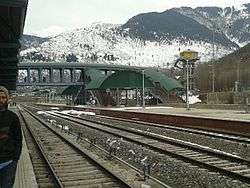
Banihal railway station is situated at 1,702 m (5,584 ft) above mean sea level. It was commissioned on 26 June 2013 and passenger trains run from Banihal to Qazigund. The railway network in Kashmir from Banihal to Baramulla is now 137 km. Five trains run daily from Banihal to Baramulla. Until the 148 km Katra-Banihal section of Kashmir railway gets constructed, expected to be completed by 2018, people can travel from Jammu Tawi or Udhampur to Banihal by road and take the train from Banihal to Srinagar.
Demographics
As of 2001 India census,[6] Banihal had a population of 2,729. Males constitute 57% of the population and females 43%. Banihal Town Muslim 71.51%, Hindu 27.49%,
Regions and Valleys
The Mountain regions, highland pockets and mini valleys that are part of the entire Banihal region consist of the following areas:
- Pugal:It is the mountainous region drained by Pugal stream a tributary of Bischlari that comes from the eastern mountains of Banihal.The area is rugged and quite mountainous.The people are hardy.Pugali is the dialect spoken by some 12000 inhabitants.Cattle rearing is main occupation of the people,Maize cultivated on sloppy land is the main staple crop.
- Peeristan or Paristan:The area beyond Pogal is called Paristan or Peeristan,which literally means the abode of Fairies or Saintly person of high miraculous powers.The area is rugged and mountainous and very scarcely populated.It also includes the Neel mountainous region.
- Mahu-Mangat: In Banihal there is another mountainous region towards west side, drained by the rivulet of the same name, another tributary of Bishlari. The area is rugged but full of long grassy slopes that attracted people rearing goat,sheep and cattle in the region, who inhabit it. Maize is the stable food cultivated on sloppy lands. Milk and Ghee is the main produce.
- Ramban: The old name of the place was Kamban meaning the place of Kam trees, but when Maharaja Gulab Singh passed through the place around 1819-20, he named it as Ramban,the place was not of much historical importance,except that it was situated on the traditional mountain route between Jammu and the valley, with most suitable point of crossing of the mighty Chenab River, and with a lowest height of pass on the Pantsal range. Today it is the headquarters of a newly constituted District of the same name, and the site of a 900 Megawatt hydroelectric Project of Baglihar Dam, and an important station on the NH 1A
List of Some Hamlets in the region:
- Chareel
- Tethar
- Kaskoot
- Foharwagan
- Zeinhal
- Asher
- Lambar
- Haadbaer
- Krawa
- Gund
- Holeun
- Bankoot
- Ukarhal
- Neel
- Chamalwaas
- Chanjloo
- Dooligam
- Fagwa
Historical References
According to the Rajatarangini (C-1000-1011 AD) – a chronicle that recorded the history of Kashmir and its Kingdoms and Kings, Banihal was known as ‘Vishalta’ in the 11th Century and was a very narrow mountain valley which was used as an escape route by revolting Princes, rebel Chieftains, and even conspirators from Kashmir. In the 11th Century, a small fort called ‘Bansalla’ also existed below the old Banihal Pass. The Bansalla Fort belonged to the 11th Century ruler of Vishalta the Khasa Lord Bhagika who was the son- in-law of the Lord of Buddha Tikka. Pandit Sahib Ram, who in his book “Tirthas” copies Abu'l-Fazl ibn Mubarak's notes, metamorphosizes the Sanskrit name of village Banihal from Bhanusita or Bhanusata i.e rocks of the Sun or land of the Sun. Aurel Stein on his commentary on Kalhana's Rajatarangini describes the place differently. According to him, Visalata or Banihal must be identified with the valley drained by rivulet Bischlari.
Gallery

-
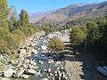
The local Rivulet Bischlari
-
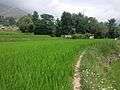
paddy fields in a local hamlet
-

The Pir Panjal range as seen from Foharwagan
See also
References
- ↑ Encyclopædia Britannica Online. "Banihal Pass.". Archived from the original on 4 June 2009. Retrieved 2009-06-17.
- ↑ http://mod.nic.in/Samachar/mar5/html/army.htm
- ↑ http://www.governancenow.com/news/regular-story/tunnels-hope-in-valley
- ↑ http://indiatoday.intoday.in/story/indian-railways-pir-panjal-tunnel-kashmir-valley-asia-second-longest-tunnel/1/239901.html
- ↑ http://usbrl.org/aboutus.php
- ↑ "Census of India 2001: Data from the 2001 Census, including cities, villages and towns (Provisional)". Census Commission of India. Archived from the original on 2004-06-16. Retrieved 2008-11-01.
- ↑ http://blogs.halabol.com/2013/03/07/banihal-gate-way-kashmir