Breckland District
| Breckland District | |
|---|---|
| Non-metropolitan district | |
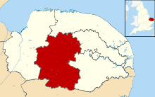 Breckland shown within Norfolk | |
| Sovereign state | United Kingdom |
| Constituent country | England |
| Region | East of England |
| Non-metropolitan county | Norfolk |
| Status | Non-metropolitan district |
| Admin HQ | East Dereham |
| Incorporated | 1 April 1974 |
| Government | |
| • Type | Non-metropolitan district council |
| • Body | Breckland Council |
| • Leadership | Leader & Cabinet (Conservative) |
| • MPs |
George Freeman Elizabeth Truss |
| Area | |
| • Total | 399.7 sq mi (1,035.1 km2) |
| Area rank | 16th (of 326) |
| Population (mid-2014 est.) | |
| • Total | 133,986 |
| • Rank | 158th (of 326) |
| • Density | 340/sq mi (130/km2) |
| • Ethnicity | 98.5% White |
| Time zone | GMT (UTC0) |
| • Summer (DST) | BST (UTC+1) |
| ONS code |
33UB (ONS) E07000143 (GSS) |
| OS grid reference | TG018081 |
| Website |
www |
Breckland District is a local government district in Norfolk, England. Its council is based in East Dereham. The population of the Local Authority District at the 2011 Census was 130,491.[1]
Breckland District derives its name from the Breckland landscape region, a gorse-covered sandy heath of south Norfolk and north Suffolk. The term Breckland is ancient, and is found as early as the 13th century in the form Brakelond.
History
Breckland District was formed on 1 April 1974 by the merger of the Borough of Thetford, East Dereham Urban District, Swaffham Urban District, Wayland Rural District, Mitford and Launditch Rural District, and Swaffham Rural District.
Composition
The district is entirely parished, and is made up of 113 civil parishes. At the time of the 2001 census, the district had an area of 1,305 km2 (504 sq mi), with a population of 121,418 in 50,715 households.[2]
The district contains the following civil parishes:
- Ashill, Attleborough
- Banham, Bawdeswell, Beachamwell, Beeston with Bittering, Beetley, Besthorpe, Billingford, Bintree, Blo' Norton, Bradenham, Brettenham, Bridgham, Brisley, Bylaugh
- Carbrooke, Caston, Cockley Cley, Colkirk, Cranwich, Cranworth, Croxton
- Didlington, Dereham
- East Tuddenham, Elsing
- Foulden, Foxley, Fransham
- Garboldisham, Garvestone, Gateley, Gooderstone, Great Cressingham, Great Dunham, Great Ellingham, Great Hockham, Gressenhall, Griston, Guist
- Hardingham, Harling, Hilborough, Hockering, Hoe, Holme Hale, Horningtoft
- Ickburgh
- Kempstone, Kenninghall, Kilverstone
- Lexham, Litcham, Little Cressingham, Little Dunham, Little Ellingham, Longham, Lynford, Lyng
- Mattishall, Merton, Mileham, Mundford
- Narborough, Narford, Necton, New Buckenham, Newton by Castle Acre, North Elmham, North Lopham, North Pickenham, North Tuddenham
- Old Buckenham, Ovington, Oxborough
- Quidenham
- Riddlesworth, Rocklands, Rockland St Peter, Roudham and Larling, Rougham
- Saham Toney, Scarning, Scoulton, Shipdham, Shropham, Snetterton, South Acre, South Lopham, South Pickenham, Sparham, Sporle with Palgrave, Stanfield, Stanford, Stow Bedon, Sturston, Swaffham, Swanton Morley,
- Thetford, Thompson, Tittleshall, Tottington, Twyford
- Watton, Weasenham All Saints, Weasenham St. Peter, Weeting-with-Broomhill, Wellingham, Wendling, Whinburgh and Westfield, Whissonsett, Wretham
- Yaxham
References
- ↑ "Local Authority District population 2011". Neighbourhood Statistics. Office for National Statistics. Retrieved 26 July 2016.
- ↑ Office for National Statistics & Norfolk County Council (2001). Census population and household counts for unparished urban areas and all parishes. Retrieved 2 December 2005.
External links
- Diss Express - website of local newspaper covering part of district
| Boroughs or districts | |
|---|---|
| Major settlements |
|
| Topics | |
Coordinates: 52°38′N 0°59′E / 52.633°N 0.983°E