Carlton, Kansas
| Carlton, Kansas | |
|---|---|
| City | |
 Location within Dickinson County and Kansas | |
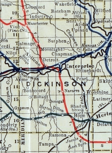
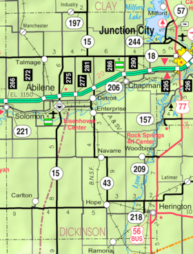 KDOT map of Dickinson County (legend) | |
| Coordinates: 38°41′14″N 97°17′36″W / 38.68722°N 97.29333°WCoordinates: 38°41′14″N 97°17′36″W / 38.68722°N 97.29333°W[1] | |
| Country | United States |
| State | Kansas |
| County | Dickinson |
| Government | |
| • Type | Mayor–Council |
| • Mayor | Darren Rader |
| Area[2] | |
| • Total | 0.17 sq mi (0.44 km2) |
| • Land | 0.17 sq mi (0.44 km2) |
| • Water | 0 sq mi (0 km2) |
| Elevation[1] | 1,316 ft (401 m) |
| Population (2010)[3] | |
| • Total | 42 |
| • Estimate (2012[4]) | 42 |
| • Density | 250/sq mi (95/km2) |
| Time zone | Central (CST) (UTC-6) |
| • Summer (DST) | CDT (UTC-5) |
| FIPS code | 20-10675 [1][5] |
| GNIS ID | 0476970 [1][6] |
Carlton is a city in Dickinson County, Kansas, United States.[1] As of the 2010 census, the city population was 42.[7]
History
Early history
For many millennia, the Great Plains of North America was inhabited by nomadic Native Americans. From the 16th century to 18th century, the Kingdom of France claimed ownership of large parts of North America. In 1762, after the French and Indian War, France secretly ceded New France to Spain, per the Treaty of Fontainebleau.
19th century
In 1802, Spain returned most of the land to France. In 1803, most of the land for modern day Kansas was acquired by the United States from France as part of the 828,000 square mile Louisiana Purchase for 2.83 cents per acre.
In 1854, the Kansas Territory was organized, then in 1861 Kansas became the 34th U.S. state. In 1857, Dickinson County was established within the Kansas Territory, which included the land for modern day Carlton.
Carlton was a station and shipping point on the Missouri Pacific Railroad.[8]
A post office was opened in Carlton in 1872, and remained in operation until it was discontinued in 1995.[9]
Geography
Carlton is located at 38°41′12″N 97°17′38″W / 38.68667°N 97.29389°W (38.686786, -97.294015).[10] According to the United States Census Bureau, the city has a total area of 0.17 square miles (0.44 km2), all of it land.[2]
Demographics
| Historical population | |||
|---|---|---|---|
| Census | Pop. | %± | |
| 1890 | 121 | — | |
| 1930 | 138 | — | |
| 1940 | 101 | −26.8% | |
| 1950 | 76 | −24.8% | |
| 1960 | 78 | 2.6% | |
| 1970 | 40 | −48.7% | |
| 1980 | 49 | 22.5% | |
| 1990 | 39 | −20.4% | |
| 2000 | 38 | −2.6% | |
| 2010 | 42 | 10.5% | |
| Est. 2015 | 42 | [11] | 0.0% |
| U.S. Decennial Census | |||
2010 census
As of the census[3] of 2010, there were 42 people, 16 households, and 14 families residing in the city. The population density was 247.1 inhabitants per square mile (95.4/km2). There were 20 housing units at an average density of 117.6 per square mile (45.4/km2). The racial makeup of the city was 100.0% White.
There were 16 households of which 37.5% had children under the age of 18 living with them, 81.3% were married couples living together, 6.3% had a female householder with no husband present, and 12.5% were non-families. 12.5% of all households were made up of individuals and 6.3% had someone living alone who was 65 years of age or older. The average household size was 2.63 and the average family size was 2.86.
The median age in the city was 46.5 years. 28.6% of residents were under the age of 18; 0.0% were between the ages of 18 and 24; 19.1% were from 25 to 44; 26.1% were from 45 to 64; and 26.2% were 65 years of age or older. The gender makeup of the city was 52.4% male and 47.6% female.
2000 census
As of the census[5] of 2000, there were 38 people, 16 households, and 11 families residing in the city. The population density was 232.0 people per square mile (91.7/km²). There were 20 housing units at an average density of 122.1 per square mile (48.3/km²). The racial makeup of the city was 100.00% White.
There were 16 households out of which 31.3% had children under the age of 18 living with them, 62.5% were married couples living together, 6.3% had a female householder with no husband present, and 31.3% were non-families. 31.3% of all households were made up of individuals and 6.3% had someone living alone who was 65 years of age or older. The average household size was 2.38 and the average family size was 2.91.
In the city the population was spread out with 23.7% under the age of 18, 5.3% from 18 to 24, 34.2% from 25 to 44, 23.7% from 45 to 64, and 13.2% who were 65 years of age or older. The median age was 39 years. For every 100 females there were 100.0 males. For every 100 females age 18 and over, there were 107.1 males.
The median income for a household in the city was $33,125, and the median income for a family was $33,125. Males had a median income of $22,188 versus $13,750 for females. The per capita income for the city was $9,750. None of the population and none of the families were below the poverty line.
Education
Primary and secondary education
Carlton is part of Unified School District 473.[12][13]
See also
Further reading
- Carlton Area History: Carlton - Elmo - Holland, Dickinson County, Kansas; Carlton Book Committee; Bell Books; 1995.
References
- 1 2 3 4 5 Geographic Names Information System (GNIS) details for Carlton, Kansas; United States Geological Survey (USGS); October 13, 1978.
- 1 2 "US Gazetteer files 2010". United States Census Bureau. Archived from the original on 2012-07-14. Retrieved 2012-07-06.
- 1 2 "American FactFinder". United States Census Bureau. Retrieved 2012-07-06.
- ↑ "Population Estimates". United States Census Bureau. Archived from the original on 2013-06-17. Retrieved 2013-05-29.
- 1 2 "American FactFinder". United States Census Bureau. Archived from the original on 2013-09-11. Retrieved 2008-01-31.
- ↑ "US Board on Geographic Names". United States Geological Survey. 2007-10-25. Retrieved 2008-01-31.
- ↑ "2010 City Population and Housing Occupancy Status". U.S. Census Bureau. Archived from the original on July 21, 2011. Retrieved March 6, 2011.
- ↑ Blackmar, Frank Wilson (1912). Kansas: A Cyclopedia of State History, Embracing Events, Institutions, Industries, Counties, Cities, Towns, Prominent Persons, Etc. Standard Publishing Company. p. 288.
- ↑ "Kansas Post Offices, 1828-1961 (archived)". Kansas Historical Society. Archived from the original on September 9, 2013. Retrieved 8 June 2014.
- ↑ "US Gazetteer files: 2010, 2000, and 1990". United States Census Bureau. 2011-02-12. Retrieved 2011-04-23.
- ↑ "Annual Estimates of the Resident Population for Incorporated Places: April 1, 2010 to July 1, 2015". Retrieved July 2, 2016.
- ↑ USD 473
- ↑ Kansas School District Boundary Map Archived July 21, 2011, at the Wayback Machine.
External links
| Wikimedia Commons has media related to Carlton, Kansas. |
- City
- Schools
- USD 473, local school district
- USD 473 School District Boundary Map, KDOT
- Historical
- Historic Images of Carlton, Special Photo Collections at Wichita State University Library
- Maps
- Carlton City Map, KDOT
Municipalities and communities of Dickinson County, Kansas, United States | ||
|---|---|---|
| Cities | 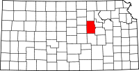 | |
| CDPs | ||
| Unincorporated communities | ||
| Townships | ||
| Footnotes | ‡This populated place also has portions in an adjacent county or counties | |