Solomon, Kansas
| Solomon, Kansas | |
|---|---|
| City | |
 Location within Dickinson County and Kansas | |
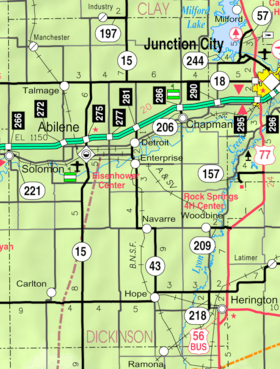 KDOT map of Dickinson County (legend) | |
| Coordinates: 38°55′7″N 97°22′11″W / 38.91861°N 97.36972°WCoordinates: 38°55′7″N 97°22′11″W / 38.91861°N 97.36972°W | |
| Country | United States |
| State | Kansas |
| Counties | Dickinson, Saline |
| Government | |
| • Type | Mayor–Council |
| Area[1] | |
| • Total | 0.85 sq mi (2.20 km2) |
| • Land | 0.85 sq mi (2.20 km2) |
| • Water | 0 sq mi (0 km2) |
| Elevation | 1,171 ft (357 m) |
| Population (2010)[2] | |
| • Total | 1,095 |
| • Estimate (2014)[3] | 1,061 |
| • Density | 1,300/sq mi (500/km2) |
| Time zone | Central (CST) (UTC-6) |
| • Summer (DST) | CDT (UTC-5) |
| ZIP code | 67480 |
| Area code(s) | 785 |
| FIPS code | 20-66275 [4] |
| GNIS feature ID | 0476660 [5] |
| Website | City Website |
Solomon is a city in Dickinson and Saline counties in the U.S. state of Kansas. As of the 2010 census, the city population was 1,095.[6] It is located approximately 6 miles west of Abilene.
History
The first post office at Solomon was established in October, 1860.[7]
Solomon was founded in 1866.[8] It was named from its position near the mouth of the Solomon River.[9] Solomon was incorporated as a city in 1871.[10]
Geography
Solomon is located at 38°55′7″N 97°22′11″W / 38.91861°N 97.36972°W (38.918578, -97.369665).[11] According to the United States Census Bureau, the city has a total area of 0.85 square miles (2.20 km2), all of it land.[1]
Demographics
| Historical population | |||
|---|---|---|---|
| Census | Pop. | %± | |
| 1880 | 618 | — | |
| 1890 | 839 | 35.8% | |
| 1900 | 817 | −2.6% | |
| 1910 | 949 | 16.2% | |
| 1920 | 1,071 | 12.9% | |
| 1930 | 1,032 | −3.6% | |
| 1940 | 872 | −15.5% | |
| 1950 | 834 | −4.4% | |
| 1960 | 1,008 | 20.9% | |
| 1970 | 973 | −3.5% | |
| 1980 | 1,018 | 4.6% | |
| 1990 | 939 | −7.8% | |
| 2000 | 1,072 | 14.2% | |
| 2010 | 1,095 | 2.1% | |
| Est. 2015 | 1,054 | [12] | −3.7% |
| U.S. Decennial Census | |||
The Saline County portion of Solomon is part of the Salina Micropolitan Statistical Area.[13]
2010 census
As of the census[2] of 2010, there were 1,095 people, 433 households, and 295 families residing in the city. The population density was 1,288.2 inhabitants per square mile (497.4/km2). There were 465 housing units at an average density of 547.1 per square mile (211.2/km2). The racial makeup of the city was 96.1% White, 0.3% Native American, 0.2% Asian, 0.9% from other races, and 2.6% from two or more races. Hispanic or Latino of any race were 2.1% of the population.
There were 433 households of which 35.8% had children under the age of 18 living with them, 52.0% were married couples living together, 11.1% had a female householder with no husband present, 5.1% had a male householder with no wife present, and 31.9% were non-families. 27.0% of all households were made up of individuals and 12.7% had someone living alone who was 65 years of age or older. The average household size was 2.53 and the average family size was 3.08.
The median age in the city was 36.4 years. 27.7% of residents were under the age of 18; 8% were between the ages of 18 and 24; 27.8% were from 25 to 44; 22.6% were from 45 to 64; and 13.8% were 65 years of age or older. The gender makeup of the city was 49.5% male and 50.5% female.
2000 census
As of the census[4] of 2000, there were 1,072 people, 416 households, and 302 families residing in the city. The population density was 1,634.8 people per square mile (627.1/km²). There were 452 housing units at an average density of 689.3 per square mile (264.4/km²). The racial makeup of the city was 98.32% White, 0.19% Native American, 0.09% Asian, 0.93% from other races, and 0.47% from two or more races. Hispanic or Latino of any race were 2.15% of the population.
There were 416 households out of which 38.9% had children under the age of 18 living with them, 57.0% were married couples living together, 12.5% had a female householder with no husband present, and 27.2% were non-families. 23.3% of all households were made up of individuals and 10.6% had someone living alone who was 65 years of age or older. The average household size was 2.56 and the average family size was 3.01.
In the city the population was spread out with 31.5% under the age of 18, 6.0% from 18 to 24, 29.8% from 25 to 44, 20.8% from 45 to 64, and 11.9% who were 65 years of age or older. The median age was 36 years. For every 100 females there were 100.7 males. For every 100 females age 18 and over, there were 90.2 males.
The median income for a household in the city was $40,469, and the median income for a family was $48,203. Males had a median income of $34,926 versus $19,063 for females. The per capita income for the city was $16,800. About 8.6% of families and 13.6% of the population were below the poverty line, including 19.3% of those under age 18 and 9.0% of those age 65 or over.
Economy
Solomon Corporation is the largest employer in Solomon.[14] It is the largest rebuilder of oil-filled transformers in the United States.[15]
Education
Primary and secondary education
Solomon is part of Unified School District 393.[16][17][18]
Notable people
- Archie Butcher, head college football coach of Ottawa University
- Algo Henderson, president of Antioch College
- Kenneth McLeod, Canadian politician
- Seymour Stedman, lawyer and Socialist candidate for Vice-President of the United States
See also
Further reading
References
- 1 2 "US Gazetteer files 2010". United States Census Bureau. Retrieved 2012-07-06.
- 1 2 "American FactFinder". United States Census Bureau. Retrieved 2012-07-06.
- ↑ "Annual Estimates of the Resident Population for Incorporated Places: April 1, 2010 to July 1, 2014". Retrieved June 4, 2015.
- 1 2 "American FactFinder". United States Census Bureau. Retrieved 2008-01-31.
- ↑ "US Board on Geographic Names". United States Geological Survey. 2007-10-25. Retrieved 2008-01-31.
- ↑ "2010 City Population and Housing Occupancy Status". U.S. Census Bureau. Retrieved March 6, 2011.
- ↑ "Kansas Post Offices, 1828-1961, page 2 (archived)". Kansas Historical Society. Archived from the original on September 9, 2013. Retrieved 8 June 2014.
- ↑ Kansas State Historical Society (1916). Biennial Report of the Board of Directors of the Kansas State Historical Society. Kansas State Printing Plant. p. 176.
- ↑ Heim, Michael (2007). Exploring Kansas Highways. p. 39.
- ↑ Blackmar, Frank Wilson (1912). Kansas: A Cyclopedia of State History, Volume 2. Standard Publishing Company. p. 715.
- ↑ "US Gazetteer files: 2010, 2000, and 1990". United States Census Bureau. 2011-02-12. Retrieved 2011-04-23.
- ↑ "Annual Estimates of the Resident Population for Incorporated Places: April 1, 2010 to July 1, 2015". Retrieved July 2, 2016.
- ↑ Nussle, Jim (2008-11-20). "Micropolitan Statistical Areas" (PDF). List 1-9. Office of Management and Budget, Executive Office of the President. p. 97. Retrieved 2010-04-02.
- ↑ List of Top Employers in Solomon.
- ↑ Solomon Corporation - About Us.
- ↑ USD 393
- ↑ Kansas School District Boundary Map
- ↑ Saline County School District Map
External links
| Wikimedia Commons has media related to Solomon, Kansas. |
- City
- Schools
- USD 393, local school district
- Historical
- Historic Images of Solomon, Special Photo Collections at Wichita State University Library
- Solomon Valley Tribune - An All-Volunteer Newspaper on YouTube, from Hatteberg's People on KAKE TV news
- Maps
- Solomon City Map, KDOT
Municipalities and communities of Dickinson County, Kansas, United States | ||
|---|---|---|
| Cities | 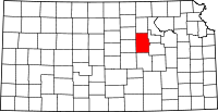 | |
| CDPs | ||
| Unincorporated communities | ||
| Townships | ||
| Footnotes | ‡This populated place also has portions in an adjacent county or counties | |
Municipalities and communities of Saline County, Kansas, United States | ||
|---|---|---|
| Cities |  | |
| CDPs | ||
| Unincorporated communities | ||
| Townships |
| |
| Footnotes | ‡This populated place also has portions in an adjacent county or counties | |