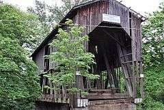
Chambers Covered Bridge
|
Chambers Bridge | |
 | |
  | |
| Location | S. River Rd., Cottage Grove, Oregon |
|---|---|
| Coordinates | 43°47′34″N 123°4′7″W / 43.79278°N 123.06861°W |
| Area | 0.1 acres (0.040 ha) |
| Built | 1925 |
| Architectural style | Howe Truss |
| MPS | Oregon Covered Bridges TR |
| NRHP Reference # | 79002081[1] |
| Added to NRHP | November 29, 1979 |
The Chambers Covered Bridge is a covered bridge located in Cottage Grove, Oregon, United States. It is 78 feet (24 m) long and spans the Coast Fork Willamette River. It was built in 1925 to carry rail traffic hauling logs from the Lorane Valley to the J.H. Chambers Mill,[2] a lumber mill which was located on an area between South Highway 99 and the Coast Fork Willamette River. The mill closed in the 1950s after a second fire burned the mill down. The railroad tracks were removed and the bridge was left. The mill property is now being developed as a housing development called Riverwalk. The Chambers Covered Railroad Bridge is the only remaining fully covered railroad bridge west of the Mississippi River.[3]
Construction
It is a Howe truss design.[2]
Preservation
In FY 2008, The National Historic Covered Bridge Preservation Program, administered by the Federal Highway Administration, awarded a grant of $1,315,370 to the City of Cottage Grove for the rehabilitation of the Chambers Covered Bridge, one of seven covered bridges in Oregon that received grants the same period.[4]
Reconstruction
Chambers Covered Bridge was removed in 2010 and replaced with a carefully constructed bridge that is identical to the previous one. The new bridge is now open for pedestrians.[5]

See also
- List of bridges on the National Register of Historic Places in Oregon
- List of Oregon covered bridges
References
- ↑ National Park Service (2009-03-13). "National Register Information System". National Register of Historic Places. National Park Service.
- 1 2 "Chambers Covered Bridge". City of Cottage Grove, Oregon. Retrieved 2011-10-21.
- ↑ "Chambers Covered Bridge". Lane County, Oregon. Retrieved 2011-10-21.
- ↑ "National Historic Covered Bridge Preservation Program". Retrieved 2009-01-28.
- ↑
External links
| Wikimedia Commons has media related to Chambers Covered Bridge. |
Coordinates: 43°47′22″N 123°04′11″W / 43.78937°N 123.06968°W
| Topics | |
|---|---|
| Lists by states |
|
| Lists by insular areas | |
| Lists by associated states | |
| Other areas | |
| |