Chūō-ku, Niigata
| Chuo-ku, Niigata 新潟市中央区 | |
|---|---|
| Ward of Niigata | |
| 新潟市中央区 | |
|
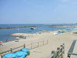
Sekiyahama Beach | |
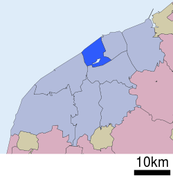 Location of Chūō-ku in Niigata City | |
 Chuo-ku, Niigata
| |
| Coordinates: 37°54′58.3″N 139°02′11″E / 37.916194°N 139.03639°ECoordinates: 37°54′58.3″N 139°02′11″E / 37.916194°N 139.03639°E | |
| Country | Japan |
| Region | Kōshin'etsu, Hokuriku (Chūbu) |
| Prefecture | Niigata |
| City | Niigata |
| Area | |
| • Total | 37.75 km2 (14.58 sq mi) |
| Population (April 1, 2016) | |
| • Total | 183,820 |
| • Density | 4,860/km2 (12,600/sq mi) |
| Time zone | Japan Standard Time (UTC+9) |
| Postal | 951-8550 |
| Address | Gakko-cho-dori 1-602-1, Chuo-ku, Niigata-shi, Niigata-ken |
| Telephone Number | 025-223-1000 |
| Website |
www |
Chūō-ku (中央区 Chūō-ku) is one of the eight wards of Niigata City, Niigata Prefecture, in the Hokuriku region of Japan. It comprises much of the city centre. As of 1 June 2016, the ward had an estimated population of 183,820 and a population density of 4,860 persons per km². Its total area was 37.75 square kilometres (14.58 sq mi).
Geography
Chūō-ku is located in the approximate centre of Niigata City, bounded by the Sea of Japan to the north and the Nihonkai-Tōhoku Expressway to the south. The area comprises the old city as well as the Sonoki (曽野木), Nuttari (沼垂), Toyano (鳥屋野) and the Yamagata (山潟) districts.
Neighboring municipalities/wards
Neighborhoods
Central Business District
Chūō-ku is the heart of Niigata in terms of economic and political importance. The City Office is located here along with several central government and prefectural agencies. Japan's national broadcaster NHK has its prefectural TV station and radio station in Chūō-ku. There are several company head offices based in the district. It is also the site of old Niigata City which extends from Niigata Station downtown to Bandai Bridge and Furumachi.
Furumachi
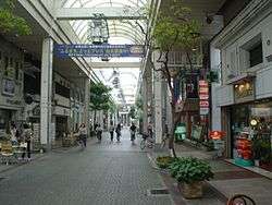
Furumachi in Niigata city is located on left bank of Shinano River across Bandai Bridge. It lies on Niigata Island and faces the Sea of Japan. The area has been developed around Masaya-koji, which is a wide six-lane thoroughfare connecting Furumachi with Niigata Station. Furumachi has business districts as well as several historic parts. Narrow alleyways and streets criss cross beneath the modern office buildings. The historic Honcho market is also here. Much of the area contains modern buildings. This is because Furumachi was rebuilt after an earthquake devastated this part of eastern Niigata in 1964. This is in marked contrast with areas on the west side of the river which still retain traditional-looking streets containing older houses.
History

The area of present-day Chūō-ku was part of ancient Echigo Province, and developed as a port town for Nagaoka Domain under the Edo period Tokugawa Shogunate. Niigata was one of the ports opened to foreign trade by the 1858 Harris Treaty. Modern Niigata city was created with the establishment of the municipalities system on April 1, 1889. The Hokuetsu Railway commented Niigata to Tokyo in 1897, and the first Bandai Bridge across the Shinano River was completed in 1908, shortly before the city was destroyed by a fire. The city escaped serious damage in World War II; however, much of the city burned down in a fire in 1955 and again suffered from damage in the 1964 Niigata earthquake.
Niigata became a government-designated city on April 1, 2007 and was divided into wards, with the new Chūō Ward consisting of much of the central business portion of the city.
Education
Universities
- Niigata University (Asahimachi Campus / Nishi-Ohata Campus)
- Niigata Seiryo University
- The Nippon Dental University (Niigata)
Secondary education
Chūō-ku has five public high school operated by the Niigata Prefectural Board of Education, two public high schools operated by the Niigata City Board of Education, three private high schools and one private combined middle school/high school.The ward also has ten public middle schools.
Transportation
Railway
- JR East - Jōetsu Shinkansen
- JR East - Shin'etsu Main Line
- JR East - Hakushin Line
- JR East - Echigo Line
Transit bus
- Niigata City Loop Bus[1][2]
- Transit bus operated by Niigata Kotsu[3]
- BRT "Bandai-bashi Line" : Niigata Sta.—Bandai Bridge—Furumachi—City office—Hakusan Sta.—(Aoyama)
- C* : for Central Niigata[4]
- S* : for South Niigata [5]
- W* : for West Niigata[6]
- E* : for East Niigata[7]
- "Sado-Kisen Line" : Niigata Sta.—Toki Messe—Sado Kisen Ferry Terminal
Highways
- Japan National Route 7
- Japan National Route 8
- Japan National Route 49
- Japan National Route 113
- Japan National Route 116
- Japan National Route 402
Ports
- Sado Kisen Ferry Terminal
Water Shuttle
- Shinanogawa Water Shuttle: MINATOPIA - Toki Messe - Bandai Bridge - Bandai City - Niigata Prefectural office - (FURUSATO VILLAGE)
Local attractions

West side of the Shinano River
- Niigata City History Museum (MINATOPIA)
- The Niigata Saitou Villa
- Hakusan Park
- Niigata-City Performing Arts Center (Ryutopia)
- Niigata Prefectural Civic Center
- Niigata city Aquarium (Marinepia Nihonkai)
- NEXT21
- Furumachi-dori Shopping Mall
- Honcho-dori Shopping Mall
- Ninjo-Yokocho Shopping Mall
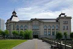 MINATOPIA
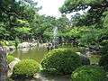 Hakusan Park
 NEXT21 in Furumachi
East side of the Shinano River
- Niigata Station
- Sake Museum Ponshu-kan
- Bandai City shopping district
- Niigata Manga & Animation Museum
- Niigata Nippo MEDIA SHIP
- Toki Messe
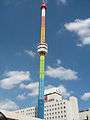 Rainbow Tower, the symbol of Bandai City
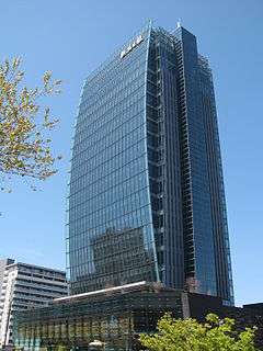 Media Ship
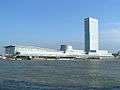 TOKI MESSE (Niigata Convention center)
South side of the Toyanogata Lagoon
 Big Swan Stadium and Toyanogata Lagoon
Events
- Niigata Festival (every August)
- Niigata Comic Market
- Niigata Manga Competition
See also
References
- ↑ Niigata City Loop Bus Map (2016.3- ) (PDF). Niigata City. Retrieved 9 October 2016.
- ↑ Niigata City Loop Bus Timetables (2016.3- ) (PDF). Niigata City. Retrieved 9 October 2016.
- ↑ 運行便別時刻表 [Bus Lines and Timetables (2016.3- )] (in Japanese). Niigata Kotsu. Retrieved 9 October 2016.
- ↑ 路線図(中心部) [Bus Map for East Niigata (2016.3- )] (PDF) (in Japanese). Niigata Kotsu. Retrieved 9 October 2016.
- ↑ 路線図(南方面) [Bus Map for East Niigata (2016.3- )] (PDF) (in Japanese). Niigata Kotsu. Retrieved 9 October 2016.
- ↑ 路線図(西方面) [Bus Map for East Niigata (2016.3- )] (PDF) (in Japanese). Niigata Kotsu. Retrieved 9 October 2016.
- ↑ 路線図(東方面) [Bus Map for East Niigata (2016.3- )] (PDF) (in Japanese). Niigata Kotsu. Retrieved 9 October 2016.
External links
![]() Media related to Chūō-ku, Niigata at Wikimedia Commons
Media related to Chūō-ku, Niigata at Wikimedia Commons
- Niigata official website (Japanese)
- Niigata Chūō-ku website (Japanese)
- Niigata City Official Tourist Information (multilingual)
- Niigata Pref. Official Travel Guide (multilingual)