Sekikawa, Niigata
| Sekikawa 関川村 | |||
|---|---|---|---|
| Village | |||
|
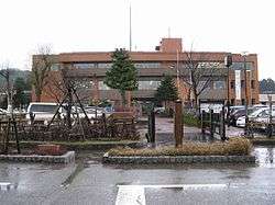
Sekikawa village hall | |||
| |||
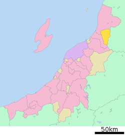 Location of Sekikawa in Niigata | |||
 Sekikawa
| |||
| Coordinates: 38°5′21.8″N 139°33′54.1″E / 38.089389°N 139.565028°ECoordinates: 38°5′21.8″N 139°33′54.1″E / 38.089389°N 139.565028°E | |||
| Country | Japan | ||
| Region | Chūbu (Kōshin'etsu) (Hokuriku) | ||
| Prefecture | NIigata | ||
| District | Iwafune | ||
| Area | |||
| • Total | 299.61 km2 (115.68 sq mi) | ||
| Population (June 2016) | |||
| • Total | 5,743 | ||
| • Density | 19.2/km2 (50/sq mi) | ||
| Time zone | Japan Standard Time (UTC+9) | ||
| Symbols | |||
| • Tree | Maple | ||
| • Flower | Lilium | ||
| Phone number | 0254-64-1441 | ||
| Address | 912 Shimonoseki, Sekikawa-mura, Iwafune-gun, Niigata-ken 959-3265 | ||
| Website |
www | ||


Sekikawa (関川村 Sekikawa-mura) is a village located in Iwafune District, Niigata Prefecture, in the Hokuriku region of Japan. As of 1 June 2016, the village had an estimated population of 5,743 and a population density of 19.2 persons per km². Its total area was 299.61 square kilometres (115.68 sq mi).
Geography
Sekikawa is located in mountainous northeastern Niigata Prefecture, bordered by Yamagata Prefecture to the east.
Surrounding municipalities
History
The area of present-day Sekikawa was part of ancient Echigo Province. The modern village of Sekigawa was established on August 1, 1954.
Economy
The local economy is dominated by agriculture
Education
Sekikawa has one public elementary school and one public middle school. The village does not have a high school.
Transportation
Railway
Highway
Gallery
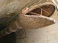 Taishitamonja, the straw serpent
External links
 Media related to Sekikawa, Niigata at Wikimedia Commons
- Sekikawa official website (Japanese)
This article is issued from Wikipedia - version of the 9/4/2016. The text is available under the Creative Commons Attribution/Share Alike but additional terms may apply for the media files.