Murakami, Niigata
| Murakami 村上市 | |||
|---|---|---|---|
| City | |||
|
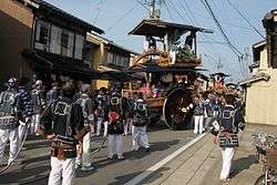
Murakami Taisai Festival | |||
| |||
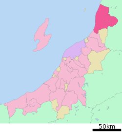 Location of Murakami in Niigata Prefecture | |||
 Murakami
| |||
| Coordinates: 38°13′26.4″N 139°28′48″E / 38.224000°N 139.48000°ECoordinates: 38°13′26.4″N 139°28′48″E / 38.224000°N 139.48000°E | |||
| Country | Japan | ||
| Region | Chūbu (Kōshin'etsu) (Hokuriku) | ||
| Prefecture | NIigata | ||
| Area | |||
| • Total | 1,174.26 km2 (453.38 sq mi) | ||
| Population (June 2016) | |||
| • Total | 61,747 | ||
| • Density | 52.6/km2 (136/sq mi) | ||
| Time zone | Japan Standard Time (UTC+9) | ||
| Symbols | |||
| • Tree | Fagus crenata | ||
| • Flower | Rosa rugosa | ||
| • Bird | Spizaetus nipalensis | ||
| Phone number | 0254-53-2111 | ||
| Address | 1-1, Sannochō, Murakami-shi, Niigata-ken 958-8501 | ||
| Website |
www | ||


Murakami (村上市 Murakami-shi) is a city located in far northern Niigata Prefecture, in the Hokuriku region of Japan. As of 1 June 2016, the city had an estimated population of 61,747 and a population density of 52.6 persons per km². Its total area was 1,174.26 square kilometres (453.38 sq mi).
Geography
Niigata is located on the Sea of Japan coast of far northern Niigata Prefecture, bordered by Yamagata Prefecture to the north and east.
Surrounding municipalities
Climate
| Climate data for Murakami, Niigata (1981-2010) | |||||||||||||
|---|---|---|---|---|---|---|---|---|---|---|---|---|---|
| Month | Jan | Feb | Mar | Apr | May | Jun | Jul | Aug | Sep | Oct | Nov | Dec | Year |
| Average high °C (°F) | 4.5 (40.1) |
5.0 (41) |
8.8 (47.8) |
15.7 (60.3) |
21.0 (69.8) |
24.7 (76.5) |
28.0 (82.4) |
30.4 (86.7) |
25.9 (78.6) |
19.7 (67.5) |
13.4 (56.1) |
7.8 (46) |
17.08 (62.73) |
| Daily mean °C (°F) | 1.4 (34.5) |
1.5 (34.7) |
4.3 (39.7) |
10.1 (50.2) |
15.4 (59.7) |
19.8 (67.6) |
23.5 (74.3) |
25.3 (77.5) |
20.8 (69.4) |
14.5 (58.1) |
8.8 (47.8) |
4.2 (39.6) |
12.47 (54.43) |
| Average low °C (°F) | −1.3 (29.7) |
−1.6 (29.1) |
0.1 (32.2) |
4.6 (40.3) |
10.2 (50.4) |
15.4 (59.7) |
19.7 (67.5) |
21.0 (69.8) |
16.6 (61.9) |
10.1 (50.2) |
4.7 (40.5) |
1.0 (33.8) |
8.37 (47.09) |
| Average precipitation mm (inches) | 207.0 (8.15) |
144.3 (5.681) |
128.7 (5.067) |
116.8 (4.598) |
128.0 (5.039) |
139.3 (5.484) |
211.3 (8.319) |
167.7 (6.602) |
182.4 (7.181) |
207.8 (8.181) |
250.9 (9.878) |
236.7 (9.319) |
2,120.9 (83.499) |
| Mean monthly sunshine hours | 34.5 | 53.8 | 104.4 | 160.4 | 181.3 | 165.7 | 154.0 | 196.8 | 138.6 | 127.3 | 78.4 | 42.6 | 1,437.8 |
| Source: Japan Meteorological Agency | |||||||||||||
History
The area of present-day Murakai was part of ancient Echigo Province. Murakami developed as a port and a castle town for the Murakami Domain under the Tokugawa shogunate in the Edo period. Even today, the downtown area shows the influence of its past existence as a residence of samurai and merchants. Following the Meiji restoration, the area became part of Iwafune District, Niigata, and the town of Murakami was established with the establishment of the municipalities system on April 1, 1889. Murakami was raised to city status on March 31, 1954. OnApril 1, 2008, the towns of Arakawa and Sanpoku and the villages of Asahi and Kamihayashi (all from Iwafune District) were merged into Murakami.
Education
Murakami has 21 public elementary schools and seven public middle schools operated by the city. There is one public middle school and three public high schools operated by the Niigata Prefectural Board of Education. These is also one special education school.
Transportation
Railway
- JR East – Uetsu Main Line
- Sakamachi - Hirabayashi - Iwafunemachi - Murakami - Majima - Echigo-Hayakawa - Kuwagawa - Imagawa - Echigo-Kangawa - Gatsugi - Fuya
- JR East – Yonesaka Line
Highway
- Nihonkai-Tōhoku Expressway – Kamihayashi-Iwafune IC, Murakami-Senami Onsen IC, Murakami-Yamaberi IC, Asahi-Miomote IC, Asahi-Mahoroba IC
- Japan National Route 7
- Japan National Route 113
- Japan National Route 290
- Japan National Route 345
Sister city relations
 - Sabae in Fukui Prefecture, Japan.
Local attractions
Famous products of Murakami are tea (Murakami is the northernmost tea-growing spot in Japan), salmon, and Murakami beef. The city is also a tourist spot because of famous Senami Onsen and as a jumping off point to Awashima Island.
 Salmon in Murakami
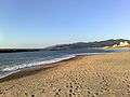 Senami Beach
Festivals
Murakami Taisai, a traditional regional festival, has been held in the downtown area on July 6 and 7, every year, since 1868.
External links
 Media related to Murakami, Niigata at Wikimedia Commons
- Official website (Japanese)
- Niigata Prefecture Official Travel Guide (multilingual)