Seirō, Niigata
| Seirō 聖籠町 | |||
|---|---|---|---|
| Town | |||
|
Seirō town hall | |||
| |||
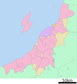 Location of Seirō in Niigata | |||
 Seirō
| |||
| Coordinates: 37°58′28.3″N 139°16′27.3″E / 37.974528°N 139.274250°ECoordinates: 37°58′28.3″N 139°16′27.3″E / 37.974528°N 139.274250°E | |||
| Country | Japan | ||
| Region | Chūbu (Kōshin'etsu) (Hokuriku) | ||
| Prefecture | NIigata | ||
| District | Kitakanbara | ||
| Area | |||
| • Total | 37.58 km2 (14.51 sq mi) | ||
| Population (June 2016) | |||
| • Total | 13,998 | ||
| • Density | 372/km2 (960/sq mi) | ||
| Time zone | Japan Standard Time (UTC+9) | ||
| Symbols | |||
| • Tree | Japanese black pine | ||
| • Flower | Rosa rugosa | ||
| Phone number | 0254-27-2111 | ||
| Address | 1635-4 Suwayama, Seirō-machi, Kitakanbara-gun, Niigata-ken 957-0192 | ||
| Website |
www | ||


Seirō (聖籠町 Seirō-machi) is a town located in Kitakanbara District, Niigata Prefecture, in the Hokuriku region of Japan. As of 1 June 2016, the town had an estimated population of 13,998 and a population density of 372 persons per km². Its total area was 37.58 square kilometres (14.51 sq mi).
Geography
Seirō is located in central Niigata Prefecture, sandwiched between the cities of Niigata and Shibata, with a small coastline on the Sea of Japan.
Surrounding municipalities
History
The area of present-day Seirō was part of ancient Echigo Province. The modern village of Seirō was established on April 1, 1889 with the creation of the municipalities system. It was raised to town status in August 1977.
Economy
The local economy is dominated by industry, notably the production of precision components and food processing. The Port of Niigata is a major employer.
Education
Seirō has three public elementary schools and one public middle school. The town does not have a high school.
Transportation
Railway
- Seirō is not served by an passenger train routes.
Highway
External links
 Media related to Seirō, Niigata at Wikimedia Commons
- Seirō official website (Japanese)