City of Tea Tree Gully
- This article is about the LGA in Adelaide. For the suburb of the same name, see Tea Tree Gully, South Australia.
| City of Tea Tree Gully South Australia | |||||||||||||
|---|---|---|---|---|---|---|---|---|---|---|---|---|---|
 | |||||||||||||
| Population | 98,861 (2015 est)[1] | ||||||||||||
| • Density | 1,038/km2 (2,690/sq mi) | ||||||||||||
| Established | 1858 | ||||||||||||
| Area | 95.21 km2 (36.8 sq mi) | ||||||||||||
| Mayor | Kevin Knight [2] | ||||||||||||
| Council seat | Modbury | ||||||||||||
| Region | Metropolitan Adelaide | ||||||||||||
| State electorate(s) | Little Para, Florey, Newland, Playford, Torrens, Wright | ||||||||||||
| Federal Division(s) | Mayo, Makin, Sturt | ||||||||||||
|
| |||||||||||||
| Website | City of Tea Tree Gully | ||||||||||||
| |||||||||||||
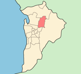
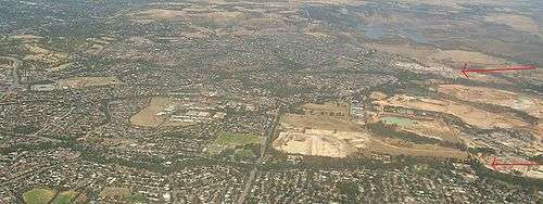
The City of Tea Tree Gully is in the Australian state of South Australia, in the outer north-eastern suburbs of Adelaide. The city has an estimated population of 98,861 people and is one of the most populous local government divisions in Adelaide. The major business district in the city is at Modbury, where Tea Tree Plaza, the Civic Centre and the library are located.
Howard, Lord Florey, Australian pathologist and co-discoverer of penicillin, was a resident of the City of Tea Tree Gully.
Suburbs and post codes
- Banksia Park - 5091
- Dernancourt - 5075
- Fairview Park - 5126
- Gilles Plains - 5086
- Golden Grove - 5125
- Gould Creek - 5114
- Greenwith - 5125
- Gulfview Heights - 5096
- Highbury - 5089
- Holden Hill - 5088
- Hope Valley - 5090
- Houghton - 5131
- Modbury - 5092
- Modbury Heights - 5092
- Modbury North - 5092
- Para Hills - 5096
- Redwood Park - 5097
- Ridgehaven - 5097
- St Agnes - 5097
- Salisbury East - 5109
- Salisbury Heights - 5109
- Surrey Downs - 5126
- Tea Tree Gully - 5091
- Upper Hermitage - 5131
- Valley View - 5093
- Vista - 5091
- Wynn Vale - 5127
- Yatala Vale - 5126
Council
The current council as of June 2016 is:
| Ward | Party[3] | Councillor | Notes | |
|---|---|---|---|---|
| Mayor | Independent | Kevin Knight | ||
| Balmoral | Labor | Justin Hanson | ||
| Independent | Stuart Headland | |||
| Drumminor | Liberal | Damian Wyld | ||
| Labor | Matthew Harbinson | |||
| Hillcott | Liberal | Paul Barbaro | ||
| Independent | Sandy Keane | |||
| Pedare | Independent | Bernie Keane | Deputy Mayor | |
| Liberal | Paula Luethen-Soper | |||
| Steventon | Labor | Jim McLafferty | ||
| Labor | Lucas Jones | |||
| Water Gully | Independent | Robin Coleman | ||
| Independent | Peter Field | |||
History
The Tea Tree gully itself passes through the Adelaide foothills roughly marking the easiest path eastwards from Grand Junction Road to Gumeracha. The 1850s settlement at the entrance to the gully (approximately where North East Road enters the foothills) was known as the village of 'Steventon' after a local resident, John Stevens, who was a major landowner in the area. The name Steventon is retained as one of the electoral wards of the City of Tea Tree Gully.
The council was originally proclaimed in October 1858 as the District Council of Tea Tree Gully, when the northern half of the District Council of Highercombe, which had been created in 1853, successfully seceded to form its own municipality. In the early 1930s, the two councils were considered unviable, being very small in relative size and population. The District Council of Highercombe was included in a Local Government Commission list of 53 local councils with annual revenue of less than £2000. Following the commission recommendation, the two councils were recombined under the name Tea Tree Gully in May 1935.[4]
It inherited the former 1855 Highercombe council chambers, which had been built in Tea Tree Gully, and used that building until 1967. The Old Tea Tree Gully Council Chambers survive today and are listed on the South Australian Heritage Register, having been the first purpose-built district council chambers in South Australia.[5][6] In 1967 the Tea Tree Gully civic centre was opened, comprising a new council chamber and civic hall. The municipality was granted city status and proclaimed as the City of Tree Gully in 1968.[7]
From 1954 to 1971 the population of Tea Tree Gully council rose from just over 2,500 to almost 37,000, and in 1975 it had reached approximately 55,000 as urban residential development quickly expanded.[8] By 2004 the population had exceeded 100,000.[7]
Chairmen and mayors of Tea Tree Gully
- William Henry Ind (1936-1943) [9]
- Albert George Dearman (1943-1951) [9]
- George Norman Lambert (1951-1954) [9]
- Albert George Dearman (1954-1955) [9]
- David Stanley Goodes (1955-1957) [9]
- Basil David Mitchell (1957-1960) [9]
- Viggo Ole Jacobsen (1960-1965) [9]
- William Green (1967-1969) [9]
- William Gilbert Brassington (1969-1972) [9]
- John Charles Burford (1972-1974) [9]
- John Garfield Tilley (1974-1981) [9]
- Donald David Stuart (1981-1982) [9]
- John Garfield Tilley (1982-1989) [9][10]
Geography
The gully to which the city name refers actually exists and is known to be sizable as it provided a gradient negotiable only by bullock wagons travelling through the Mt. Lofty Ranges. Additionally the gully had permanent freshwater springs which promoted the growth of tea trees in the area - thus the eventual name 'Tea Tree Gully'.
The 350-hectare (860-acre) Anstey Hill Recreation Park is adjacent to the suburbs of Vista and Tea Tree Gully.
Sister cities
The City of Tea Tree Gully, has one sister city.[11] it is the:
See also
Notes and references
- Notes
- ↑ "3218.0 – Regional Population Growth, Australia, 2014–15". Australian Bureau of Statistics. Retrieved 29 September 2016.
- ↑ "Elected Members". City of Tea Tree Gully. Retrieved 4 November 2016.
- ↑ "Council Members Register of Interests" (PDF). City of Tea Tree Gully. Retrieved 6 June 2016.
- ↑ Marsden, Susan (2012). "LOCAL GOVERNMENT ASSOCIATION OF SOUTH AUSTRALIA: A HISTORY OF SOUTH AUSTRALIAN COUNCILS to 1936" (PDF).
DC of Highercombe was the original local government area, established on 14 July 1853. The DC of Tea Tree Gully was detached on 7 October 1858, and Highercombe was absorbed into DC of Tea Tree Gully on 21 March 1935, returning the council to the 1853 boundaries.
- ↑ "The First Council Chambers". Tea Tree Gully Historical Society. Retrieved 30 March 2016.
- ↑ "Former Highercombe (subsequently Tea Tree Gully) Council Chambers". South Australian Heritage Register. Department of Environment, Water and Natural Resources. Retrieved 30 March 2016.
- 1 2 "A Short History of Tea Tree Gully". Tea Tree Gully Historical Society. Retrieved 30 March 2016.
- ↑ Auhl, 1976
- 1 2 3 4 5 6 7 8 9 10 11 12 13 Matthews, Penny (1986), South Australia, the civic record, 1836-1986, Wakefield Press, p. 585, ISBN 978-0-949268-82-2
- ↑ "Modbury High School Student Award". Rotary Club of Modbury. Retrieved 21 November 2016.
- ↑ "Sister City Information". City of Tea Tree Gully. Archived from the original on 29 August 2007. Retrieved 2008-01-02.
- Reference
- Auhl, Ian (1976). From settlement to city: a history of the district of Tea Tree Gully, 1836-1976. Blackwood, SA: Lynton Publications.
- Auhl, Ian (1993). Tea Tree Gully Historical Society, ed. From settlement to city: a history of the district of Tea Tree Gully, 1836-1976, 1976-1993. Modbury, SA: Tea Tree Gully Council. ISBN 9781742224770.
External links
- Official website
- City of Tea Tree Gully Library
- Gallery 1855
- City of Tea Tree Gully community profile (I.D. Consulting Pty Ltd)
- Council boundaries at June 2004 (City of Tea Tree Gully)
Coordinates: 34°50′S 138°41′E / 34.833°S 138.683°E