Crestview, Florida
| Crestview, Florida | |
|---|---|
| City | |
| City of Crestview | |
|
The Okaloosa County courthouse in March 2008 | |
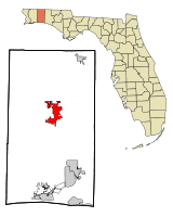 Location in Okaloosa County and the state of Florida | |
| Coordinates: 30°45′15″N 86°34′22″W / 30.75417°N 86.57278°WCoordinates: 30°45′15″N 86°34′22″W / 30.75417°N 86.57278°W | |
| Country |
|
| State |
|
| County |
|
| Area | |
| • Total | 12.8 sq mi (33.2 km2) |
| • Land | 12.8 sq mi (33.1 km2) |
| • Water | 0 sq mi (0.1 km2) |
| Elevation | 236 ft (72 m) |
| Population (2010) | |
| • Total | 20,978 |
| • Density | 1,483/sq mi (573/km2) |
| Time zone | Central (CST) (UTC-6) |
| • Summer (DST) | CDT (UTC-5) |
| ZIP codes | 32536, 32539 |
| Area code(s) | 850 |
| FIPS code | 12-15475[1] |
| GNIS feature ID | 0281044[2] |
| Website | http://www.cityofcrestview.org/ |

Crestview is a city in Okaloosa County, Florida, United States. The population was 20,978 at the 2010 census. It is the county seat of Okaloosa County.[3]
With an elevation of 235 feet (72 m) above sea level, it is one of the highest points in the state; it receives 65 inches (1,700 mm) of rainfall annually, the second-most of any city in the state of Florida, next to Fort Walton Beach with 69 inches. The town was once known as "the icebox of Florida", due to it having the coldest winters in the state. Today it goes by a more popular nickname as the "Hub City" of Northwest Florida.
Crestview is one of Florida's fastest growing cities, with residential developments, shopping, and land area to grow. It has, as of July 2007, become the largest city in Okaloosa County.[4] In 2007, George Whitehurst, who had been mayor for nearly 20 years, resigned, leading to the election of David Cadle. Cadle had recently retired as the long-time director of the Crestview High School band, The Big Red Machine.[5]
As part of the 2005 Base Realignment and Closure round, Crestview experienced further population growth as the U.S. Army's 7th Special Forces Group relocated from Fort Bragg, North Carolina to a newly built cantonment facility on the northern end of the Eglin Air Force Base reservation, approximately six miles south of the city.
Crestview is a principal city of the Fort Walton Beach-Crestview-Destin Metropolitan Statistical Area.
Etymology
Crestview’s name was chosen because of its location on the peak of a long woodland range between the Yellow and Shoal rivers which flow almost parallel on the east and west side of the city.
History
Crestview was largely an outgrowth of the coming of railroad service to the west Panhandle of Florida.[6] The Pensacola and Atlantic Railroad Company, chartered in 1881, opened its line between Pensacola and Apalachicola in January 1883. Soon two express passenger trains, the Atlantic Express and the Gulf Express, and a local accommodation train that stopped everywhere, were in daily operation. The expresses took about six hours to make the run, the local, thirteen hours. When the railroad company was unable to cover the interest owed bondholders, the Louisville and Nashville Railroad covered the shortfalls until 1885, and then foreclosed, merging the route into their system as the L & N's Pensacola and Atlantic Division.[7]
In 1894, sawmill operator W. B. Wright opened the 26-mile (42 km) Yellow River Railroad between Crestview and Florala, Alabama via Auburn, Campton, and Laurel Hill. The L & N supplied the line with freight cars, and in 1906, purchased the operation,[8] as the Yellow River Branch. This line, without any major shippers on it to make it profitable, was used for freight car storage for a time in the early 1980s and then was abandoned with 25.3 miles of the route lifted after May 1985,[9] although the right of way still exists, with some portions paved as local streets.
The 1920 Census figures for the City of Crestview, precinct 15 was 938.[10] On July 23,1920, Crestview hosted the first public hanging for Okaloosa County. Robert Blackwell was convicted of killing Nancy and Bud Davis in 1917, and received the death penalty. One week prior to the date of his hanging, Blackwell confessed, and his confession was printed in area newspapers on his hanging day.[11] The second and last Okaloosa County hangings took place in Crestview, Florida on September 23,1921. Thousands of curious onlookers came from surrounding states. Putnam Ponsell and Jacob Benjamin Marin were publicly hanged for killing John F. Tuggle. This double hanging in 1921 was the last public hanging in Florida. [12]
Smith-Johnson Company, Inc. opened a garment factory in Crestview in 1937 that utilized 250 machines and employed "around 300 persons."[13]
A modern bus terminal served by the Greyhound Lines' Jacksonville-Los Angeles route, as well as connections north to Atlanta, Memphis and New York,[14] featuring waiting rooms, lounge, smoking rooms, restaurant, and loading concourse, opened on the corner of Ferdon and Pearl Streets on Friday 9 May 1941. As per the standards of the era, it was segregated.[15]
As nearby Eglin Field was expanded into a major testing base, the Louisville and Nashville Railroad laid a long sidetrack in Crestview in the spring of 1941 to handle the number of oil tankcars required to supply the Asphault Products Company with material for the vast paving job of the ten new airfields. A fleet of trucks were operated round the clock to offload an estimated 180 car loads of petroleum product for the task.[16]
A recreation center for enlisted men at the expanding Eglin Field was opened in Crestview on Saturday 21 June 1941, through the efforts of the Community Recreation Council, the Works Progress Administration, and the Okaloosa Progressive Association.[17][18]
In late January 1943, a "misunderstanding" by the constabulary of Crestview put the community off limits to military personnel from Eglin Field. The Pensacola News Journal reported on 31 January that the town was off the "black list." According to the front page report, "The out-of-town bounds restrictions that had been imposed on Crestview by Eglin field [sic] authorities were lifted at noon today [30 January], after a conference of town officials and Eglin authorities, and it was stated that soldiers from the field may visit the town. Billy Powell, town marshal, whose arrest of a soldier for reckless driving and an Eglin officer for interference, precipitated the trouble during the week, has been suspended by the town council. Powell was himself put in the county jail by an MP detachment from Eglin field and stayed there until his attorney, John M. Coe, Pensacola, released him through circuit court action."[19] The servicemen involved had taken a convoy of newly trained Aviation Engineering Battalion personnel to load on a train at Crestview when the over-zealous marshal tried to arrest a black jeep driver for a U-turn, thus leading to the unpleasantness. After Eglin Commanding Officer Brigadier General Grandison Gardner explained the economics of wartime to the city fathers, they chose a more reasonable replacement for town marshal.
On July 31, 1949, the L&N inaugurated the Gulf Wind streamliner through Crestview between New Orleans and Jacksonville, in conjunction with the Seaboard Air Line Railroad, replacing the heavyweight New Orleans-Florida Limited. It operated until April 30, 1971, when Amtrak took over most U.S. rail passenger service and discontinued this route.
In the 1960s, Crestview was the location for the studio of the Apache Records label.[20]
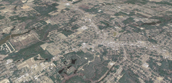
Geography
Topography
Crestview is located at 30°45′15″N 86°34′22″W / 30.754211°N 86.572650°W (30.754211, -86.572650).[21]
According to the United States Census Bureau, the city has a total area of 12.8 square miles (33 km2), of which 12.8 square miles (33 km2) is land and 0.04 square miles (0.10 km2) (0.23%) is water.
Climate
Crestview's climate is officially described as humid subtropical (Köppen Cfa). In summer, Crestview has some of the hottest temperatures in the state, with an average summer high of 92 °F (33 °C). Lows in summer average in the high 60s to low 70s, with each year seeing a handful of 100 °F+ days. The all-time record high is 105 °F (41 °C), recorded on July 14, 1980.[22]
Winters compare to those of interior Alabama, Mississippi, and Georgia. Highs average in the lower to mid 60s (16°-19 °C), and lows average upper 30s (almost 4 °C). The all-time record low is −1 °F (−18 °C), on February 13, 1899. The city lies within the USDA Hardiness Zone 8,[23] the coldest temperature of the season is typically between 10 °F (−12 °C) and 20 °F (−7 °C); averages 39.8 nights where the temperature falls below freezing, with the average window for freezes being November 9 through March 28.[22] Snowfall occurs every three years on average, however, significant amounts only happen once every 10 years. On Christmas Eve of 1989, Crestview received over 3 inches (76 mm) of snow.
Vegetation here consists of typical Floridian vegetation as well as several deciduous species from further north. Some palm trees are found here, although only cold-hardy varieties like the state tree, the Sabal palmetto, as well as types of dogwood, maple, hickory, and sweet gum. Blueberries are a native crop raised for sale locally, in addition to Strawberries. In 1919, M.A. Sapp reported shipping his blueberries from May 10 until the end of August, netting $605.85 for his crop, in addition to that which he shared with friends and family. [24] Fall foliage can be seen in November and December, and Spring blossoms occur from early March through May. Summer typically lasts from late April to early October, and winter lasts from mid-December through mid-February.
| Climate data for Crestview, Florida (Bob Sikes Airport), 1981–2010 normals, extremes 1948-present | |||||||||||||
|---|---|---|---|---|---|---|---|---|---|---|---|---|---|
| Month | Jan | Feb | Mar | Apr | May | Jun | Jul | Aug | Sep | Oct | Nov | Dec | Year |
| Record high °F (°C) | 85 (29) |
83 (28) |
90 (32) |
95 (35) |
101 (38) |
104 (40) |
105 (41) |
103 (39) |
100 (38) |
94 (34) |
87 (31) |
83 (28) |
105 (41) |
| Average high °F (°C) | 61.7 (16.5) |
65.5 (18.6) |
72.0 (22.2) |
78.3 (25.7) |
85.7 (29.8) |
90.3 (32.4) |
91.7 (33.2) |
91.3 (32.9) |
87.6 (30.9) |
80.0 (26.7) |
71.6 (22) |
63.4 (17.4) |
78.3 (25.7) |
| Average low °F (°C) | 36.5 (2.5) |
39.4 (4.1) |
44.7 (7.1) |
50.7 (10.4) |
59.0 (15) |
66.8 (19.3) |
69.7 (20.9) |
69.6 (20.9) |
64.8 (18.2) |
53.9 (12.2) |
44.4 (6.9) |
38.8 (3.8) |
53.2 (11.8) |
| Record low °F (°C) | 8 (−13) |
10 (−12) |
17 (−8) |
29 (−2) |
38 (3) |
52 (11) |
57 (14) |
56 (13) |
40 (4) |
28 (−2) |
17 (−8) |
9 (−13) |
8 (−13) |
| Average precipitation inches (mm) | 5.77 (146.6) |
5.10 (129.5) |
6.32 (160.5) |
4.16 (105.7) |
4.44 (112.8) |
6.61 (167.9) |
7.18 (182.4) |
6.05 (153.7) |
4.44 (112.8) |
3.90 (99.1) |
4.64 (117.9) |
4.30 (109.2) |
62.91 (1,598.1) |
| Average precipitation days (≥ 0.01 in) | 10.1 | 9.2 | 9.3 | 7.6 | 8.6 | 12.6 | 15.9 | 13.7 | 9.6 | 7.7 | 8.0 | 9.8 | 122.1 |
| Source: NOAA,[22] The Weather Channel[25] | |||||||||||||
Demographics
| Historical population | |||
|---|---|---|---|
| Census | Pop. | %± | |
| 1920 | 500 | — | |
| 1930 | 930 | 86.0% | |
| 1940 | 2,252 | 142.2% | |
| 1950 | 5,003 | 122.2% | |
| 1960 | 7,467 | 49.3% | |
| 1970 | 7,952 | 6.5% | |
| 1980 | 7,617 | −4.2% | |
| 1990 | 9,886 | 29.8% | |
| 2000 | 14,766 | 49.4% | |
| 2010 | 20,978 | 42.1% | |
| Est. 2015 | 23,270 | [26] | 10.9% |
As of the census[1] of 2000, there were 14,766 people, 5,297 households, and 3,893 families residing in the city. The population density was 1,153.7 people per square mile (445.4/km2). There were 5,918 housing units at an average density of 462.4 per square mile (178.5/km2). The racial makeup of the city was 74.71% White, 18.41% African American, 0.60% Native American, 2.28% Asian, 0.15% Pacific Islander, 1.22% from other races, and 2.62% from two or more races. Hispanic or Latino of any race were 3.26% of the population. The population estimate for 2005 was 17,707 people.
There were 5,297 households out of which 40.9% had children under the age of 18 living with them, 53.5% were married couples living together, 16.2% had a female householder with no husband present, and 26.5% were non-families. 22.7% of all households were made up of individuals and 8.3% had someone living alone who was 65 years of age or older. The average household size was 2.65 and the average family size was 3.09.
In the city the population was spread out with 29.2% under the age of 18, 8.9% from 18 to 24, 32.5% from 25 to 44, 17.8% from 45 to 64, and 11.5% who were 65 years of age or older. The median age was 33 years. For every 100 females there were 93.4 males. For every 100 females age 18 and over, there were 91.5 males.
The median income for a household in the city was $23,122, and the median income for a family was $31,824. Males had a median income of $27,829 versus $19,261 for females. The per capita income for the city was $14,479. About 45.2% of families and 59.7% of the population were below the poverty line, including 56.2% of those under age 18 and 30.4% of those age 65 or over.
Transportation
Bob Sikes Airport is a public-use airport located 3 miles (4.8 km) northeast of the central business district. It was established in 1941 as the CAA Airport.
Major highways through Crestview are U.S Route 90 heading east-west and State Road 85 heading north-south, intersecting each other north of I-10, which also runs through Crestview.
From early 1993 through August 2005 Crestview was served by the tri-weekly Amtrak Sunset Limited, but service east of New Orleans to Jacksonville and Orlando was suspended due to damage to the rail line of CSX during Hurricane Katrina in 2005. Attempts are being made to have service restored. This was previously the route of the Gulf Wind operated by the Louisville and Nashville Railroad.
Nicknames
The town was once known as "the icebox of Florida", due to it having the coldest winters in the state. Crestview is now known as the "Hub City", because of the convergence of Interstate 10, State Road 85, U.S. Highway 90, the CSX railroad, and the Yellow River and Shoal River in or near the city.
Sister city
References
- 1 2 "American FactFinder". United States Census Bureau. Archived from the original on 2013-09-11. Retrieved 2008-01-31.
- ↑ "US Board on Geographic Names". United States Geological Survey. 2007-10-25. Retrieved 2008-01-31.
- ↑ "Find a County". National Association of Counties. Archived from the original on 2011-05-31. Retrieved 2011-06-07.
- ↑ http://www.factfinder.census.gov
- ↑ http://www.crestviewband.com/
- ↑ Turner, Gregg M., "A Journey Into Florida Railroad History", University Press of Florida, Gainesville, 2008, Library of Congress card number 2007050375, ISBN 978-0-8130-3233-7, page 109.
- ↑ Turner, Gregg M., "A Journey Into Florida Railroad History", University Press of Florida, Gainesville, 2008, Library of Congress card number 2007050375, ISBN 978-0-8130-3233-7, page 110.
- ↑ Turner, Gregg M., "A Journey Into Florida Railroad History", University Press of Florida, Gainesville, 2008, Library of Congress card number 2007050375, ISBN 978-0-8130-3233-7, page 166-167.
- ↑ http://www.dot.state.fl.us/rail/PlanDevel/RSAC/Mtg2files/Premtg/1985%20Inventory.pdf
- ↑ Crestview, the Forkland, Betty Sanders Curenton, Claudia Garrett Patten, ISBN 0-9725265-0-1
- ↑ The Okaloosa News Journal, July 23,1920
- ↑ The Okaloosa News-Journal, September 23, 1921
- ↑ Crestview, Florida, "Work To Pick Up In Factory!" Okaloosa News-Journal, Monday 15 April 1940, Volume 26, Number 16 - Extra, pages 1-2.
- ↑ Display advert, The Okaloosa News-Journal, Friday 9 May 1941, Volume 27, Number 18, page 4, Section 2.
- ↑ Crestview, Florida, "New Bus Station Now Open", The Okaloosa News-Journal, Friday 9 May 1941, Volume 27, Number 18, page 1.
- ↑ Crestview, Florida, "Crews Work 24 Hours A Day To Haul Asphault", Okaloosa News-Journal, 23 May 1941, Vol. 27, No. 20, p. 1.
- ↑ Crestview, Florida, "Recreation Center Is Now Assured For Men Of Eglin Field: To Be Opened With Ceremonies Saturday, June 21st", Okaloosa News-Journal, Friday 13 June 1941, Volume 27, Number 23, page 1.
- ↑ Crestview, Florida, "Crestview Highly Commended For Opening Recreation Center For Eglin Enlisted Men - Crestview People Did Not Shirk Duty When Need Explained", Okaloosa News-Journal, Friday 31 October 1941, Volume 27, Number 42, page 4.
- ↑ Special, "Crestview Is Off Eglin's 'Black List'", Pensacola News Journal, Pensacola, Florida, 31 January 1943, p. 1.
- ↑ Crestview, Florida, "Local Recording Company Issues First Discs Here", The Okaloosa News-Journal, Thursday 3 March 1960, Volume 46, Number 9, page A-5.
- ↑ "US Gazetteer files: 2010, 2000, and 1990". United States Census Bureau. 2011-02-12. Retrieved 2011-04-23.
- 1 2 3 "NOWData - NOAA Online Weather Data". National Oceanic and Atmospheric Administration. Retrieved 2016-02-08.
- ↑ "What is my arborday.org Hardiness Zone? - Crestview, FL". Arbor Day Foundation. Retrieved 2013-12-09.
- ↑ The Punta Gorda Herald, Vol XXXII, Number 43, Thursday, October 23,1919
- ↑ "Average Weather for Crestview, FL". The Weather Channel. 2009. Retrieved 2009-01-26.
- ↑ "Annual Estimates of the Resident Population for Incorporated Places: April 1, 2010 to July 1, 2015". Retrieved July 2, 2016.
- ↑ "Census of Population and Housing". Census.gov. Archived from the original on May 11, 2015. Retrieved June 4, 2015.
External links
- Official website
- Crestview Area Chamber of Commerce
- Northwest Florida Daily News
- American Legion Post 75
- North Okaloosa Amateur Radio Club (NOARC)
- Crestview Community Television (CCTV)
- Crestview News-Bulletin
Municipalities and communities of Okaloosa County, Florida, United States | ||
|---|---|---|
| Cities |  | |
| Towns | ||
| CDPs | ||
| Unincorporated communities | ||