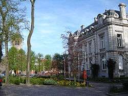
Destelbergen
| Destelbergen | |||
|---|---|---|---|
| Municipality | |||
 | |||
| |||
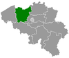
 Destelbergen Location in Belgium | |||
|
Location of Destelbergen in East Flanders 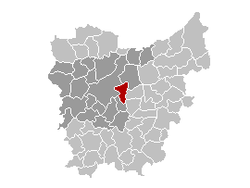 | |||
| Coordinates: 51°3′N 3°48′E / 51.050°N 3.800°ECoordinates: 51°3′N 3°48′E / 51.050°N 3.800°E | |||
| Country | Belgium | ||
| Community | Flemish Community | ||
| Region | Flemish Region | ||
| Province | East Flanders | ||
| Arrondissement | Ghent | ||
| Government | |||
| • Mayor | Marc De Pauw (VLD) | ||
| • Governing party/ies | VLD, CD&V | ||
| Area | |||
| • Total | 26.56 km2 (10.25 sq mi) | ||
| Population (1 January 2016)[1] | |||
| • Total | 17,867 | ||
| • Density | 670/km2 (1,700/sq mi) | ||
| Postal codes | 9070 | ||
| Area codes | 09 | ||
| Website | www.destelbergen.be | ||

Destelbergen (Dutch pronunciation: [ˌdɛstəlˈbɛrɣə(n)]) is a municipality located in the Belgian province of East Flanders. The municipality comprises the towns of Destelbergen proper and Heusden and was created on January 1, 1977, by the fusion of these two municipalities. Its western border touches the municipality of Ghent and Melle and is formed by an ancient silted up branch of the river Scheldt.
On January 1, 2011, Destelbergen had a total population of 17,636. The total area is 26.56 km² which gives a population density of 664 inhabitants per km².
Attractions worth seeing are the many residential castles, a Gaulish farmhouse, and the Damvallei nature reserve.
References
- ↑ Population per municipality as of 1 January 2016 (XLS; 397 KB)
External links
 Media related to Destelbergen at Wikimedia Commons
- Official website (Dutch)
 |
Lochristi | | ||
| Ghent | |
Laarne | ||
| ||||
| | ||||
| Melle | Wetteren |
This article is issued from Wikipedia - version of the 12/1/2016. The text is available under the Creative Commons Attribution/Share Alike but additional terms may apply for the media files.