Zottegem
| Zottegem | |||
|---|---|---|---|
| Municipality | |||
 | |||
| |||
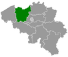
 Zottegem Location in Belgium | |||
|
Location of Zottegem in East Flanders  | |||
| Coordinates: 50°52′N 03°48′E / 50.867°N 3.800°ECoordinates: 50°52′N 03°48′E / 50.867°N 3.800°E | |||
| Country | Belgium | ||
| Community | Flemish Community | ||
| Region | Flemish Region | ||
| Province | East Flanders | ||
| Arrondissement | Aalst | ||
| Government | |||
| • Mayor | Jenne De Potter (CD&V) | ||
| • Governing party/ies | CD&V, sp.a | ||
| Area | |||
| • Total | 56.66 km2 (21.88 sq mi) | ||
| Population (1 January 2016)[1] | |||
| • Total | 25,899 | ||
| • Density | 460/km2 (1,200/sq mi) | ||
| Postal codes | 9620 | ||
| Area codes | 09 | ||
| Website | www.zottegem.be | ||

Zottegem (Dutch pronunciation: [ˈzɔtəɣɛm]) is a municipality located in Belgium and more particularly in Flanders, in the province of East Flanders. The municipality comprises the town of Zottegem proper and the villages of Elene, Erwetegem, Godveerdegem, Grotenberge, Leeuwergem, Oombergen, Sint-Goriks-Oudenhove, Sint-Maria-Oudenhove, Strijpen and Velzeke-Ruddershove. On January 1, 2006, Zottegem had a total population of 24,548. The total area is 56.66 km² which gives a population density of 433 inhabitants per km².
Zottegem is crossed by two brooks, the Molenbeek in Grotenberge and Leeuwergem, as well as the Molenbeek-Ter Erpenbeek in Godveerdegem, Erwetegem, and Grotenberge.
With its beautiful nature Zottegem is part of the geographical area Vlaamse Ardennen (Flemish Ardennes) and the Denderstreek. There is also a little village in Zottegem Bevegem that was never a municipality before.
Places of interest
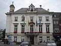
Town Hall 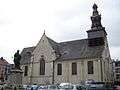
Church of the Assumption of Our Lady 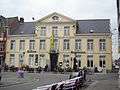
The former Deanery 
Egmont Castle 
Statue of Lamoral, Count of Egmont 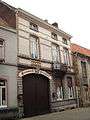
Crombé Brewery 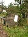
The "Duivelsvoetstap" (Devil's footprint)
Famous inhabitants
- Lamoral, Count of Egmont, general and statesman, is buried in Zottegem
- Patricia de Martelaere (b. in Zottegem), writer
- Magali Uytterhaegen (b. in Zottegem), actress (The curiosity of Chance)
References
- ↑ Population per municipality as of 1 January 2016 (XLS; 397 KB)
External links
 Media related to Zottegem at Wikimedia Commons
- Official website - Information available in Dutch and limited information available in English, French and German
 |
Gavere | Oosterzele | Sint-Lievens-Houtem | |
| Zwalm | |
Herzele | ||
| ||||
| | ||||
| Brakel | Lierde |