Duarte, California
| City of Duarte | ||
|---|---|---|
| City | ||
| ||
| Motto: "City of Health" | ||
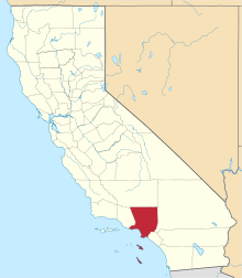
 Location of Duarte in Los Angeles County, California | ||
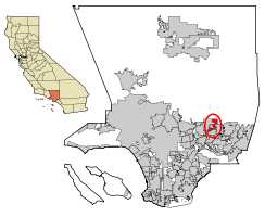
 City of Duarte Location in the United States | ||
| Coordinates: 34°8′25″N 117°57′42″W / 34.14028°N 117.96167°WCoordinates: 34°8′25″N 117°57′42″W / 34.14028°N 117.96167°W | ||
| Country |
| |
| State |
| |
| County |
| |
| Incorporated | August 22, 1957[1] | |
| Government | ||
| • Type | Council-Manager | |
| • Mayor | Sam Kang[2] | |
| • Mayor Pro Tem | Margaret Finlay[2] | |
| • City council[2] |
John Fasana Tzeitel Paras-Caracci Liz Reilly | |
| • City manager | Darrell George | |
| • City attorney | Jeff Melching (Rutan & Tucker) | |
| Area[3] | ||
| • Total | 6.690 sq mi (17.328 km2) | |
| • Land | 6.690 sq mi (17.328 km2) | |
| • Water | 0 sq mi (0 km2) 0% | |
| Elevation | 512 ft (156 m) | |
| Population (April 1, 2010)[4] | ||
| • Total | 21,321 | |
| • Estimate (2013)[4] | 21,724 | |
| • Density | 3,200/sq mi (1,200/km2) | |
| Time zone | Pacific (UTC-8) | |
| • Summer (DST) | PDT (UTC-7) | |
| ZIP codes | 91009-91010 | |
| Area code | 626 | |
| FIPS code | 06-19990 | |
| GNIS feature ID | 1652699 | |
| Website |
www | |
Duarte (/ˈdwɑːrtiː/ or /duːˈɑːrteɪ/; from Spanish or Portuguese [ˈdwaɾte]) is a city in Los Angeles County, California, United States. As of the 2010 census, the city population was 21,321, down from 21,486 at the 2000 census.
It is bounded to the north by the San Gabriel Mountains, to the north and west by the cities of Bradbury and Monrovia, to the south by the city of Irwindale, and to the east by the cities of Irwindale and Azusa.
Duarte is located on historic U.S. Route 66 which today follows Huntington Drive through the middle of the city. The town holds an annual Salute to Route 66 Parade on the third weekend in September on Huntington Drive.
Geography
Duarte is located at 34°08′25″N 117°57′42″W / 34.140416°N 117.961678°W.[5]
According to the United States Census Bureau, the city has a total area of 6.7 square miles (17 km2), all land.
Demographics
| Historical population | |||
|---|---|---|---|
| Census | Pop. | %± | |
| 1960 | 13,962 | — | |
| 1970 | 14,981 | 7.3% | |
| 1980 | 16,766 | 11.9% | |
| 1990 | 20,688 | 23.4% | |
| 2000 | 21,486 | 3.9% | |
| 2010 | 21,321 | −0.8% | |
| Est. 2015 | 21,990 | [6] | 3.1% |
2010
The 2010 United States Census[8] reported that Duarte had a population of 21,321. The population density was 3,186.8 people per square mile (1,230.4/km²). The racial makeup of Duarte was 11,076 (51.9%) White (26.9% Non-Hispanic White),[9] 1,587 (7.4%) African American, 179 (0.8%) Native American, 3,361 (15.8%) Asian, 26 (0.1%) Pacific Islander, 4,108 (19.3%) from other races, and 984 (4.6%) from two or more races. Hispanic or Latino of any race were 10,190 persons (47.8%).
The Census reported that 20,914 people (98.1% of the population) lived in households, 19 (0.1%) lived in non-institutionalized group quarters, and 388 (1.8%) were institutionalized.
There were 7,013 households, out of which 2,458 (35.0%) had children under the age of 18 living in them, 3,597 (51.3%) were opposite-sex married couples living together, 1,004 (14.3%) had a female householder with no husband present, 363 (5.2%) had a male householder with no wife present. There were 285 (4.1%) unmarried opposite-sex partnerships, and 66 (0.9%) same-sex married couples or partnerships. 1,666 households (23.8%) were made up of individuals and 888 (12.7%) had someone living alone who was 65 years of age or older. The average household size was 2.98. There were 4,964 families (70.8% of all households); the average family size was 3.54.
The population was spread out with 4,737 people (22.2%) under the age of 18, 1,863 people (8.7%) aged 18 to 24, 5,567 people (26.1%) aged 25 to 44, 5,776 people (27.1%) aged 45 to 64, and 3,378 people (15.8%) who were 65 years of age or older. The median age was 39.9 years. For every 100 females there were 89.6 males. For every 100 females age 18 and over, there were 85.8 males.
There were 7,254 housing units at an average density of 1,084.3 per square mile (418.6/km²), of which 4,703 (67.1%) were owner-occupied, and 2,310 (32.9%) were occupied by renters. The homeowner vacancy rate was 1.1%; the rental vacancy rate was 4.4%. 14,796 people (69.4% of the population) lived in owner-occupied housing units and 6,118 people (28.7%) lived in rental housing units.
According to the 2010 United States Census, Duarte had a median household income of $62,250, with 13.4% of the population living below the federal poverty line.[9]
2000
As of the census[10] of 2000, there are 21,486 people, 6,635 households, and 4,889 families residing in the city. The population density is 3,215.7 inhabitants per square mile (1,241.9/km²). There are 6,805 housing units at an average density of 1,018.5 per square mile (393.3/km²). The racial makeup of the city is 52.02% White, 9.08% Black or African American, 0.94% Native American, 12.62% Asian, 0.11% Pacific Islander, 19.99% from other races, and 5.23% from two or more races, while 43.41% of the population are Hispanic or Latino of any race.
There are 6,635 households out of which 38.9% have children under the age of 18 living with them, 54.8% are married couples living together, 13.6% have a female householder with no husband present, and 26.3% are non-families. 21.5% of all households are made up of individuals and 9.4% have someone living alone who is 65 years of age or older. The average household size is 3.16 and the average family size is 3.70.
In the city the population is spread out with 28.2% under the age of 18, 8.5% from 18 to 24, 29.6% from 25 to 44, 21.8% from 45 to 64, and 11.9% who are 65 years of age or older. The median age is 34 years. For every 100 females there are 90.9 males. For every 100 females age 18 and over, there are 85.8 males.
The median income for a household in the city is $50,744, and the median income for a family is $56,556. Males have a median income of $39,812 versus $33,045 for females. The per capita income for the city is $19,648. 11.3% of the population and 8.4% of families are below the poverty line. Out of the total population, 13.3% of those under the age of 18 and 10.6% of those 65 and older are living below the poverty line.
A September 27, 2010 article in Forbes magazine described Duarte's 91008 zip code as the most expensive housing market in the country.[11](even though that ZIP code actually belonged to the neighboring city of Bradbury, Forbes refused to admit the error)
Government and infrastructure
In the United States House of Representatives, Duarte is in California's 32nd congressional district, represented by Democrat Grace Napolitano.[12]
Duarte has a council-manager government with a city council whose five members are directly elected by residents. The current mayor is Sam Kang.[2]
The Los Angeles County Department of Health Services operates the Monrovia Health Center in Monrovia, serving Duarte.[13]
Background/history
Around 500 B.C., a band of Shoshonean-speaking Indians established settlements in what is now the San Gabriel Valley. These Native Americans came to be called the Gabrieliño Indians (after San Gabriel, the local mission) by early Spanish explorers, but now prefer to be called the Tongva. The Tongva did not practice agriculture, but instead relied upon the wild seeds, berries, and plants that grew near the rivers and marshlands. Since the San Gabriel Valley area was home to large numbers of oak trees such as coast live oak and interior live oak, a staple of the Tongva diet was an acorn mush made by boiling acorn flour.
Duarte's history with Europeans dates back to 1769, when all land in California was claimed by the king of Spain. The first Europeans visited the San Gabriel Valley, including Duarte, during a 1769 expedition from San Diego to Monterey Bay commanded by Don Gaspar de Portolà. Accompanying Portolà was a Franciscan priest from Junípero Serra's order in Mexico, Juan Crespí, who served as the diarist of the expedition. Much of what is known of early California is known only from the detailed descriptions recorded by Crespi.
On September 8, 1771, the Franciscans established the Mission San Gabriel Arcangel in the San Gabriel Valley.[14] The mission was a resting point for early California travelers and gathered most of the native Tongva into an agricultural lifestyle. Following Mexican independence in 1821, the mission lands were nationalized.
On May 10, 1841, the governor of Alta California, Juan Bautista Alvarado, granted to former Mexican corporal Andrés Duarte and his wife nearly 7,000 acres (28 km2) of prime land in the central-northern San Gabriel Valley. Duarte named his new holdings "Rancho Azusa de Duarte". The name Azusa was derived from Asuksa-gna, the name of the Tongva settlement on the Foothills of California, on the western side of the alluvial fan where the San Gabriel River exits the San Gabriel Mountains; a portion of this area forms the northeastern-most corner of Duarte. That land grant now comprises portions of Arcadia, portions of Monrovia, all of Bradbury, all of Duarte, portions of Irwindale, portions of Azusa and a portion of Baldwin Park. Corporal Duarte had the local Indians build a small hut for his family and help him plant a kitchen garden and orchards near "the Indian Springs of the Asuksas" in Fish Canyon.
Alta California was given to the United States in 1848 following the end of the Mexican–American War. In 1851, Congress passed a bill that established a Board of Land Commissioners whose duty was to determine the validity of all grants of Alta California land by Spanish and Mexican authorities.
Corporal Duarte began incurring legal expenses and other debts, which he defrayed by selling portions of his Rancho. This first sale was a 225-acre (0.91 km2) parcel at the southern end of the Rancho to Michael Whistler and two unidentified colleagues. Whistler later bought out his colleagues and sold the entire parcel to Dr. Nehemiah Beardslee, who started the first school in Duarte (which now bears his surname) and laid out the first section of Duarte's water lines. Corporal Duarte divided much of the Rancho's remainder into 40-acre (16 ha) plots and sold them individually. Corporal Duarte finally won a favorable ruling from the Supreme Court for his land grant case in 1878, but by then he had sold the entire Rancho.
Many of Duarte's earliest pioneer families came to Duarte in the mid-19th century for their health, the pleasant climate, and the fertile soil. English settlers, Americans from the Midwest and Deep South, Latinos who remained from the Rancho and Japanese immigrants enabled Duarte to grow into a thriving agricultural community specializing in citrus production.
Two medical institutions were started in Duarte in the early part of the 20th century. In 1913, the Jewish Consumptive Relief Association started a tuberculosis sanitarium in the form of a small tent city on 40 acres (16 ha) of land south of Duarte Road. This later evolved into the world-renowned City of Hope National Medical Center, a recognized leader in fighting cancer and other catastrophic diseases. In 1930, a group of Carmelite nuns known as the Carmelite Sisters of the Most Sacred Heart of Los Angeles established the Santa Teresita Rest Home, known until recently as Santa Teresita Medical Center. After decades as a full-service hospital, Santa Teresita was downgraded to "medical center" in the early 21st century, after financial problems, caused both by administrative missteps as well as the costs of providing medical coverage to the uninsured, forced the hospital to close its emergency room. Santa Teresita now operates as an "outpatient services only" facility.
In 1957, a dedicated group of community members, fearing annexation by neighboring cities, led a fight for incorporation. Indeed, parts of the original Rancho had already been annexed by neighboring Monrovia, Azusa, Irwindale, and Baldwin Park. At the same time, a rival group representing an affluent enclave in the foothills started a competing drive for incorporation, and broke off to form the separate City of Bradbury. A 2001 Los Angeles Times article stated that their petition for incorporation arrived in Sacramento on August 22, 1957, "mere moments" before the petition that would have included them in the City of Duarte. Still, many ties between the two communities remain in that they both form the Duarte Unified School District; they both share the same post office and(until October 2008) a ZIP code(91010); and they both share combined public services such as the Los Angeles County Sheriff's Department and Los Angeles County Fire Department, and garbage pickup(provided by Burrtec Waste Services).
The original city logo was created by Bill Botts Sr. in 1957. It consisted of a double-circular seal, with the inner circle containing an adobe arch featuring the Rancho Azusa de Duarte "d" brand (inside the arch is the original date of the Rancho's establishment, 1841) while the outer circle features the year of Duarte's incorporation (1957). The current city logo was created in early 1982 to mark Duarte's 25th anniversary of cityhood.
Like many of its neighbors, modern Duarte is a bedroom community. The City of Duarte is geographically isolated from population centers to the east and south due to the San Gabriel River and rock quarry operations in Irwindale and Azusa. These factors have proven to be an ongoing economic challenge for local businesses as the city attracts little outside spending, and most residents spend their money elsewhere. Due to air quality and noise concerns, the City of Duarte has sought repeatedly to halt expansion of neighboring quarry operations, but has had no success against the monied interests behind the quarries and the neighboring city governments beholden to them. Still, over the past few decades, the city leadership has succeeded in bringing retail development to the western portion of Duarte beginning, notably, with the redevelopment of the Big Sky Drive-in Theater as a shopping plaza with a Gemco superstore (which is now a Target). Later, the city's obsolete municipal pool, known as Aqualand, and a well known Route-66 diner (known as the "Boulevard Cafe") were replaced with a Ralphs shopping center. In the early 21st century, Wal-Mart opened on the western edge of the city, as did a CarMax used-car superstore. In 2009, the city welcomed a new mini-shopping center, including a Best Buy, around the site of its Staples store. As of January 2010, a Sonic Drive-In opened in the Target Shopping Center. In March, 2010, the newest 99 Cents Only Store opened in the Big Lots center on Huntington. In 2016, a Smart & Final Extra store replaced the Ralphs supermarket, which had closed in 2015. And a Grocery Outlet replaced Mike's Foods, in a heavily remodeled section of the Duarte Shopping Center at Huntington and Buena Vista.
Education
The Duarte Unified School District serves students from Duarte, Bradbury, and unincorporated communities to the south of Duarte and Monrovia. The district contains five elementary schools (Maxwell, Andres Duarte, Beardslee, Royal Oaks, and Valley View), one middle school (Northview Intermediate School), one high school (Duarte High School) and one continuation high school (Mt. Olive High School, since renamed to the "Mt. Olive Institute of Technology" as of June 2013).
Within Duarte, there are also five licensed private schools. Foothill Oaks Academy is a non-sectarian school serving students from preschool through 8th grade. The Duarte Montessori School is affiliated with the American Montessori Society and serves students from preschool through 2nd grade. The School of the Little Scholar is a non-sectarian preschool. ABC School is another non-sectarian preschool that focuses on children with special education needs. The Hayden Child Care Center is a Roman Catholic-affiliated school serving students in preschool and kindergarten.
Places of worship
Christian
Baptist
- First Baptist Church of Duarte
- Grace Fellowship
- Berean Bible Baptist Church
- New Jerusalem Missionary Baptist Church
Church of Jesus Christ of Latter-day Saints
- Duarte 1st and 2nd ward
Evangelical
- Christian Alliance Bible Church (Chinese Evangelical)
- Covenant Life Ministries
Methodist
- Church of The Foothills: United Methodist Church of Duarte
Pentecostal
- New Life Assembly of God
- New Hope Church of God in Christ
Roman Catholic
- St. Joseph's Chapel of Santa Teresita Medical Center – offers Tridentine Mass as well as Novus Ordo Mass
- Carmelite Healthcare Apostolate convent – branch convent of Discalced Carmelites- not open to the public
Other non-denominational
- Duarte Christian Church
- Joy Christian Center
- Church of Christ (Independent)
Islamic
- Masjid Qurtubah
Public safety
The Los Angeles County Sheriff's Department (LASD) operates the Temple Station in Temple City, serving not only Duarte, but also neighboring Bradbury, while fire protection services are provided by the Los Angeles County Fire Department through Station 44 (paramedic services are provided by nearby Stations 29 in Baldwin Park and 32 in Azusa).
Duarte also has its own in-house "Department of Public Safety", where its officers(separate from the LASD) are assigned mainly with issuing citations for various violation of the city's Municipal Code, as well as issuance of dog licenses and bicycle permits.
Media
Duarte community news are provided by the San Gabriel Valley Tribune and Duarte Dispatch, which is a weekly community newspaper published by Beacon Media News.
Notable people
Notable residents have included:
- Donna Adamek, professional bowler, born in Duarte
- Hardiman Cureton, football player, born in Duarte
- Carlos Fisher, pitcher for the Cincinnati Reds
- Garrett K. Gomez, thoroughbred jockey
- Bill Melton, professional baseball player (1971 American League home run leader with 33)
- Glenn Miller, jazz musician, bandleader
- Sam Shepard, playwright, writer and actor, described Duarte as a "weird accumulation of things, a strange kind of melting pot – Spanish, Okie, Black, Midwestern elements all jumbled together. People on the move who couldn't move anymore, who wound up in trailer parks."[15]
- William A. Spinks (1865–1933), carom billiards player
- Cary-Hiroyuki Tagawa, actor
See also
References
- ↑ "California Cities by Incorporation Date" (Word). California Association of Local Agency Formation Commissions. Retrieved August 25, 2014.
- 1 2 3 4 "city council_description". City of Duarte. Retrieved December 16, 2014.
- ↑ "2010 Census U.S. Gazetteer Files – Places – California". United States Census Bureau.
- 1 2 "Duarte (city) QuickFacts". United States Census Bureau. Retrieved April 9, 2015.
- ↑ "US Gazetteer files: 2010, 2000, and 1990". United States Census Bureau. 2011-02-12. Retrieved 2011-04-23.
- ↑ "Annual Estimates of the Resident Population for Incorporated Places: April 1, 2010 to July 1, 2015". Retrieved July 2, 2016.
- ↑ "Census of Population and Housing". Census.gov. Retrieved June 4, 2015.
- ↑ "2010 Census Interactive Population Search: CA – Duarte city". U.S. Census Bureau. Retrieved July 12, 2014.
- 1 2 "Duarte (city), California". United States Census Bureau. December 4, 2014. Retrieved December 16, 2014.
- ↑ "American FactFinder". United States Census Bureau. Retrieved 2008-01-31.
- ↑ "Most expensive housing market in the country."
- ↑ "California's 32nd Congressional District - Representatives & District Map". Civic Impulse, LLC.
- ↑ "Monrovia Health Center." Los Angeles County Department of Health Services. Retrieved on March 27, 2010.
- ↑ Duarte View, March/April 2007.
- ↑ Rolling Stone, 1986
External links
- Official website
- Duarte Chamber of Commerce
- Duarte Historical Society
- Duarte Unified School District
 |
Monrovia | Bradbury | San Gabriel Mountains | |
| Monrovia | |
Irwindale & Azusa – San Gabriel River | ||
| ||||
| | ||||
| North El Monte | Santa Fe Dam & Irwindale & El Monte | Irwindale |