Dunlap, Kansas
| Dunlap, Kansas | |
|---|---|
| City | |
 Location within Morris County and Kansas | |
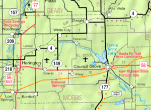 KDOT map of Morris County (legend) | |
| Coordinates: 38°34′33″N 96°21′58″W / 38.57583°N 96.36611°WCoordinates: 38°34′33″N 96°21′58″W / 38.57583°N 96.36611°W | |
| Country | United States |
| State | Kansas |
| County | Morris |
| Area[1] | |
| • Total | 0.23 sq mi (0.60 km2) |
| • Land | 0.23 sq mi (0.60 km2) |
| • Water | 0 sq mi (0 km2) |
| Elevation | 1,184 ft (361 m) |
| Population (2010)[2] | |
| • Total | 30 |
| • Estimate (2015)[3] | 29 |
| • Density | 130/sq mi (50/km2) |
| Time zone | Central (CST) (UTC-6) |
| • Summer (DST) | CDT (UTC-5) |
| ZIP code | 66846 |
| Area code | 620 |
| FIPS code | 20-18950 [4] |
| GNIS feature ID | 0477177 [5] |
Dunlap is a city in Morris County, Kansas, United States. As of the 2010 census, the city population was 30.[6]
History
A post office was established in Hillsborough on March 19, 1874 then renamed to Dunlap on April 20, 1874.[7]
In 1878, Benjamin "Pap" Singleton chose Dunlap as the site for his second Singleton Colony, a community of freedmen who had migrated from Tennessee, because of land available under the Homestead Act. It was named Dunlap after its founder, Joseph Dunlap,[8][9] an Indian agent for the Kaw tribe. Before its present name, the settlement was briefly known as Hillsboro.[10] In the early 1880s, the Presbyterian Church in Dunlap founded the Freedmen's Academy to provide an education to freedmen's families in Kansas. The Academy closed in the mid-1890s.
The post office in Dunlap closed on August 12, 1988.
Geography
Dunlap is located at 38°34′33″N 96°21′58″W / 38.57583°N 96.36611°W (38.575818, -96.366117).[11] According to the United States Census Bureau, the city has a total area of 0.23 square miles (0.60 km2), all of it land.[1]
Climate
The climate in this area is characterized by hot, humid summers and generally mild to cool winters. According to the Köppen Climate Classification system, Dunlap has a humid subtropical climate, abbreviated "Cfa" on climate maps.[12]
Demographics
| Historical population | |||
|---|---|---|---|
| Census | Pop. | %± | |
| 1880 | 247 | — | |
| 1890 | 408 | 65.2% | |
| 1900 | 400 | −2.0% | |
| 1910 | 333 | −16.7% | |
| 1920 | 300 | −9.9% | |
| 1930 | 273 | −9.0% | |
| 1940 | 219 | −19.8% | |
| 1950 | 134 | −38.8% | |
| 1960 | 134 | 0.0% | |
| 1970 | 102 | −23.9% | |
| 1980 | 82 | −19.6% | |
| 1990 | 65 | −20.7% | |
| 2000 | 81 | 24.6% | |
| 2010 | 30 | −63.0% | |
| Est. 2015 | 29 | [3] | −3.3% |
| U.S. Decennial Census | |||
2010 census
As of the census[2] of 2010, there were 30 people, 11 households, and 10 families residing in the city. The population density was 130.4 inhabitants per square mile (50.3/km2). There were 22 housing units at an average density of 95.7 per square mile (36.9/km2). The racial makeup of the city was 96.7% White and 3.3% from two or more races.
There were 11 households of which 27.3% had children under the age of 18 living with them, 63.6% were married couples living together, 9.1% had a female householder with no husband present, 18.2% had a male householder with no wife present, and 9.1% were non-families. 9.1% of all households were made up of individuals. The average household size was 2.73 and the average family size was 2.90.
The median age in the city was 45.5 years. 16.7% of residents were under the age of 18; 16.7% were between the ages of 18 and 24; 16.6% were from 25 to 44; 36.7% were from 45 to 64; and 13.3% were 65 years of age or older. The gender makeup of the city was 60.0% male and 40.0% female.
2000 census
As of the census[4] of 2000, there were 81 people, 25 households, and 21 families residing in the city. The population density was 353.7 people per square mile (136.0/km²). There were 28 housing units at an average density of 122.3 per square mile (47.0/km²). The racial makeup of the city was 95.06% White, 1.23% from other races, and 3.70% from two or more races. Hispanic or Latino of any race were 1.23% of the population.
There were 25 households out of which 52.0% had children under the age of 18 living with them, 72.0% were married couples living together, 12.0% had a female householder with no husband present, and 16.0% were non-families. 16.0% of all households were made up of individuals and 8.0% had someone living alone who was 65 years of age or older. The average household size was 3.24 and the average family size was 3.62.
In the city the population was spread out with 38.3% under the age of 18, 8.6% from 18 to 24, 27.2% from 25 to 44, 18.5% from 45 to 64, and 7.4% who were 65 years of age or older. The median age was 27 years. For every 100 females there were 118.9 males. For every 100 females age 18 and over, there were 100.0 males.
The median income for a household in the city was $42,500, and the median income for a family was $42,500. Males had a median income of $43,750 versus $22,083 for females. The per capita income for the city was $12,939. There were 9.1% of families and 6.3% of the population living below the poverty line, including no under eighteens and none of those over 64.
Education
Primary and secondary education
Dunlap is part of Unified School District 417.[13][14]
Further reading
References
- 1 2 "US Gazetteer files 2010". United States Census Bureau. Retrieved 2012-07-06.
- 1 2 "American FactFinder". United States Census Bureau. Retrieved 2012-07-06.
- 1 2 "Annual Estimates of the Resident Population for Incorporated Places: April 1, 2010 to July 1, 2015". Retrieved July 2, 2016.
- 1 2 "American FactFinder". United States Census Bureau. Retrieved 2008-01-31.
- ↑ "US Board on Geographic Names". United States Geological Survey. 2007-10-25. Retrieved 2008-01-31.
- ↑ "2010 City Population and Housing Occupancy Status". U.S. Census Bureau. Retrieved March 6, 2011.
- ↑ "Kansas Post Offices, 1828-1961". Kansas Historical Society. Retrieved 15 June 2014.
- ↑ Blackmar, Frank Wilson (1912). Kansas: A Cyclopedia of State History, Embracing Events, Institutions, Industries, Counties, Cities, Towns, Prominent Persons, Etc. Standard Publishing Company. p. 553.
- ↑ Gannett, Henry (1905). The Origin of Certain Place Names in the United States. Govt. Print. Off. p. 110.
- ↑ Kansas Place-Names,John Rydjord, University of Oklahoma Press, 1972, ISBN 0-8061-0994-7
- ↑ "US Gazetteer files: 2010, 2000, and 1990". United States Census Bureau. 2011-02-12. Retrieved 2011-04-23.
- ↑ Climate Summary for Dunlap, Kansas
- ↑ USD 417
- ↑ Kansas School District Boundary Map
External links
| Wikimedia Commons has media related to Dunlap, Kansas. |
- City
- Schools
- USD 417, local school district
- Historical
- Matfield Green, A "Quiet" town of Morris County, Kansas, History and photographs.
- Maps
- Dunlap City Map, KDOT
Municipalities and communities of Morris County, Kansas, United States | ||
|---|---|---|
| Cities | 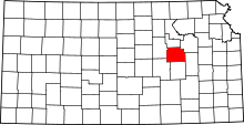 | |
| Unincorporated communities | ||
| Townships |
| |
| Footnotes | ‡This populated place also has portions in an adjacent county or counties | |