Burdick, Kansas
| Burdick, Kansas | |
|---|---|
| Unincorporated community | |
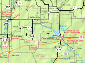 KDOT map of Morris County (legend) | |
 Burdick  Burdick | |
| Coordinates: 38°33′49″N 96°50′44″W / 38.56361°N 96.84556°WCoordinates: 38°33′49″N 96°50′44″W / 38.56361°N 96.84556°W | |
| Country | United States |
| State | Kansas |
| County | Morris |
| Government | |
| • Type | Unincorporated |
| Elevation | 1,453 ft (443 m) |
| Time zone | Central (CST) (UTC-6) |
| • Summer (DST) | CDT (UTC-5) |
| ZIP codes | 66838 |
| Area code(s) | 785 |
| FIPS code | 20-09300 [1] |
| GNIS feature ID | 477148 [1] |
Burdick is an unincorporated community in southwestern Morris County, Kansas, United States. It was named after Ms. Burdick, the sweetheart of a Santa Fe Railroad official in 1887. Burduck is located 6.5 miles (10.5 km) east of Lost Springs, and 12 miles (19 km) from Herington.
History
Early history
For many millennia, the Great Plains of North America was inhabited by nomadic Native Americans. From the 16th century to 18th century, the Kingdom of France claimed ownership of large parts of North America. In 1762, after the French and Indian War, France secretly ceded New France to Spain, per the Treaty of Fontainebleau.
19th century
In 1802, Spain returned most of the land to France. In 1803, most of the land for modern day Kansas was acquired by the United States from France as part of the 828,000 square mile Louisiana Purchase for 2.83 cents per acre.
From the 1820s to the 1870s, one of the most significant land routes in the United States was the Santa Fe Trail. It was located approximately 3 miles (4.8 km) north of Burdick. A large stone stage station, named "Six Mile Stage Station" was built at this location as a rest stop. In 1863, Charles Atkinson witnessed approximately 600 Cheyenne Indians raided this station. DAR Marker #29 was dedicated on October 9, 1908 at this location.[2]
In 1854, the Kansas Territory was organized, then in 1861 Kansas became the 34th U.S. state. In 1859, Morris County was established within the Kansas Territory, which included the land for modern day Burdick.
In 1880, a Swedish settlement called Linsdale was created, consisting of Swedish immigrants from Henry and Mercer counties of Illinois. In 1887, the community name was changed to Burdick, in honor of Ms. Burdick, the sweetheart of a Santa Fe Railroad official.[3]
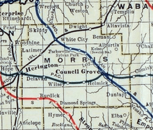
In 1887, Atchison, Topeka and Santa Fe Railway built a branch line from Neva (3 miles west of Strong City) to Superior, Nebraska. This branch line connects Strong City, Neva, Rockland, Diamond Springs, Burdick, Lost Springs, Jacobs, Hope, Navarre, Enterprise, Abilene, Talmage, Manchester, Longford, Oak Hill, Miltonvale, Aurora, Huscher, Concordia, Kackley, Courtland, Webber, Superior. In 2006, the line from Neva to Lost Springs was pulled but the right of way has not been abandoned. This branch line was originally called "Strong City and Superior line" but later the name was shortened to the "Strong City line". In 1996, the Atchison, Topeka and Santa Fe Railway merged with Burlington Northern Railroad and renamed to the current BNSF Railway. Most locals still refer to this railroad as the "Santa Fe".
A post office was established in Burdick on August 29, 1887.[4]
Geography
Burdick is located at 38°33′49″N 96°50′44″W / 38.56361°N 96.84556°W (38.5636222, -96.8455682)[5] at an elevation of 1,453 feet (443 m). It is approximately 6 miles (9.7 km) east of Lost Springs.
Climate
The climate in this area is characterized by hot, humid summers and generally mild to cool winters. According to the Köppen Climate Classification system, Burdick has a humid subtropical climate, abbreviated "Cfa" on climate maps.[6]
Area events
- Annual Burdick Labor Day Weekend Festival
Films
- Bill's Run: A Political Journey in Rural Kansas, a 2004 feature documentary about William Kassebaum running for State Congress, which includes video of the local area.
Economy
Although Burdick is unincorporated, it has a post office with the ZIP code of 66838.[7]
Education
Primary and secondary education
Burdick is part of Unified School District 397.[8] All students attend schools in Lost Springs area.
- Centre High School, located south of Lost Springs in Marion County.
- Centre Junior High School, located south of Lost Springs in Marion County.
- Centre Middle School, located south of Lost Springs in Marion County.
- Centre Grade School, located in Lost Springs in Marion County.
History
In the 1910s, Burdick and Diamond Springs formed a high school district. In 1921, the Diamond Valley High School was completed. The first class graduated in 1923 with 3 students. Due to decreasing attendance, the High School closed its doors in 1957.[9][10]
Infrastructure
Transportation
U.S. Route 77 is 5.0 miles (8.0 km) west, and U.S. Route 56 is 6.5 miles (10.5 km) north of the community.
Utilities
- Internet
- TV
- Satellite TV is provided by DirecTV, Dish Network.
- Free over-the-air ATSC digital TV.
Notable people
- Nancy Kassebaum, United States Senator from 1978 to 1997, lives on a ranch near Burdick.[11]
- William Kassebaum, lawyer, rancher, former member of the Kansas House of Representatives, son of Nancy Landon Kassebaum, brother of Richard Kassebaum.
See also
- Burdick Township, Morris County, Kansas
- National Register of Historic Places listings in Morris County, Kansas
- Santa Fe Trail
Further reading
References
- 1 2 "US Board on Geographic Names". United States Geological Survey. 2007-10-25. Retrieved 2008-01-31.
- ↑ 1997 Survey of DAR Markers in Kansas
- ↑ [Welcome to Burdick, Pop. 60; PBS.org]
- ↑ "Kansas Post Offices, 1828-1961". Kansas Historical Society. Retrieved 15 June 2014.
- ↑ Geographic Names Information System Feature Detail Report, Geographic Names Information System, 1978-10-13. Accessed 2008-04-28.
- ↑ Climate Summary for Burdick, Kansas
- ↑ Zip Code Lookup
- ↑ USD 397
- ↑ Burdick Old & New photos; Photo 3.
- ↑ Burdick Old & New photos; Photo 4.
- ↑ Former senator Nancy Landom Kassebaum calls Flint Hills home; Marion County Record; September 30, 2015.
External links
| Wikimedia Commons has media related to Burdick, Kansas. |
- Schools
- USD 397, Centre school district for Lincolnville, Lost Springs, Pilsen, Tampa, Ramona, Antelope, Burdick, nearby rural areas of Marion / Morris / Dickinson / Chase Counties
- USD 397 School District Boundary Map, KDOT
- Historical
- Welcome to Burdick, Pop. 60, PBS.org
- Photo gallery, then and now, PBS.org
- Burdick History, legendsofkansas.com
- Historic Images of Burdick, Special Photo Collections at Wichita State University Library.
- Maps
- Morris County Maps: Current, Historic, KDOT
- Topo Map of Burdick / Diamond Springs / Delavan area, USGS
Municipalities and communities of Morris County, Kansas, United States | ||
|---|---|---|
| Cities | 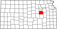 | |
| Unincorporated communities | ||
| Townships |
| |
| Footnotes | ‡This populated place also has portions in an adjacent county or counties | |