Dyersville, Iowa
| Dyersville, Iowa | |
|---|---|
| City | |
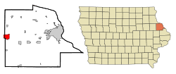 Location in Delaware County and Iowa | |
| Coordinates: 42°28′53″N 91°7′15″W / 42.48139°N 91.12083°WCoordinates: 42°28′53″N 91°7′15″W / 42.48139°N 91.12083°W | |
| Country |
|
| State |
|
| Counties | Dubuque, Delaware |
| Government | |
| • Mayor | Dan Willenborg |
| Area[1] | |
| • City | 5.64 sq mi (14.61 km2) |
| • Land | 5.63 sq mi (14.58 km2) |
| • Water | 0.01 sq mi (0.03 km2) 0.18% |
| Elevation | 951 ft (290 m) |
| Population (2010)[2] | |
| • City | 4,058 |
| • Estimate (2012[3]) | 4,086 |
| • Density | 720.8/sq mi (278.3/km2) |
| • Metro | 92,384 |
| Time zone | CST (UTC-6) |
| • Summer (DST) | CDT (UTC-5) |
| ZIP code | 52040 |
| Area code(s) | 563 |
| FIPS code | 19-23115 |
| GNIS feature ID | 0456086 |
| Website | cityofdyersville.com |
Dyersville is a city in eastern Delaware and western Dubuque counties in the U.S. state of Iowa. It is part of the Dubuque, Iowa, Metropolitan Statistical Area. The population was 4,058 at the 2010 census, up from 4,035 at the 2000 census.
History
Dyersville was laid out in 1851.[4] It was named for early landowner James Dyer.[5]
Attractions
- The baseball field built for the film Field of Dreams.
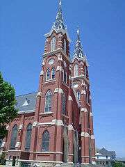
- The Basilica of St. Francis Xavier, one of the few minor Roman Catholic basilicas in the United States outside a large metropolitan area.
- The Ertl Company as well as an outlet store.
- The National Farm Toy Museum.
Geography
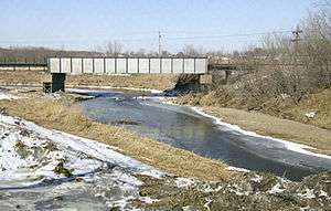
Dyersville is located at 42°28′53″N 91°7′15″W / 42.48139°N 91.12083°W (42.481316, -91.120967),[6] along the North Fork of the Maquoketa River.
According to the United States Census Bureau, the city has a total area of 5.64 square miles (14.61 km2), of which, 5.63 square miles (14.58 km2) is land and 0.01 square miles (0.03 km2) is water.[1]
Demographics
| Historical populations | ||
|---|---|---|
| Year | Pop. | ±% |
| 1880 | 975 | — |
| 1890 | 1,272 | +30.5% |
| 1900 | 1,323 | +4.0% |
| 1910 | 1,511 | +14.2% |
| 1920 | 1,933 | +27.9% |
| 1930 | 2,046 | +5.8% |
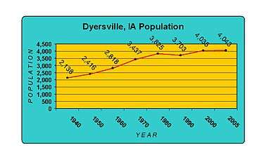
| 1940 | 2,138 | +4.5% |
| 1950 | 2,416 | +13.0% |
| 1960 | 2,818 | +16.6% |
| 1970 | 3,437 | +22.0% |
| 1980 | 3,825 | +11.3% |
| 1990 | 3,696 | −3.4% |
| 2000 | 4,035 | +9.2% |
| 2010 | 4,058 | +0.6% |
| 2014 | 4,149 | +2.2% |
| 2015 | 4,204 | +1.3% |
| Source:"American FactFinder". United States Census Bureau. and Iowa Data Center Source: | ||
2010 census
As of the census[2] of 2010, there were 4,058 people, 1,700 households, and 1,102 families residing in the city. The population density was 720.8 inhabitants per square mile (278.3/km2). There were 1,808 housing units at an average density of 321.1 per square mile (124.0/km2). The racial makeup of the city was 97.6% White, 0.9% African American, 0.2% Asian, 0.4% from other races, and 0.8% from two or more races. Hispanic or Latino of any race were 1.3% of the population.
There were 1,700 households of which 29.4% had children under the age of 18 living with them, 55.3% were married couples living together, 6.5% had a female householder with no husband present, 3.0% had a male householder with no wife present, and 35.2% were non-families. 29.9% of all households were made up of individuals and 14.2% had someone living alone who was 65 years of age or older. The average household size was 2.36 and the average family size was 2.94.
The median age in the city was 40.6 years. 24.6% of residents were under the age of 18; 6.7% were between the ages of 18 and 24; 24.4% were from 25 to 44; 24.6% were from 45 to 64; and 19.6% were 65 years of age or older. The gender makeup of the city was 48.5% male and 51.5% female.
2000 census
As of the census[8] of 2000, there were 4,035 people, 1,578 households, and 1,117 families residing in the city. The population density was 878.1 people per square mile (338.7/km²). There were 1,669 housing units at an average density of 363.2 per square mile (140.1/km²). The racial makeup of the city was 98.71% White, 0.45% African American, 0.17% Pacific Islander, 0.12% Asian, 0.05% from other races, and 0.50% from two or more races. Hispanic or Latino of any race were 0.45% of the population.
There were 1,578 households out of which 35.4% had children under the age of 18 living with them, 61.0% were married couples living together, 7.8% had a female householder with no husband present, and 29.2% were non-families. 25.7% of all households were made up of individuals and 13.2% had someone living alone who was 65 years of age or older. The average household size was 2.52 and the average family size was 3.07.
28.0% are under the age of 18, 6.7% from 18 to 24, 29.1% from 25 to 44, 18.5% from 45 to 64, and 17.7% who were 65 years of age or older. The median age was 36 years. For every 100 females there were 91.2 males. For every 100 females age 18 and over, there were 88.8 males.
The median income for a household in the city was $38,469, and the median income for a family was $45,625. Males had a median income of $29,674 versus $21,312 for females. The per capita income for the city was $17,195. About 4.6% of families and 4.8% of the population were below the poverty line, including 5.5% of those under the age of 18 and 8.4% of those 65 and older.
Law and government
Dyersville's current Mayor is Dan Willenborg. Dyersville is represented by Senator Pam Jochum (D-Dubuque) in the Iowa Senate, and Representative Nancy Dunkel (D-Dyersville) in the Iowa House of Representatives. At the federal level, it is within Iowa's 1st congressional district, represented by Rod Blum (R) in the U.S. House of Representatives. Dyersville, and all of Iowa, are represented by U.S. Senators Chuck Grassley (R) and Joni Ernst (R)
Education
All public school students living in Dyersville are zoned to schools in the Western Dubuque Community School District. Elementary school students first attend Dyersville Elementary School (in Dyersville) for grades K-4, then go to Drexler Elementary School in nearby Farley, Iowa for grade 5. Middle school students are zoned to Drexler Middle School (also in Farley), and high school students are zoned to Western Dubuque High School in Epworth, Iowa.
Dyersville also has thriving private schools. Parochial school students attend St. Francis Xavier Elementary School for grades PreK-6, then go to Beckman Catholic High School for grades 7-12, both of which are in Dyersville. These schools are both affiliated with the Roman Catholic Church, and are a part of the Roman Catholic Archdiocese of Dubuque.
Economy
Dyersville is a thriving farming city with a long history. It is nicknamed "The Farm Toy Capital of the World" because it hosts a farm toy show the first weekend in June and the National Farm Toy Show the first weekend in November.[9] It is also the longtime home of the Ertl Company, a maker of die-cast farm toys. Multiple local businesses are based on this part of its economy.
Largest employers
The ten largest employers (by number of employees) in descending order, as of 2016.[10]
- FarmTek - distributor of farm supplies and manufacturer of tension fabric buildings.
- Modernfold - operable and moveable walls and folding doors.
- Lumber Specialties - floor and roof trusses and wall panels.
- Dyersville Die-Cast - custom manufacturer of zinc and aluminum die-casting, CNC machining, powder coating and scale model toys.
- TOMY - branded toys, collectibles, hobby and infant products.
- Spireon - mobile resource management.
- All American Homes - manufacturer of modular homes and apartments.
- BARD Materials - ready-mix concrete (ag lime, crushed rock, sand).
- Mercy Medical Center - acute hospital services, nursing, nursing home, assisted and independent living facilities, physical therapy.
- Beckman Catholic High School - grades 7-12.
Notable people
The photographer George Strock was born in Dyersville.
References
- 1 2 "US Gazetteer files 2010". United States Census Bureau. Retrieved 2012-05-11.
- 1 2 "American FactFinder". United States Census Bureau. Retrieved 2012-05-11.
- ↑ "Population Estimates". United States Census Bureau. Retrieved 2013-05-23.
- ↑ The History of Dubuque County, Iowa, Containing a History of the County, Its Cities, Towns, &c. Western Historical. 1880. p. 703.
- ↑ Gannett, Henry (1905). The Origin of Certain Place Names in the United States. Govt. Print. Off. p. 112.
- ↑ "US Gazetteer files: 2010, 2000, and 1990". United States Census Bureau. 2011-02-12. Retrieved 2011-04-23.
- ↑ "Census of Population and Housing". Census.gov. Retrieved June 4, 2015.
- ↑ "American FactFinder". United States Census Bureau. Retrieved 2008-01-31.
- ↑ Daniels, Donna (4 May 2007). "Farm Toy Capital of the World: Find Out About Toys in Dyersville, Iowa". Yahoo! Contributor Network. Retrieved 4 March 2013.
- ↑ "Top 10 Employers". Dyersville Area Chamber of Commerce. Retrieved 16 March 2016.
External links
| Wikimedia Commons has media related to Dyersville, Iowa. |
- City of Dyersville
- Dyersville Area Chamber of Commerce
- Dyersville Economic Development Corporation
- Greater Dubuque Development Corporation
- Prosperity Eastern Iowa
Municipalities and communities of Delaware County, Iowa, United States | ||
|---|---|---|
| Cities | ||
| Townships | ||
| Unincorporated communities | ||
| Footnotes | ‡This populated place also has portions in an adjacent county or counties | |
Municipalities and communities of Dubuque County, Iowa, United States | ||
|---|---|---|
| Cities | ||
| Townships | ||
| Unincorporated communities | ||
| Footnotes | ‡This populated place also has portions in an adjacent county or counties | |