Fairview Park, Indiana
| Fairview Park | |
|---|---|
| Town | |
 Vermillion County's location in Indiana | |
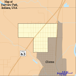 Map of Fairview Park | |
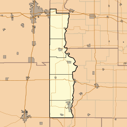 Fairview Park Fairview Park's location in Vermillion County | |
| Coordinates: 39°40′54″N 87°24′49″W / 39.68167°N 87.41361°WCoordinates: 39°40′54″N 87°24′49″W / 39.68167°N 87.41361°W | |
| Country | United States |
| State | Indiana |
| County | Vermillion |
| Township | Clinton |
| Area[1] | |
| • Total | 0.88 sq mi (2.28 km2) |
| • Land | 0.88 sq mi (2.28 km2) |
| • Water | 0 sq mi (0 km2) |
| Elevation[2] | 512 ft (156 m) |
| Population (2010)[3] | |
| • Total | 1,386 |
| • Estimate (2012[4]) | 1,375 |
| • Density | 1,575.0/sq mi (608.1/km2) |
| Time zone | EST (UTC-5) |
| • Summer (DST) | EST (UTC-5) |
| ZIP code | 47842 |
| Area code(s) | 765 |
| FIPS code | 18-22576[5] |
| GNIS feature ID | 434349 |
| Website |
fpi |
Fairview Park is a town in Clinton Township, Vermillion County, Indiana, United States.[6] The population was 1,386 at the 2010 census.
History
Fairview Park was platted in 1902.[7]
Geography
Fairview Park is located in the southeastern part of the county, at the north end of the city of Clinton. Indiana State Road 63 passes through the town from northeast to southwest.
According to the 2010 census, Fairview Park has a total area of 0.88 square miles (2.28 km2), all land.[1]
Climate
The climate in this area is characterized by hot, humid summers and generally mild to cool winters. According to the Köppen Climate Classification system, Fairview Park has a humid subtropical climate, abbreviated "Cfa" on climate maps.[8]
Demographics
| Historical population | |||
|---|---|---|---|
| Census | Pop. | %± | |
| 1910 | 630 | — | |
| 1920 | 1,301 | 106.5% | |
| 1930 | 1,106 | −15.0% | |
| 1940 | 1,074 | −2.9% | |
| 1950 | 902 | −16.0% | |
| 1960 | 1,039 | 15.2% | |
| 1970 | 1,067 | 2.7% | |
| 1980 | 1,545 | 44.8% | |
| 1990 | 1,446 | −6.4% | |
| 2000 | 1,496 | 3.5% | |
| 2010 | 1,386 | −7.4% | |
| Est. 2015 | 1,333 | [9] | −3.8% |
2010 census
As of the census[3] of 2010, there were 1,386 people, 609 households, and 406 families residing in the town. The population density was 1,575.0 inhabitants per square mile (608.1/km2). There were 676 housing units at an average density of 768.2 per square mile (296.6/km2). The racial makeup of the town was 98.2% White, 0.1% African American, 0.1% Native American, 0.2% Asian, 0.1% Pacific Islander, 0.6% from other races, and 0.5% from two or more races. Hispanic or Latino of any race were 0.8% of the population.
There were 609 households of which 26.4% had children under the age of 18 living with them, 54.4% were married couples living together, 9.2% had a female householder with no husband present, 3.1% had a male householder with no wife present, and 33.3% were non-families. 29.7% of all households were made up of individuals and 11.6% had someone living alone who was 65 years of age or older. The average household size was 2.28 and the average family size was 2.78.
The median age in the town was 41.9 years. 20.9% of residents were under the age of 18; 7.7% were between the ages of 18 and 24; 23.2% were from 25 to 44; 31.2% were from 45 to 64; and 16.9% were 65 years of age or older. The gender makeup of the town was 50.7% male and 49.3% female.
2000 census
As of the census[5] of 2000, there were 1,496 people, 634 households, and 436 families residing in the town. The population density was 1,652.4 people per square mile (634.7/km²). There were 680 housing units at an average density of 751.1 per square mile (288.5/km²). The racial makeup of the town was 96.66% White, 0.53% African American, 0.13% Native American, 0.60% from other races, and 2.07% from two or more races. Hispanic or Latino of any race were 1.40% of the population.
There were 634 households out of which 29.8% had children under the age of 18 living with them, 56.9% were married couples living together, 9.3% had a female householder with no husband present, and 31.1% were non-families. 26.7% of all households were made up of individuals and 9.5% had someone living alone who was 65 years of age or older. The average household size was 2.36 and the average family size was 2.86.
In the town the population was spread out with 22.4% under the age of 18, 8.6% from 18 to 24, 27.4% from 25 to 44, 28.1% from 45 to 64, and 13.5% who were 65 years of age or older. The median age was 40 years. For every 100 females there were 97.9 males. For every 100 females age 18 and over, there were 94.1 males.
The median income for a household in the town was $36,078, and the median income for a family was $43,542. Males had a median income of $39,000 versus $21,667 for females. The per capita income for the town was $21,459. About 8.2% of families and 10.1% of the population were below the poverty line, including 14.4% of those under age 18 and 8.1% of those age 65 or over.
Law enforcement and fire protection
The Fairview Park Town Marshal's Office provides law enforcement to the town and the city of Clinton per request. Fire protection is covered by the Fairview Park Fire Department. The fire house shares a building with the town hall located at 281 S Washington Street.
Notable people
- Len Gilmore, pitcher in Major League Baseball
References
- 1 2 "G001 - Geographic Identifiers - 2010 Census Summary File 1". United States Census Bureau. Retrieved 2015-07-16.
- ↑ "US Board on Geographic Names". United States Geological Survey. 2007-10-25. Retrieved 2008-01-31.
- 1 2 "American FactFinder". United States Census Bureau. Retrieved 2012-12-11.
- ↑ "Population Estimates". United States Census Bureau. Retrieved 2013-06-25.
- 1 2 "American FactFinder". United States Census Bureau. Retrieved 2008-01-31.
- ↑ "Fairview Park, Indiana". Geographic Names Information System. United States Geological Survey. Retrieved 2016-07-15.
- ↑ History of Parke and Vermillion Counties, Indiana. B.F. Bowen & Cos. 1913. p. 393.
- ↑ Climate Summary for Fairview Park, Indiana
- ↑ "Annual Estimates of the Resident Population for Incorporated Places: April 1, 2010 to July 1, 2015". Retrieved July 2, 2016.
- ↑ "Census of Population and Housing". Census.gov. Retrieved June 4, 2015.
External links
Municipalities and communities of Vermillion County, Indiana, United States | ||
|---|---|---|
| City | ||
| Towns | ||
| Townships | ||
| CDPs | ||
| Other unincorporated communities | ||
| Ghost towns | ||
| Footnotes | ‡This populated place also has portions in an adjacent county or counties | |