Fujinuma Dam
| Fujinuma Dam | |
|---|---|
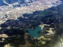 Fujinuma Reservoir in 2009 with dam at center bottom, auxiliary dam on left edge of reservoir | |
| Country | Japan |
| Location | Sukagawa City |
| Coordinates | 37°18′07″N 140°11′41″E / 37.30194°N 140.19472°ECoordinates: 37°18′07″N 140°11′41″E / 37.30194°N 140.19472°E |
| Status | Failed |
| Opening date | 1949 |
| Demolition date | 11 March 2011 |
| Owner(s) | Ebana River Coastal Reclamation District |
| Dam and spillways | |
| Type of dam | Embankment |
| Impounds | Ebana River |
| Height | 18.5 m (61 ft) |
| Length | 133 m (436 ft) |
| Width (crest) | 6 m (20 ft) |
| Dam volume | 99,000 m3 (3,496,152 cu ft) |
| Reservoir | |
| Creates | Fujinuma Reservoir |
| Total capacity | 1,504,000 m3 (1,219 acre·ft) |
| Catchment area | 8.8 km2 (3 sq mi) |
| Surface area | 20 ha (49 acres) |
The Fujinuma Dam (藤沼ダム Fujinuma Damu),[1] was an earth-fill embankment dam in Sukagawa City, Fukushima Prefecture, Japan. It was established on the Ebana River, a tributary of the Abukuma River, 16 km (10 mi) west of the city office of Sukagawa City. Construction on the dam commenced in 1937 and it was completed in 1949 after construction was halted due to World War II.[2] The dam's primary purpose was irrigation. It failed on 11 March 2011 after the 2011 Tōhoku earthquake.
Failure
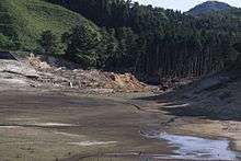
On 11 March 2011, the dam failed 20 to 25 minutes after the Tōhoku earthquake as the nearly full reservoir overtopped the dam's crest. Locals reported hearing a loud burst before seeing a flood.[2] The flood washed away five houses while damaging others, disabling a bridge and blocked roads with debris. Eight people were missing and four bodies were discovered after searches began at dawn.[3][4][5]
On 12 March, 252 dams were inspected and seven dams were found to be damaged. Six embankment dams had shallow cracking on their crests and the reservoir at one concrete gravity dam had a slight slope failure. Four dams, including the Fujinuma, were inaccessible and could not be inspected.[6]
A preliminary survey of the dam and facilities conducted in April 2011 noted that the breach occurred at the tallest section of the dam.[7] Within the dam's fill, there were layers of organic residual soil that in one area contained a tree stump. The residual soil was used as foundation and in layers as well — above alluvium. This suggests that the foundation for the dam was not prepared properly, according to the study. In addition, the reservoir's auxiliary dam suffered a severe slope failure on its upstream face while areas around the rim of the reservoir had mild slope failures or distress. It could not be confirmed whether the earthquake or a quick draining of the reservoir was the cause of this.[2]
Design
The dam was a 18.5 m (61 ft) tall and 133 m (436 ft) long embankment-type with a structural volume of 99,000 m3 (3,496,152 cu ft) and crest width of 6 m (20 ft). About 300 m (984 ft) to the south, there is an auxiliary dam with a height of about 6 m (20 ft) and length of approximately 60 m (197 ft).[2] The auxiliary dam helped the reservoir maintain it designed levels given the topography wouldn't allow the single main dam to do so. The dam sat at the head of a 8.8 km2 (3 sq mi) drainage area and its reservoir had a capacity of 1,504,000 m3 (1,219 acre·ft). The reservoir had a surface area of 20 ha (49 acres). The dam was built by Shoji Kensetsu and operated by Ebana River Coastal Reclamation District.[1]
See also
References
- 1 2 "Fujinuma Dam - Dam Handbook" (in Japanese). Dam Association of Japan. Retrieved 14 March 2011.
- 1 2 3 4 Harder, Leslie F.; Keith I. Kelson; Tadahiro Kishida; Robert Kayen (6 June 2011). "Preliminary Observations of the Fujinuma Dam Failure Following the March 11, 2011 Tohoku Offshore Earthquake, Japan" (PDF). Geotechnical Extreme Events Reconnaissance (GEER). GEER Association. Retrieved 15 July 2011.
- ↑ "Dam Breaks In Northeast Japan, Washes Away Homes". Arab Times. 12 March 2011. Retrieved 14 March 2011.
- ↑ Azuma, Kita (12 March 2011). "Pacific Ocean coast Earthquake" (in Japanese). MSN. Retrieved 14 March 2011.
- ↑ ダム決壊 5棟流出 福島・須賀川 (in Japanese). Kahoku Shimpo. 13 March 2011. Retrieved 14 March 2011.
- ↑ "A quick report on Japanese Dams after the Earthquake". Chinese National Committee on Large Dams. 13 March 2011. Retrieved 15 March 2011.
- ↑ Kayen, Robert E.; YasuoTanaka; Tanaka, Hajime; Sugano, Takahiro; Estevez, Ivan A.; Cullenward, Sean S.; Yeh, Winnie; Thomas, Davis (20 July 2011). "LiDAR and Field Investigation Of the March 11, 2011 M9.0 Great Tohoku Offshore Earthquake, and April 7, 2011 M7.4 Aftershock" (PDF). Geotechnical Extreme Events Reconnaissance (GEER). GEER Association. Retrieved 20 July 2011.
| Geology | |||||||||||||
|---|---|---|---|---|---|---|---|---|---|---|---|---|---|
| Affected areas | |||||||||||||
| Affected infrastructure | |||||||||||||
| Nuclear accidents | |||||||||||||
| Aftershocks |
| ||||||||||||
| People | |||||||||||||
| Fundraisers | |||||||||||||
| Other | |||||||||||||