Iwaki, Fukushima
| Iwaki いわき市 | |||
|---|---|---|---|
| Core city | |||
|
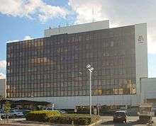
Top: Iwaki Yumoto Onsen, Aquamarine Fukushima Middle: Iwaki Velodrome, Iwaki Green Stadium Bottom: Spa Resort Hawaiian, Iwaki Marine Tower | |||
| |||
|
Location of Iwaki in Fukushima Prefecture | |||
 Iwaki
| |||
| Coordinates: 37°3′1.8″N 140°53′15.8″E / 37.050500°N 140.887722°ECoordinates: 37°3′1.8″N 140°53′15.8″E / 37.050500°N 140.887722°E | |||
| Country | Japan | ||
| Region | Tōhoku | ||
| Prefecture | Fukushima Prefecture | ||
| Government | |||
| • - Mayor | Toshio Shimizu (since September 2013) | ||
| Area | |||
| • Total | 1,231.35 km2 (475.43 sq mi) | ||
| Population (February 2015) | |||
| • Total | 325,914 | ||
| • Density | 265/km2 (690/sq mi) | ||
| Time zone | Japan Standard Time (UTC+9) | ||
| - Tree | Japanese Black Pine | ||
| - Flower | Azalea | ||
| - Bird | Seagull | ||
| - Fish | Greeneyes | ||
| Phone number | 024-622-1111 | ||
| Address | 21 Umemoto, Taira, Iwaki-shi, Fukushima-ken 970-8686 | ||
| Website |
www | ||

Iwaki (いわき市 Iwaki-shi) is a city located in the southern part of the Hamadōri coastal region of Fukushima Prefecture, Japan.
A designated core city, Iwaki is also one of the growing number of hiragana cities. Its total area is 1,231.35 km²,[1] making it the 10th largest city in Japan (2010). Its estimated population as of May 2011 is 337,288,[2] making it the biggest city of the prefecture. Iwaki has a population density of 270 persons per km².
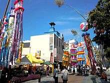
The present "Iwaki City" started as the merger of 14 municipalities on October 1, 1966. The city was the third hiragana city, following Chino, Nagano and Mutsu, Aomori. The area was the largest in Japan at the time. The city works as an industrial hub of Tōhoku region, and is rich in sightseeing resources. As of 2005, about 7.6 million sightseers visit the city a year. Every year Iwaki hosts the Taira Tanabata Festival from 6–8 August.[3]
History
The forms いわき, 石城, 岩城, 巖城, 巌城, and 磐城 are all ways of writing "Iwaki," which means "rocky castle". Today, いわき is the most common written form.
Under the Taika Reform of 645 AD, the central government formed "Iwaki district (磐城郡)" in the northern part of the present city and "Kikuta district (菊多郡)" in the southern part.[4] In 653, the Iwaki district incorporated part of Taga Province and became Iwaki district(岩城評).[4] In 718, Iwaki Province was formed, which was composed of five districts with Mutsu Province: Iwaki (岩城), Shineha, Namekata, Uta, Watari and Kikuta which was given from Hitachi Province. Shineha was the present Naraha. Namekata and Uta were the present Soma. Watari was the present Watari, Miyagi. The area of the present Iwaki City was composed of Kikuta and Iwaki (岩城 or 磐城).[4]
Iwaki's origin dates back to 708 AD, during the Nara period. The Yamato government constructed the Nakoso barrier against possible invasion by the Emishi tribes in the north.[5]
In the late 11th century, the Iwaki clan (岩城氏) of Hitachi Province invaded Iwaki district (磐城郡) and divided it into four districts of Yoshima, Iwasaki, Iwaki, Naraha. The clan made Iwaki district its headquarters and ruled the area from the Kamakura period to the end of the Sengoku period.
In 1600, Iwaki Sadataka (岩城貞隆) opposed Tokugawa Ieyasu during the Battle of Sekigahara and as a result, the Iwaki clan was deposed. Torii Tadamasa was appointed as daimyo of Iwakitaira Domain under the Tokugawa shogunate, with an income assessed at 100,000 koku.[4]
In 1603 Edo period, Torii Tadamasa started to construct Iwakitaira Castle in Taira. Other feudal domains, Izumi Domain (1634) and Yunagaya Domain (1670), were also created within the boundaries of the present day city of Iwaki. All of these domains joined the Ōuetsu Reppan Dōmei during the Bakumatsu period in support of the Tokugawa against the Satcho Alliance during the Boshin War, but following the Meiji restoration, all of the daimyo were dispossessed in 1871 with the Abolition of the han system. The new Meiji government created Iwakitaira Prefecture, Yunagaya Prefecture and Izumi Prefecture, which were incorporated to Iwamae (Iwasaki) Prefecture (磐前県) and to the current Fukushima Prefecture (1876).[4] In 1896, Iwaki Bank and Taira Bank were established.
In 1897, the Japanese Government Railway filled in the inner moat of Iwakidaira Castle and made Taira Station. Jōban coalfield, the largest coalfield in Honshū and the nearest to the Japanese capital Tokyo, was developed, and the population of Taira increased to support the exploitation of the coalfield. The Jōban Line was made for the haulage of the coal. Iwaki's fishery, forestry and agricultural sectors also developed from this time.[5] After World War II, the Jōban coalfield was closed. The same natural hot springs that were troublesome to the coal miners were put to good use and a hot springs resort was developed Spa Resort Hawaiians.
The present city was incorporated on October 1, 1966, with the merger of 14 municipalities (5 cities, 4 towns and 5 villages). The cities were Taira (平), Uchigō (内郷), Iwaki (磐城), Nakoso (勿来), and Jōban (常磐); the towns, Yotsukura, (四倉) Tōno (遠野), Ogawa (小川) and Hisanohama (久之浜); and the five villages were Yoshima (好間), Miwa (三和), Tabito (田人), Kawamae (川前) and Ōhisa (大久).[4] Taira was chosen as the location for City Hall and other administrative offices and continues to function as the centre of Iwaki. In April 1979, an "Iwaki Number" as an automobile number plate was introduced.
On April 1, 1999, the city was designated a core city.
Geography and climate
The city is located at the southern end of Tōhoku region and close to Ibaraki Prefecture, (37°01′N 140°32′E / 37.02°N 140.53°E). The city covers a total area of 1,231.35 km², making it the largest city in Fukushima Prefecture and the tenth largest in Japan. The city occupies around 8.9 percent of the total area of Fukushima Prefecture.
The eastern part of the city is made up of 60 kilometres of coastline which faces the Pacific Ocean and the western part goes through the Abukuma highlands and joins up with the central part of Fukushima Prefecture. The western part is a range of mountains and forests, occupies about 70 percent of the city. The rivers which flow to the east from the mountains have riverbeds with steep inclines which form the deep valleys of the Natsuigawa Gorge and the Shidokigawa Gorge. The flatter eastern part of the city is where most of the population is located. There are seven beaches on the coastline. Off the coast of Iwaki the Kuroshio Current(warm) and the Oyashio Current(cold) meet and make for an abundant fishing ground. The prevailing winds from the ocean are warm and wet.
Neighboring municipalities
Climate
Iwaki is situated in a temperate climate zone (Köppen climate classification Cfa) and has a moderate climate. The city's average temperature is 13.1 °C (55.6 °F) and its average annual precipitation is 1,383.0 mm. The highest recorded temperature in the city is 37.7 °C (99.9 °F), and the lowest recorded temperature is -10.7 °C (12.7 °F). The average year has 14.4 days with a high temperature over 25 °C and only 3.1 days with a low temperature below 0 °C, which is smaller compared to other Japanese cities. The city is rarely hit by typhoons, and experiences only 0.7 days with more than 10 cm of snowfall in the average year. The duration of bright sunshine is 2058.1 hours in average year.[6]
| Climate data for Onahama, Iwaki, Fukushima | |||||||||||||
|---|---|---|---|---|---|---|---|---|---|---|---|---|---|
| Month | Jan | Feb | Mar | Apr | May | Jun | Jul | Aug | Sep | Oct | Nov | Dec | Year |
| Average high °C (°F) | 8.1 (46.6) |
8.0 (46.4) |
10.3 (50.5) |
15.1 (59.2) |
18.9 (66) |
21.5 (70.7) |
24.6 (76.3) |
27.3 (81.1) |
24.5 (76.1) |
19.9 (67.8) |
15.4 (59.7) |
10.8 (51.4) |
17.03 (62.65) |
| Daily mean °C (°F) | 3.1 (37.6) |
3.3 (37.9) |
5.8 (42.4) |
10.8 (51.4) |
15.1 (59.2) |
18.2 (64.8) |
21.5 (70.7) |
23.9 (75) |
20.9 (69.6) |
15.6 (60.1) |
10.5 (50.9) |
5.7 (42.3) |
12.87 (55.16) |
| Average low °C (°F) | −1.5 (29.3) |
−1.0 (30.2) |
1.4 (34.5) |
6.4 (43.5) |
11.3 (52.3) |
15.4 (59.7) |
19.1 (66.4) |
21.1 (70) |
17.8 (64) |
11.4 (52.5) |
5.6 (42.1) |
0.7 (33.3) |
8.98 (48.15) |
| Average precipitation mm (inches) | 45.0 (1.772) |
62.1 (2.445) |
102.8 (4.047) |
128.2 (5.047) |
146.1 (5.752) |
156.5 (6.161) |
113.0 (4.449) |
137.5 (5.413) |
175.4 (6.906) |
162.3 (6.39) |
87.6 (3.449) |
40.3 (1.587) |
1,356.8 (53.418) |
| Average snowfall cm (inches) | 4 (1.6) |
8 (3.1) |
3 (1.2) |
0 (0) |
0 (0) |
0 (0) |
0 (0) |
0 (0) |
0 (0) |
0 (0) |
0 (0) |
1 (0.4) |
16 (6.3) |
| Average relative humidity (%) | 60 | 60 | 63 | 71 | 77 | 84 | 87 | 85 | 81 | 75 | 70 | 64 | 73.1 |
| Mean monthly sunshine hours | 188.3 | 169.8 | 191.3 | 184.0 | 201.0 | 144.0 | 147.6 | 192.9 | 130.3 | 152.0 | 156.6 | 177.1 | 2,034.9 |
| Source: NOAA (1961-1990) [7] | |||||||||||||
Natural environment
- Rivers: Natsuigawa River, Samegawa River, Yoshimagawa River, Fujiwara River
- Gorges: Natsuigawa Gorge, Shidokigawa Gorge
- Mountains: Mizuishiyama, Yunodake, Futatsuyasan, Ishimoriyama
- Hot springs: Iwaki Yumoto Onsen
Subdivisions
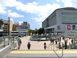
The central area of Iwaki is the former city of Taira, which has Iwaki City Hall, Iwaki City Lyceum, Iwaki Station, etc. Iwaki is a decentralized city and consists of several other urban areas including Onahama and Yumoto, which were previously independent cities, towns or villages.
Yumoto is home to Iwaki Yumoto Onsen, one of the oldest onsen in Japan, with many ryokan hotels. It is also home to Spa Resort Hawaiians, a spa resort which draws 1.5 million visitors per year and was the subject of the 2006 movie Hula Girls.
Onahama is a port town where many factories, fisheries and port facilities are located. There is also an aquarium, some beaches and seaside restaurants.
Izumi is a residential area. Ueda, Nakoso, Uchigō, Yotsukura and other areas are more rural.
There are thirteen zones (hamlets or 大字 (ooaza)) within the city.[8]
- Taira
- Onahama & Ena & Izumi
- Nakoso & Nishiki & Ueda
- Jōban & Yumoto
- Uchigō
- Yotsukura
- Tōno
- Ogawa
- Yoshima
- Miwa
- Tabito
- Kawamae
- Hisanohama & Ōhisa
Demographics
As of October 1, 2007, Iwaki had an estimated population of 350,119, giving a population density of 284.33 persons per km². Iwaki is the second most populous city in the Tōhoku region, following Sendai, and the 59th most populous nationwide. The conurbation is the third biggest in the prefecture, following Kōriyama and Fukushima.
As of 2007, Iwaki City has 130,814 households. The average household has approximately 2.67 members. The number of males is 169,932 and the number of females is 180,187. The city has many people in their 50s and in their 40s compared to other age groups. The average age in Iwaki is 44.31.
| Zone | Population | Households | Area (km²) | Population density (/km²) |
|---|---|---|---|---|
| Taira | 99,901 | 38,685 | 109.88 | 909.18 |
| Onahama | 77,857 | 29,182 | 87.64 | 888.37 |
| Nakoso | 51,783 | 18,651 | 104.74 | 494.39 |
| Jōban | 35,904 | 13,550 | 48.23 | 744.43 |
| Uchigō | 28,214 | 11,462 | 31.62 | 892.28 |
| Yotsukura | 15,686 | 5,284 | 63.73 | 246.13 |
| Tōno | 6,404 | 1,913 | 104.53 | 61.26 |
| Ogawa | 7,567 | 2,481 | 112.49 | 67.26 |
| Yoshima | 13,597 | 5,319 | 26.69 | 509.44 |
| Miwa | 3,676 | 1,107 | 214.90 | 17.10 |
| Tabito | 2,117 | 713 | 158.07 | 13.39 |
| Kawamae | 1,448 | 509 | 116.44 | 12.43 |
| Hisanohama, Ōhisa | 5,965 | 1,958 | 52.38 | 113.87 |
| Total | 350,119 | 130,814 | 1,231.34 | 284.33 |
As of October 1, 2007 [9]
Economy
The main foundations of economy are industry and agriculture. In particular, Iwaki is a centre for manufacturing machinery, wood based products and chemicals. The industrial production of Iwaki City is no.1 in Tōhoku region. Iwaki is rich in sightseeing resources and 7.64 million tourists visit annually. Within Fukushima prefecture, the industrial and sightseeing center is Iwaki, while the political center is Fukushima city.
Statistics (2006)[10]
- Employed population: 174,048
- Unemployed population: 121,802
- Gross production: ¥1,293,782 billion
- Number of tourists: 7,639,296
Major companies
Major companies with head offices in Iwaki
Major companies with factories in Iwaki
- Alps Electric Co. & Alpine Electronics; TYO1
- Arakawa Chemical Industries, Ltd; TYO1, OSE1
- S. T. Corporation (old S.T. Chemistry); TYO1
- Okamoto Industries, Inc.; TYO1
- Cleanup Corporation; TYO1
- Kureha Corporation; TYO1, OSE1
- Mazda; TYO1
- Nissan Motors; TYO1
- Organo Corp.; TYO1
- Mitsubishi Materials Corporation; TYO1
- Aska Pharmaceutical Co., Ltd.; TYO1
- Nichiha Corporation; NSE1, TYO1
- Nippon Paper Industries Co., Ltd.
- Merck KGaA; DAX
- Merck & Co.; NYSE
Banks
(As of 2007)
- Iwaki Credit Association
- Himawari Credit Association
- Toho Bank
- Fukushima Bank
- Daito Bank
- Joyo Bank
- The 77 Bank
- Tohoku Industrial Bank
- Abukuma Trust Bank
- Akita Bank
- Mizuho Bank
- National Life Finance Corporation
Fisheries
- Fishery: 75,628t (2003)
Import and export
Onahama Port (2003)
- Import: 5,133,727t
- Export: 514,045t
Transportation
Surrounded by the ocean and mountains, Iwaki is more closely connected to Mito in neighboring Ibaraki Prefecture than to Nakadōri (Kōriyama or the prefectural capital of Fukushima). Iwaki is 75 km from Kōriyama, 150 km from Sendai and 95 km from Mito. Most residents use cars to commute as Iwaki is large and urban areas are dispersed.
The Jōban Line runs north and south in the city. The central station is Iwaki station (old Taira station). The East Ban'etsu Line links to Koriyama.
Railway
- Central Station: Iwaki Station
- JR East - Jōban Line
- JR East - East Ban'etsu Line
- Fukushima Rinkai Railway Company - Fukushima Seaside Line (freight line)
- Izumi - Onahama
- ¤This line carries passenger specially on the day of Onahama firework festival
Roads

- Jōban Expressway - Iwaki Nakoso - Iwaki Yumoto - Iwaki JCT - Iwaki Chūō IC - Iwaki Yotsukura
- Ban-etsu Expressway - Iwaki JCT - Iwaki Miwa
- Japan National Route 6
- Japan National Route 49
- Japan National Route 289
- Japan National Route 349
- Japan National Route 399
Bus operators
City buses
- Shin Jōban Kōtsū
Highway buses
- Shin Jōban Kōtsū
- JR Bus Tohoku
- JR Bus Kanto
- Tōbu Bus Central
- Fukushima Transportation
- Aizu Bus
Ports
- Onahama Port, designated as an important port by Japan
- Nakanosaku Port
- Ena Port
- Hisanohama Port
Airport
Fukushima Airport in Sukagawa is the nearest airport.
Sport
Iwaki-Taira Velodrome is located within the city.
Public institutions
Taira
- Iwaki City Hall (main)
- Iwaki Green Stadium
- Iwaki athletic field
- Iwaki civil pools
- Iwaki gymnasium
- Iwaki Velodrome
- Iwaki Lyceum "Alios"
- Iwaki cultural center
- Iwaki central library
- Iwaki museum
- Iwaki central park
Nakoso
- Nakoso branch office
- Iwaki Nakoso Lyceum
Uchigō
- Uchigō branch office
- Iwaki Uchigō Community Center
Onahama
- Onahama branch office
- Iwaki Onahama baseball ground
- Onahama civil pools
- Iwaki Onahama Lyceum
- Aquamarine Fukushima
Jōban (Yumoto)
- Jōban branch office
- The 21st-century forest park
- Iwaki Green Stadium (capacity of 30,000)
- Iwaki Green Field (soccer, rugby, football)
- Iwaki Jōban Lyceum
- Iwaki Coal and Fossils Museum
Others
- Hisanohama and Ōhisa branch office
- Yotsukura branch office
- Kawamae branch office
- Ogawa branch office
- Yoshima branch office
- Miwa branch office
- Toyoma branch office
- Ena branch office
- Chūōdai service center
- Izumi branch office
- Ueda branch office
- Tabito branch office
- Tōno branch office
- Iwaki southern forest's sports park
- Kurashi no Denshōgō
- Kusano Shimpei Memorial
- Iwaki Anmonites Center
Media
Television (analogue)
- NHK Fukushima and NHK series
- Fukushima Central Television (by Nittele)
- Fukushima Broadcasting (by TV Asahi)
- Fukushima Television Broadcasting (by Fuji)
- TV-U Fukushima (by TBS)
Newspapers
Radio
- Sea Wave (cFM J-Wwave)
Education
Universities and Colleges
- Fukushima National College of Technology
- Iwaki Meisei University
- Higashi Nippon International University
- Iwaki Junior College
Senior high schools
- Public (prefectural)
- Iwaki High School (磐城高等学校)
- Iwaki Sakuragaoka High School (磐城桜が丘高等学校)
- Iwaki Kōyō High School (いわき光洋高等学校)
- Iwaki Nōgyō High School (磐城農業高等学校)
- Iwaki Sōgō High School (いわき総合高等学校)
- Iwaki Kaisei High School (いわき海星高等学校)
- Yumoto High School(湯本高等学校)
- Taira Kōgyō High School (平工業高等学校)
- Taira Shōgyō High School (平商業高等学校)
- Nakoso High School (勿来高等学校)
- Nakoso Kōgyō High School (勿来工業高等学校)
- Onahama High School (小名浜高等学校)
- Tōno High School (遠野高等学校)
- Yoshima High School (好間高等学校)
- Yotsukura High School (四倉高等学校)
- Private
- Iwaki Shūei High School (いわき秀英高等学校)
- Shōhei High School (東日本国際大学附属昌平高等学校)
- Iwaki First High School (磐城第一高等学校)
- Iwaki Second High School (磐城第二高等学校)
Junior high schools
- Public (municipal)
- Taira First Junior High School (平第一中学校)
- Taira Second Junior High School (平第二中学校)
- Taira Third Junior High School (平第三中学校)
- Fujima Junior High School (藤間中学校)
- Toyoma Junior High School (豊間中学校)
- Kusano Junior High School (草野中学校)
- Akai Junior High School (赤井中学校)
- Yumoto First Junior High School (湯本第一中学校)
- Yumoto Second Junior High School (湯本第二中学校)
- Yumoto Third Junior High School (湯本第三中学校)
- Iwasaki Junior High School (磐崎中学校)
- Onahama First Junior High School (小名浜第一中学校)
- Onahama Second Junior High School (小名浜第二中学校)
- Izumi Junior High School (泉中学校)
- Ena Junior High School (江名中学校)
- Uchigō First Junior High School (内郷第一中学校)
- Uchigō Second Junior High School (内郷第二中学校)
- Uchigō Third Junior High School (内郷第三中学校)
- Ueda Junior High School (植田中学校)
- Ueda Higashi Junior High School (植田東中学校)
- Nishiki Junior High School (錦中学校)
- Nakoso First Junior High School (勿来第一中学校)
- Nakoso Second Junior High School (勿来第二中学校)
- Kawabe Junior High School (川部中学校)
- Katōno Junior High School (上遠野中学校)
- Iritōno Junior High School (入遠野中学校)
- Yotsukura Junior High School (四倉中学校)
- Ōno Junior High School (大野中学校)
- Ogawa Junior High School (小川中学校)
- Tabito Junior High School (田人中学校)
- Ishizumi Junior High School (石住中学校)
- Kaidomari Junior High School (貝泊中学校)
- Yoshima Junior High School (好間中学校)
- Nagai Junior High School (永井中学校)
- Miwa Junior High School (三和中学校)
- Misaka Junior High School (三阪中学校)
- Saiso Junior High School (差塩中学校)
- Kawamae Junior High School (川前中学校)
- Okeuri Junior High School (桶売中学校)
- Kojirai Junior High School (小白井中学校)
- Hisanohama Junior High School (久之浜中学校)
- Tamagawa Junior High School (玉川中学校)
- Chūōdai Kita Junior High School (中央台北中学校)
- Chūōdai Minami Junior High School (中央台南中学校)
- Private
- Shōhei Junior High School (東日本国際大学附属昌平中学校)
Local attractions
- Iwaki Onahama Minato Oasis
- Iwaki Sun Marina
- Aquamarine Park
- Aquamarine Fukushima, an aquarium
- Iwaki La La Miu
- Iwaki Day Crews
- Iwaki Marine Tower
- "Iwaki seven beaches"
- Shioyazaki lighthouse
- Monuments of Misora Hibari
- Setogarō, a scenic ravine, named by Kusano Shimpei
- Iwaki Yumoto Onsen, one of the three old hot springs in Japan
- Spa Resort Hawaiians, hot spring and leisure park.
- Iwaki Coal and Fossils Museum
- Nakoso Barrier, was built against Emishi in Yamato period. "Nakoso" means "Don't come over here".
- Iwaki Ammonites Center
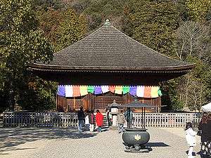
- Shiramizu Amidadō, Buddhist temple. National Treasures of Japan.
- Kurashi no Denshōgō, historical facility
- Iwaki Taira Keirin, cycle racetrack
- Kusano Simpei Memorial Hall
Festivals
- Jangara
- Iwaki Odori
- Onahama Firework Festival
- Taira Tanabata Festival
In popular media
- The 2006 film Hula Girls won five awards in 2007 Japan Academy Prize
Noted people from Iwaki
Mayors
- 1st Shōbē Akazu (赤津庄兵衛) 1966-
- 2nd Yaichi Ōwada (大和田弥一) 1966-
- 3rd Kanemitsu Tabata (田畑金光) 1974-
- 4th Takeo Nakata (中田武雄) 1986-
- 5th Mitsuhide Iwaki (岩城光英) 1990-
- 6th Keisuke Shike (四家啓助) 1997
- 7th Kazuo Kushida (櫛田一男) 2005-
Notable people
- Kusano Shimpei, poet; famous as "poet of frogs"
- Denmei Suzuki, actor
- Misaki Ito, actress
- Tadashi Suzuki, discovered Futabasaurus suzukii
- Ken-Ichiro Kobayashi, a conductor
- Takeo Takagi, Imperial Japanese Navy Admiral
- Aya Okamoto, actress
- Noboru Kousaka, a member of the House of Representatives of Japan for the Japan Socialist Party
- Rena Takeda, actress
Twinnings
Japanese sister cities
- Nobeoka, Miyazaki (since May 30, 1997); a sister city
- Yurihonjo, Akita (since August 10, 1986); a sister city. Yurihonjo City includes old Iwaki town(岩城町), who has the same name "Iwaki".
International friendship and sister cities
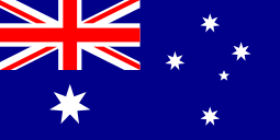 Townsville, Queensland, Australia (since August 21, 1991); a friendship city
 Fushun, Liaoning Province, China (since April 15, 1982); a sister city
References
- ↑ "Iwaki profile" (in Japanese). Official Iwaki website. Retrieved 29 July 2011.
- ↑ "Estimated population May 1, 2011" (in Japanese). Official Fukushima Prefecture website. Retrieved 29 July 2011.
- ↑ http://www.goldenjipangu.com/130806iwaki.html
- 1 2 3 4 5 6 Iwaki's history pdf
- 1 2 Imamukashi kiko of Iwaki, Kofun period - Meiji Period
- ↑ Onahama climate from the Japan Meteorological Agency
- ↑ "Onahama Climate Normals 1961-1990". National Oceanic and Atmospheric Administration. Retrieved December 30, 2012.
- ↑ Iwaki City map << Iwaki City data <<Introduction of Iwaki << English page << Iwaki city website
- ↑ Demography of Iwaki City
- ↑ Statistics of Iwaki
- ↑ TYO1 means a company quoted to the first class of Tokyo Stock Exchange(TSE). Osaka Securities Exchange(OSE), Nagoya Stock Exchange(NSE) and New York Stock Exchange(NYSE) similarly follow suit.
External links
| Wikimedia Commons has media related to Iwaki, Fukushima. |
 Iwaki travel guide from Wikivoyage
- Iwaki City official website (Japanese) (with some English pages)
- The Iwaki Minpo (evening newspaper) (Japanese)