Galien, Michigan
| Galien, Michigan | |
|---|---|
| Village | |
|
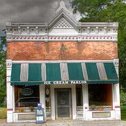
Ice Cream Parlor in Galien | |
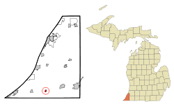 Location of Galien, Michigan | |
| Coordinates: 41°48′11″N 86°29′53″W / 41.80306°N 86.49806°W | |
| Country | United States |
| State | Michigan |
| County | Berrien |
| Area[1] | |
| • Total | 0.42 sq mi (1.09 km2) |
| • Land | 0.42 sq mi (1.09 km2) |
| • Water | 0 sq mi (0 km2) |
| Elevation | 669 ft (204 m) |
| Population (2010)[2] | |
| • Total | 549 |
| • Estimate (2012[3]) | 544 |
| • Density | 1,307.1/sq mi (504.7/km2) |
| Time zone | Eastern (EST) (UTC-5) |
| • Summer (DST) | EDT (UTC-4) |
| ZIP code | 49113 |
| Area code(s) | 269 |
| FIPS code | 26-31300[4] |
| GNIS feature ID | 1618901[5] |
Galien is a village in Berrien County in the U.S. state of Michigan. The population was 549 at the 2010 census. The village is located within Galien Township. The village provides its own sewer utility.
History
The founder of the village of Galien was George A. Blakeslee. Born in Pennsylvania, he came to Galien Township in 1853. He platted Galien village in 1861, and it was incorporated in 1879.
Blakeslee operated a sawmill at the site of present-day Galien, and established a general store. He purchased several thousand acres in the vicinity of the village and harvested the timber for his sawmill operation. For many years after Galien was established, he was president of the village.[6]
Geography
According to the United States Census Bureau, the village has a total area of 0.42 square miles (1.09 km2), all land.[1] Galien straddles U.S. Highway 12, and is located in the Galien River basin, being situated just west and south of the main stem.
Pronunciation
Residents of Galien pronounce the name of their community Guh-LEEN, not Gal-e-UN.
Demographics
| Historical population | |||
|---|---|---|---|
| Census | Pop. | %± | |
| 1880 | 413 | — | |
| 1890 | 492 | 19.1% | |
| 1900 | 440 | −10.6% | |
| 1910 | 405 | −8.0% | |
| 1920 | 460 | 13.6% | |
| 1930 | 488 | 6.1% | |
| 1940 | 567 | 16.2% | |
| 1950 | 610 | 7.6% | |
| 1960 | 750 | 23.0% | |
| 1970 | 691 | −7.9% | |
| 1980 | 692 | 0.1% | |
| 1990 | 596 | −13.9% | |
| 2000 | 593 | −0.5% | |
| 2010 | 549 | −7.4% | |
| Est. 2015 | 532 | [7] | −3.1% |
2010 census
As of the census[2] of 2010, there were 549 people, 227 households, and 133 families residing in the village. The population density was 1,307.1 inhabitants per square mile (504.7/km2). There were 255 housing units at an average density of 607.1 per square mile (234.4/km2). The racial makeup of the village was 96.4% White, 1.1% African American, 0.9% Native American, 0.2% Asian, 0.2% from other races, and 1.3% from two or more races. Hispanic or Latino of any race were 1.8% of the population.
There were 227 households of which 29.1% had children under the age of 18 living with them, 39.6% were married couples living together, 12.3% had a female householder with no husband present, 6.6% had a male householder with no wife present, and 41.4% were non-families. 33.5% of all households were made up of individuals and 16.3% had someone living alone who was 65 years of age or older. The average household size was 2.42 and the average family size was 3.09.
The median age in the village was 37.6 years. 24% of residents were under the age of 18; 8.6% were between the ages of 18 and 24; 26.3% were from 25 to 44; 25.3% were from 45 to 64; and 15.7% were 65 years of age or older. The gender makeup of the village was 50.3% male and 49.7% female.
2000 census
As of the census[4] of 2000, there were 593 people, 223 households, and 159 families residing in the village. The population density was 1,329.9 per square mile (508.8/km²). There were 244 housing units at an average density of 547.2 per square mile (209.4/km²). The racial makeup of the village was 96.96% White, 0.17% Native American, and 2.87% from two or more races. Hispanic or Latino of any race were 0.84% of the population.
There were 223 households out of which 35.9% had children under the age of 18 living with them, 46.6% were married couples living together, 20.2% had a female householder with no husband present, and 28.3% were non-families. 23.8% of all households were made up of individuals and 10.3% had someone living alone who was 65 years of age or older. The average household size was 2.63 and the average family size was 3.14.
In the village the population was spread out with 30.9% under the age of 18, 9.3% from 18 to 24, 29.0% from 25 to 44, 18.9% from 45 to 64, and 12.0% who were 65 years of age or older. The median age was 34 years. For every 100 females there were 99.7 males. For every 100 females age 18 and over, there were 88.9 males.
The median income for a household in the village was $35,250, and the median income for a family was $35,313. Males had a median income of $36,053 versus $17,692 for females. The per capita income for the village was $15,739. About 13.3% of families and 14.3% of the population were below the poverty line, including 22.0% of those under age 18 and 10.0% of those age 65 or over.
References
- 1 2 "US Gazetteer files 2010". United States Census Bureau. Retrieved 2012-11-25.
- 1 2 "American FactFinder". United States Census Bureau. Retrieved 2012-11-25.
- ↑ "Population Estimates". United States Census Bureau. Retrieved 2013-06-03.
- 1 2 "American FactFinder". United States Census Bureau. Retrieved 2008-01-31.
- ↑ "US Board on Geographic Names". United States Geological Survey. 2007-10-25. Retrieved 2008-01-31.
- ↑ Coolidge, Orville W. (1906). A Twentieth Century History of Berrien County Michigan, p. 281. The Lewis Publishing Company.
- ↑ "Annual Estimates of the Resident Population for Incorporated Places: April 1, 2010 to July 1, 2015". Retrieved July 2, 2016.
- ↑ "Census of Population and Housing". Census.gov. Retrieved June 4, 2015.
Municipalities and communities of Berrien County, Michigan, United States | ||
|---|---|---|
| Cities |  | |
| Villages | ||
| Charter townships | ||
| General law townships | ||
| CDPs | ||
| Other unincorporated communities | ||
| Footnotes | ‡This populated place also has portions in an adjacent county or counties | |
Coordinates: 41°47′53″N 86°29′57″W / 41.79806°N 86.49917°W