Watervliet Township, Michigan
| Watervliet Charter Township, Michigan | |
|---|---|
| Charter township | |
 | |
 Watervliet Charter Township Location within the state of Michigan | |
| Coordinates: 42°12′0″N 86°15′24″W / 42.20000°N 86.25667°WCoordinates: 42°12′0″N 86°15′24″W / 42.20000°N 86.25667°W | |
| Country | United States |
| State | Michigan |
| County | Berrien |
| Government | |
| • Supervisor | Dan Hutchins |
| Area | |
| • Total | 14.5 sq mi (37.5 km2) |
| • Land | 13.5 sq mi (34.9 km2) |
| • Water | 1.0 sq mi (2.6 km2) |
| Elevation | 656 ft (200 m) |
| Population (2010) | |
| • Total | 3,102 |
| • Density | 230/sq mi (88.9/km2) |
| Time zone | Eastern (UTC-5) |
| • Summer (DST) | Eastern (UTC-4) |
| ZIP code | 49098 |
| Area code(s) | 269 |
| FIPS code | 26-84520[1] |
| GNIS feature ID | 1627225[2] |
| Website |
www |
Watervliet Charter Township is a charter township of Berrien County in the U.S. state of Michigan. The population was 3,102 at the 2010 census.[3]
The township originally included the area of Coloma Charter Township, which was separated in 1917. The city of Watervliet is the only incorporated municipality in the township. The Paw Paw River and Paw Paw Lake are prominent features of the township.
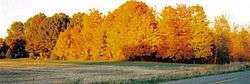
The Watervliet area is host to many "summer homes", which has contributed considerably to the local economy as well as increased development.
Interstate 94 crosses east-west through the south of the township with two interchanges, and M-140 runs north-south through the area.
Officials
| Office | Official |
|---|---|
| Supervisor | Dan Hutchins |
| Clerk | Patricia (Patt) Bambrick |
| Treasurer | Tom Scheid |
| Trustee | Vick Kinzler |
| Trustee | Joe Stepich |
| Trustee | Bob Wallace |
| Trustee | Joe Matthews |
| Deputy Clerk | Marcia VanDrasek |
| Deputy Treasurer | Linda Willer |
| Building Inspector | Thomas Baldwin |
| Mechanical Inspector | Rod Wilder |
| Electrical Inspector | Ken Simpson |
| Plumbing Inspector | Phyllis Centers |
| Director of Public Works | Robert Lohr |
| Zoning Administrator | Robert Lohr |
| Assessor | Patricia Armstrong |
| Attorney | Donald D. Dettman |
History
Watervliet Township began as a much larger block of land that included the areas now known as Watervliet Township and Coloma Township. It was a perfect location for industry, with its rolling land of timber and the flowing waters of the Paw Paw River emptying into Lake Michigan at the harbor of St. Joseph. Prior to the formation of Coloma Township in 1917, prosperous sawmills encouraged the formation of the early village of Shingle Diggings, which was followed by the birth of the cities of Coloma and Watervliet.
As timber was cleared, and the early village of Waterford (later called Watervliet) was established, farming of the newly cleared land became a lucrative business in Watervliet Township. Hard working, resourceful men turned harvested land into thriving farms. Harvey Sherwood came to the township in 1870 and became known as the "Apple King of Michigan", with one of the largest orchards in the state. His farm was called Lake View, because of its panoramic view of Sherwood Bay on Paw Paw Lake.
After his marriage in 1854, Sebastian Smith settled in Watervliet Township. As an entrepreneur, he encountered and overcame many difficulties, due to his insistent efforts. By 1878 he had established himself as one of the first major international businessmen in the area when he succeeded in shipping carloads of apples to London, England.
Over the years, Watervliet Township maintained its rural atmosphere, yet wisely encouraged businesses to locate within its borders.
Geography
According to the United States Census Bureau, Watervliet Township has a total area of 14.5 square miles (37.5 km2), of which 13.5 square miles (34.9 km2) is land and 1.0 square mile (2.6 km2), or 6.99%, is water.[3] The largest water body in the township is Paw Paw Lake, shared with Coloma Township. The census-designated place of Paw Paw Lake consists of housing developments that surround the lake and is split evenly between the two townships.
Demographics
As of the census[1] of 2000, there were 3,392 people, 1,348 households, and 939 families residing in the township. The population density was 248.7 per square mile (96.0/km²). There were 1,724 housing units at an average density of 126.4 per square mile (48.8/km²). The racial makeup of the township was 93.66% White, 1.71% African American, 0.88% Native American, 0.32% Asian, 2.27% from other races, and 1.15% from two or more races. Hispanic or Latino of any race were 4.22% of the population.
There were 1,348 households out of which 30.5% had children under the age of 18 living with them, 53.9% were married couples living together, 11.6% had a female householder with no husband present, and 30.3% were non-families. 25.8% of all households were made up of individuals and 11.4% had someone living alone who was 65 years of age or older. The average household size was 2.46 and the average family size was 2.93.
In the township the population was spread out with 25.6% under the age of 18, 8.5% from 18 to 24, 27.2% from 25 to 44, 24.5% from 45 to 64, and 14.3% who were 65 years of age or older. The median age was 37 years. For every 100 females there were 92.7 males. For every 100 females age 18 and over, there were 90.8 males.
The median income for a household in the township was $39,152, and the median income for a family was $45,709. Males had a median income of $35,842 versus $22,500 for females. The per capita income for the township was $22,134. About 7.8% of families and 10.5% of the population were below the poverty line, including 12.0% of those under age 18 and 9.6% of those age 65 or over.
References
- 1 2 "American FactFinder". United States Census Bureau. Retrieved 2008-01-31.
- ↑ U.S. Geological Survey Geographic Names Information System: Watervliet Township, Michigan
- 1 2 "Geographic Identifiers: 2010 Demographic Profile Data (G001): Watervliet township, Berrien County, Michigan". U.S. Census Bureau, American Factfinder. Retrieved January 9, 2014.
External links
- Watervliet Charter Township official website
- Watervliet Public Schools
- Tri-City Record, the local newspaper
Municipalities and communities of Berrien County, Michigan, United States | ||
|---|---|---|
| Cities | 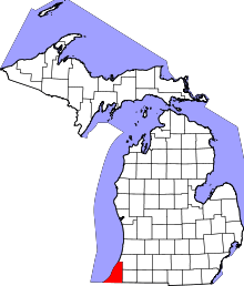 | |
| Villages | ||
| Charter townships | ||
| General law townships | ||
| CDPs | ||
| Other unincorporated communities | ||
| Footnotes | ‡This populated place also has portions in an adjacent county or counties | |