Gilboa, Ohio
| Gilboa, Ohio | |
|---|---|
| Village | |
|
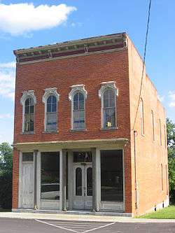
A commercial building in Gilboa's historic downtown | |
 Location of Gilboa, Ohio | |
 Location of Gilboa in Putnam County | |
| Country | United States |
| State | Ohio |
| County | Putnam |
| Government | |
| • Type | Village Council |
| • Mayor | Richard McCullough |
| • Council President | Amber Kisseberth |
| • Clerk/Treasurer | Chrissy Durst |
| Area[1] | |
| • Total | 0.15 sq mi (0.39 km2) |
| • Land | 0.15 sq mi (0.39 km2) |
| • Water | 0 sq mi (0 km2) |
| Elevation[2] | 748 ft (228 m) |
| Population (2010)[3] | |
| • Total | 184 |
| • Estimate (2012[4]) | 182 |
| • Density | 1,226.7/sq mi (473.6/km2) |
| Time zone | Eastern (EST) (UTC-5) |
| • Summer (DST) | EDT (UTC-4) |
| ZIP code | 45875 |
| Area code(s) | 419 |
| FIPS code | 39-30114[5] |
| GNIS feature ID | 1048782[2] |
| Historical population | |||
|---|---|---|---|
| Census | Pop. | %± | |
| 1850 | 378 | — | |
| 1860 | 315 | −16.7% | |
| 1870 | 315 | 0.0% | |
| 1880 | 287 | −8.9% | |
| 1890 | 264 | −8.0% | |
| 1900 | 346 | 31.1% | |
| 1910 | 345 | −0.3% | |
| 1920 | 235 | −31.9% | |
| 1930 | 201 | −14.5% | |
| 1940 | 209 | 4.0% | |
| 1950 | 181 | −13.4% | |
| 1960 | 207 | 14.4% | |
| 1970 | 212 | 2.4% | |
| 1980 | 212 | 0.0% | |
| 1990 | 208 | −1.9% | |
| 2000 | 170 | −18.3% | |
| 2010 | 184 | 8.2% | |
| Est. 2015 | 186 | [6] | 1.1% |
Gilboa is a village in Putnam County, Ohio, United States. The village is named after Mount Gilboa.[8] The population was 184 at the 2010 census.
Geography
Gilboa is located at 41°1′2″N 83°55′16″W / 41.01722°N 83.92111°W (41.017329, -83.921143).[9]
According to the United States Census Bureau, the village has a total area of 0.15 square miles (0.39 km2), all land.[1]
Demographics
2010 census
As of the census[3] of 2010, there were 184 people, 71 households, and 50 families residing in the village. The population density was 1,226.7 inhabitants per square mile (473.6/km2). There were 76 housing units at an average density of 506.7 per square mile (195.6/km2). The racial makeup of the village was 94.6% White, 0.5% Asian, 3.8% from other races, and 1.1% from two or more races. Hispanic or Latino of any race were 9.2% of the population.
There were 71 households of which 35.2% had children under the age of 18 living with them, 57.7% were married couples living together, 5.6% had a female householder with no husband present, 7.0% had a male householder with no wife present, and 29.6% were non-families. 28.2% of all households were made up of individuals and 12.7% had someone living alone who was 65 years of age or older. The average household size was 2.59 and the average family size was 3.18.
The median age in the village was 34 years. 25.5% of residents were under the age of 18; 8.7% were between the ages of 18 and 24; 24.4% were from 25 to 44; 22.3% were from 45 to 64; and 19% were 65 years of age or older. The gender makeup of the village was 49.5% male and 50.5% female.
2000 census
As of the census[5] of 2000, there were 170 people, 72 households, and 43 families residing in the village. The population density was 1,139.3 people per square mile (437.6/km2). There were 78 housing units at an average density of 522.8 per square mile (200.8/km2). The racial makeup of the village was 98.24% White, 0.59% from other races, and 1.18% from two or more races. Hispanic or Latino of any race were 0.59% of the population.
There were 72 households out of which 29.2% had children under the age of 18 living with them, 47.2% were married couples living together, 8.3% had a female householder with no husband present, and 38.9% were non-families. 33.3% of all households were made up of individuals and 12.5% had someone living alone who was 65 years of age or older. The average household size was 2.36 and the average family size was 3.05.
In the village the population was spread out with 26.5% under the age of 18, 4.1% from 18 to 24, 34.1% from 25 to 44, 20.6% from 45 to 64, and 14.7% who were 65 years of age or older. The median age was 36 years. For every 100 females there were 112.5 males. For every 100 females age 18 and over, there were 104.9 males.
The median income for a household in the village was $29,844, and the median income for a family was $31,250. Males had a median income of $29,286 versus $22,045 for females. The per capita income for the village was $15,535. None of the families and 5.2% of the population were living below the poverty line, including no under eighteens and 11.5% of those over 64.
School
Pandora-Gilboa is the school district many students from Gilboa attend, although some attend Ottawa-Glandorf.
History
Gilboa was laid out in 1837.[10] The village was incorporated in 1848.[11] A post office was established at Gilboa in 1843, and remained in operation until 1985.[12]
On August 6, 1852 a Cholera epidemic struck Gilboa. The start of the epidemic was traced to a large damp celler that had been used to store trash and decomposing waste.[13] The epidemic lasted until the August 21st and killed 13 Gilboa residents[13] including one of the two doctors that had not fled. Out of the estimated 600 population, all but 40 fled including 4 of the 6 Gilboa doctors. Once the Cholera ran its course, the population suffered from Typhoid Fever and diarrhea for the remainder of the year.
Mayors
- 1909 - D R Oren[14] Term Exp. 1910
Gilboa post masters
- 1851 - Lyman W Moe[15]
- 1855 - John E Creighton[16]
- 1857 - Jerome Youngkin[17]
- 1859 - Jerome Youngkin[18]
Notable natives
- Edward S. Matthias was an Ohio Supreme Court justice from 1914 until his death in 1953. Having served 38 years, he was the longest serving justice of the court.
- Dr Charles H. Spencer D.O. was one of the pioneers of modern Osteopathic medicine.[19][20]
Gilboa related/referencing literary works
- Fatal Depth: Deep Sea Diving, China Fever, and the wreck of the Andrea Doria Author Joseph Haberstroh - Although the author states that the Gilboa Quarry his character trains at is near Cincinnati he describes driving on Old State Route 224 and passing Gilboa's giant fiberglass bull.[21]
References
- 1 2 "US Gazetteer files 2010". United States Census Bureau. Retrieved 2013-01-06.
- 1 2 "US Board on Geographic Names". United States Geological Survey. 2007-10-25. Retrieved 2008-01-31.
- 1 2 "American FactFinder". United States Census Bureau. Retrieved 2013-01-06.
- ↑ "Population Estimates". United States Census Bureau. Retrieved 2013-06-17.
- 1 2 "American FactFinder". United States Census Bureau. Retrieved 2008-01-31.
- ↑ "Annual Estimates of the Resident Population for Incorporated Places: April 1, 2010 to July 1, 2015". Retrieved July 2, 2016.
- ↑ "Census of Population and Housing". Census.gov. Retrieved June 4, 2015.
- ↑ Gannett, Henry (1905). The Origin of Certain Place Names in the United States. Govt. Print. Off. p. 137.
- ↑ "US Gazetteer files: 2010, 2000, and 1990". United States Census Bureau. 2011-02-12. Retrieved 2011-04-23.
- ↑ Kinder, George D. (1915). History of Putnam County, Ohio : its peoples, industries, and institutions. B.F. Bowen. p. 117.
- ↑ Acts of the State of Ohio. N. Willis, printer to the state. 1848. p. 167.
- ↑ "Putnam County". Jim Forte Postal History. Retrieved 14 December 2015.
- 1 2 Transactions of the American Medical Association Volume 7. Association. 1854. p. 349.
- ↑ Ohio Township & Municipal Officers 1909, pg. 410, retrieved 2011-09-14.
- ↑ Table of Post Offices in The United States on the 1st of January, 1851, pg. 102, retrieved 2011-09-15.
- ↑ List of Post Offices in The United States on the 1st of July, 1855, pg. 61, retrieved 2011-09-14.
- ↑ List of Post Offices in The United States on the 13th of July, 1857, pg. 56, retrieved 2011-09-14.
- ↑ List of The Post Offices of The United States on the 1st of April, 1859, pg. 61, retrieved 2011-09-14.
- ↑ Osteopathic Medicine Association Distinguished Service Award, retrieved 2011-09-15.
- ↑ Los Angeles From the Mountains to the Sea, pg. 627, retrieved 2011-09-15.
- ↑ Fatal Depth, pg. 186-187, retrieved 2011-09-15.
External links
Municipalities and communities of Putnam County, Ohio, United States | ||
|---|---|---|
| Villages | 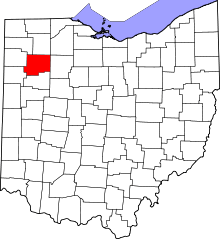 | |
| Townships | ||
| CDP | ||
| Unincorporated communities | ||
| Ghost towns | ||