Vaughnsville, Ohio
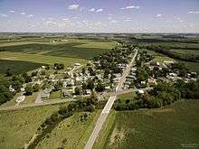
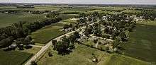

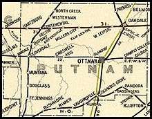
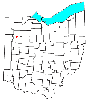
Vaughnsville (pronounced VAWNZ-vil) is an unincorporated community in southern Sugar Creek Township, Putnam County, Ohio, United States. Although it is unincorporated, it has a post office, with the ZIP code of 45893.[2] It lies along State Route 115 at its intersection with State Routes 12 and 189. Sugar Creek flows along the west and south of Vaughnsville.
History
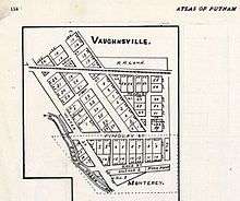
Vaughnsville was originally called Monterey, and under the latter name was laid out in 1847.[3] An addition was made by Daniel C. Vaughn, who gave the town his name.[4] A post office called Vaughnsville has been in operation since 1848.[5]
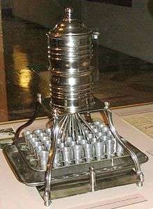
Vaughnsville's most unusual claim to fame is the first location in the World to use individual communion cups for the Lord's Supper. Though contested.[6] John G. Thomas—a physician and pastor of the Vaughnsville Congregational Church—designed a communion outfit after noticing “a communicant with a diseased mouth condition”.[7] Thomas applied for a patent for his invention on August 2, 1893, in which he wrote that he “invented certain new and useful improvements in communion service” which would “provide an individual or separate cup for the use of each person at the celebration of the Lord’s Supper, commonly called the communion service…” (Serial No. 482,186). According to The Lima News, Thomas and his church elders first experimented with the individual cups “sometime during 1893” (January 16, 1955, p. 5B). The patent for his invention was granted on March 6, 1894, and marked the first time an individual cup service received letters patent in the United States (Patent No. 516,065). Thomas moved to Lima and started the Thomas Communion Service Company in 1893 and it was sold in 1972.
For many years the Nothern Ohio Railroad maintained a passenger and freight station in Vaughnsville, and later a telegraph outlet, later Nothern Ohio Railroad was bought by the Akron, Canton and Youngstown Railroad, Trains #90/95 were known as the "Delphos Bullet", it was a mixed use train of freight and passenger that ran the entire 165 mile run from Akron to Delphos. The last run of this trip was on July 20, 1951 and was Ohio's last mixed train. The tracks were abandoned soon after and removed completely in the 80's.[8][9]
The first grist mill in the county was constructed in 1831 by Benjamin Clevenger on the east bank of Sugar Creek where Vaughnsville is today. In 1832 Clevenger made a road to Lima from Vaughnsville. Shortly after the Civil War, the first stone pike was laid in Sugar Creek township, which today is State Route 115.[10] In 1915 Vaughnsville had The Vaughnsville Banking Company, a branch of the People's Banking Company of Columbus Grove,[11] an elevator, saw-mill and a grocery store owned by Frank E. Roberts which was later known as the C & B store.[3]
Vaughnsville had a middle and high school until it was consolidated with Columbus Grove in 1962. The original school house was built in 1908 at a cost of $15,000. An addition that doubled the school capacity was made in 1915 for $11,000.[3]

The top of the school building was demolished and the gym and cafeteria still remains and is used for community events.
Geography
Soil is mostly of the Vaughnsville loam / Hoytville-Napanee type which occurs along the bases of an old glacial-lake beaches southwest of Vaughnsville, northeast of Pandora, and southeast of Leipsic. It warms up early in the spring and easy to manage.This type of soil is neutral to slightly acid and run-off is slow to moderate. This type of soil is prime farmland if drained, commonly used with corn, soybeans, and small grain.[12][13][14][15]
The USDA Plant Hardiness gives Vaughnsville a Zone 6a -10 to -5 (F) [16] The predominant tree species is Ash, Hickory, Sugar Maple, Northern Red Oak and Red Maple.[17]
The bedrock is Silurian, primary rock type is Dolostone with Shale being the secondary rock type.[18]
Topography
Vaughnsville lies at 761 feet / 232 meters above sea level with flat terrain.[19]
Climate
Vaughnsville has a humid continental climate, classified as Dfa by the Köppen-Geiger system with cool to cold winters and humid hot summers, this climate type only exists in the Northern Hemisphere.
Vaughnsville average rainfall is 35 inches / 886 m and the average temperature is 49.6 °F / 9.8 °C per year. Vaughnsville has had an average annual snowfall of 13.8 inches over the last 30 years.[20] On average, there are 180 sunny days per year and any measurable precipitation is 114 days in Vaughnsville, Ohio. The July high is around 84 degrees. The January low is 18.[21] The record rainfall for one day in Vaughnsville is 8.14 inches on August 19, 2007.[22] All time high was 109.04 °F on July 14, 1936 with the all time low -23.08 °F on February 26, 1963.[23]
Record Highs By Month [24]
| Month | Record High | Record High Date |
|---|---|---|
| January | 77.0° | January 21, 1906 |
| February | 73.0° | February 25, 2000 |
| March | 86.0° | March 21, 2012 |
| April | 90.0° | April 29, 1899 |
| May | 96.1° | May 17, 1962 |
| June | 102.9° | June 25, 1988 |
| July | 109.0° | July 14, 1936 |
| August | 104.0° | August 27, 1948 |
| September | 100.9° | September 15, 1939 |
| October | 93.0° | October 3, 1898 |
| November | 79.0° | November 1, 1933 |
| December | 71.1° | December 2, 1982 |
Record Lows By Month
| Month | Record Low | Record Low Date |
|---|---|---|
| January | -20.9° | January 19, 1994 |
| February | -23.1° | February 26, 1963 |
| March | -13.0° | March 9, 1984 |
| April | 6.1° | April 7, 1982 |
| May | 25.0° | May 7, 1974 |
| June | 36.0° | June 2, 1910 |
| July | 41.0° | July 10, 1898 |
| August | 36.0° | August 29, 1965 |
| September | 24.1° | September 29, 1893 |
| October | 15.1° | October 30, 1895 |
| November | -2.9° | November 30, 1958 |
| December | -18.9° | December 22, 1989 |
Monthly Averages & Records 1981-2010
| Date | Average
Low |
Average
High |
Average
Precipitation |
Average
Snow |
| January | 18° | 33° | 2.22" | 3.7" |
| February | 22° | 37° | 1.98" | 4" |
| March | 30° | 48° | 2.68" | 1.4" |
| April | 39° | 60° | 3.46" | 0.8" |
| May | 50° | 72° | 3.89" | NA |
| June | 59° | 80° | 4.05" | NA |
| July | 63° | 84° | 4.26" | NA |
| August | 62° | 81° | 3.38" | NA |
| September | 55° | 76° | 3.07" | NA |
| October | 44° | 64° | 2.41" | 0.1" |
| November | 34° | 50° | 3.12" | 0.6" |
| December | 24° | 38° | 2.68" | 3.2" |
Record Daily Precipitation Records
| Date | Maximum Precipitation |
|---|---|
| August 19, 2007 | 8.14 in. |
| August 21, 2007 | 6.19 in. |
| July 8, 1997 | 4.91 in. |
| August 16, 1997 | 4.85 in. |
| June 14, 1981 | 4.16 in. |
Severe Weather
Vaughnsville is covered by the National Weather Service in Northern Indiana (IWX) and Wilmington, Ohio (ILN) with radar from KIWX North Webster. The nearest weather station is at Lima Allen County Airport (KAOH).[25]
A Derecho took place on June 29, 2012. An intense line of thunderstorms or Derecho developed over northern Indiana during the middle of the afternoon and then raced southeast across the central portion of Ohio. Widespread damage was reported from Findlay to Marion to Mount Vernon, with many trees and some barns damaged around Vaughnsville.[26]
No tornados have hit Vaughnsville in known records. The nearest has been a EF0 tornado to the southwest on June 8, 1993 2:30 pm.[27]
Demographics
According to the 2010 census, the population is 262 people.[28] Females outnumber males 133 to 129. The median age for males is 32 and females is 38. The number of Occupied Homes is 104.[29]
| Racial Composition | 2010 |
|---|---|
| White Alone | 253 / 95.56% |
| Two Or More Races | 1 / 0.38% |
| Asian Alone | 3 / 1.15% |
| Hispanic | 5 / 1.191% |
Telephone and Internet Access
Telephone service and Internet Access is provided by Vaughnsville Communication, a subscriber-owned cooperative.[30] It has the distinction of being the smallest community-based telephone company in the state of Ohio.[31] Telephone area codes for Vaughnsville are (419) & (567).
References
- ↑ "Putnam County Ohio Railroad Stations". www.west2k.com. Retrieved 2016-10-24.
- ↑ Zip Code Lookup
- 1 2 3 Kinder, George D. (1915). History of Putnam County, Ohio : its peoples, industries, and institutions. B.F. Bowen. p. 158.
- ↑ Warren, Robert (May 31, 1953). "Blanchard River Brought Pioneers To Putnam". Toledo Blade. p. 3. Retrieved 30 April 2015.
- ↑ "Putnam County". Jim Forte Postal History. Retrieved 30 April 2015.
- ↑ "Who First Adopted Individual Cups as a Regular Communion Practice? | SharperIron". sharperiron.org. Retrieved 2016-11-21.
- ↑ Rusler, William; American Historical Society (New York) (1921-01-01). A standard history of Allen county, Ohio : an authentic narrative of the past, with particular attention to the modern era in the commercial, industrial, educational, civic and social development. Chicago ; New York : The American Historical Society.
- ↑ "ACY: when was it abandoned?". Trainorders.com Discussion. Retrieved 2016-10-25.
- ↑ Sanders, Craig (2007-01-17). Akron Railroads (1st edition ed.). Charleston, SC: Arcadia Publishing. ISBN 9780738541419.
- ↑ Carroll, Audrey (1973). Centennial History 1873-1973. Putnam County Pioneer Association. pp. 122–123.
- ↑ Kinder, George D. (1915). History of Putnam County, Ohio Its Peoples, Industries, and Institutions, 1915. Indianapolis, Ind. : B.F. Bowen, 1915. p. 206.
- ↑ "Soil survey. OH: Putnam Co. 1930.". HathiTrust. Retrieved 2016-10-25.
- ↑ "Official Series Description - VAUGHNSVILLE Series". soilseries.sc.egov.usda.gov. Retrieved 2016-10-25.
- ↑ Soil Survey, Putnam County, Ohio. Soil Conservation Service. 1974-01-01.
- ↑ "SoilWeb: An Online Soil Survey Browser | California Soil Resource Lab". casoilresource.lawr.ucdavis.edu. Retrieved 2016-10-25.
- ↑ "USDA Plant Hardiness Zone Map". planthardiness.ars.usda.gov. Retrieved 2016-10-24.
- ↑ "Ohio's Forest 2011" (PDF). http://www.nrs.fs.fed.us/. External link in
|website=(help) - ↑ Program, Mineral Resources. "Ohio geology". mrdata.usgs.gov. Retrieved 2016-10-24.
- ↑ "GNIS Detail - Vaughnsville". geonames.usgs.gov. Retrieved 2016-10-24.
- ↑ "Vaughnsville, Ohio". snowfall.weatherdb.com. Retrieved 2016-10-25.
- ↑ "Vaughnsville, Ohio Climate". www.bestplaces.net. Retrieved 2016-10-25.
- ↑ "What is the record rainfall in Vaughnsville, Ohio?". rainfall.weatherdb.com. Retrieved 2016-10-25.
- ↑ "Vaughnsville, Ohio". temperature.weatherdb.com. Retrieved 2016-10-25.
- ↑ "Putnam County, OH - 10/13/2016". daily-weather.weatherdb.com. Retrieved 2016-10-25.
- ↑ Service, US Department of Commerce, NOAA, National Weather. "National Weather Service". forecast.weather.gov. Retrieved 2016-10-24.
- ↑ Service, US Department of Commerce, NOAA, National Weather. "2012 Notable Weather Events". www.weather.gov. Retrieved 2016-10-24.
- ↑ "Tornado History Project: Putnam County, Ohio". www.tornadohistoryproject.com. Retrieved 2016-10-24.
- ↑ "2010 Census Population of Vaughnsville, Ohio - CensusViewer". censusviewer.com. Retrieved 2016-10-24.
- ↑ suburbanstats.org. "Current Vaughnsville, Ohio Population, Demographics and stats in 2016, 2015.". SuburbanStats.org. Retrieved 2016-10-24.
- ↑ Vaughnsville Communication
- ↑ "Vaughnsville Telephone Company - New Paradigm Resources Group, Inc.". www.nprg.com. Retrieved 2016-10-24.
Municipalities and communities of Putnam County, Ohio, United States | ||
|---|---|---|
| Villages | 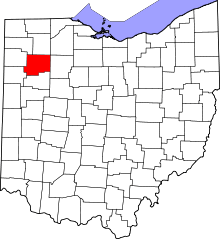 | |
| Townships | ||
| CDP | ||
| Unincorporated communities | ||
| Ghost towns | ||
Coordinates: 40°52′54″N 84°09′02″W / 40.88167°N 84.15056°W