Glendale, Wisconsin
| Glendale, Wisconsin | |
|---|---|
| City | |
| Motto: Rich Past, Bright Future | |
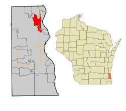 Location of Glendale, Wisconsin | |
| Coordinates: 43°7′48″N 87°55′40″W / 43.13000°N 87.92778°WCoordinates: 43°7′48″N 87°55′40″W / 43.13000°N 87.92778°W | |
| Country | United States |
| State | Wisconsin |
| County | Milwaukee |
| Area[1] | |
| • Total | 5.97 sq mi (15.46 km2) |
| • Land | 5.76 sq mi (14.92 km2) |
| • Water | 0.21 sq mi (0.54 km2) |
| Elevation[2] | 653 ft (199 m) |
| Population (2010)[3] | |
| • Total | 12,872 |
| • Estimate (2012[4]) | 12,932 |
| • Density | 2,234.7/sq mi (862.8/km2) |
| Time zone | Central (CST) (UTC-6) |
| • Summer (DST) | CDT (UTC-5) |
| Area code(s) | 414 |
| FIPS code | 55-29400[5] |
| GNIS feature ID | 1565570[2] |
| Website | www.glendale-wi.org |
Glendale is a city in Milwaukee County, Wisconsin, United States. The population was 12,872 at the 2010 census.
Geography
Glendale is located at 43°7′48″N 87°55′40″W / 43.13000°N 87.92778°W (43.130060, -87.927719).[6]
According to the United States Census Bureau, the city has a total area of 5.97 square miles (15.46 km2), of which, 5.76 square miles (14.92 km2) is land and 0.21 square miles (0.54 km2) is water.[1]
History
Glendale was incorporated on December 28, 1950 from portions of the Town of Milwaukee.[7] It began to develop rapidly in the 1950s, reflecting post-World War II metropolitan growth and migration patterns throughout the United States. Bayshore Town Center (formerly called Bayshore Mall) was established on the eastern border of the city in 1954.
Unlike other northshore suburbs of Milwaukee, Glendale has a mix of industry and commercial sites in addition to residential areas. The southern areas of the city have mainly industrial and higher density residential sites, while the north features medium to lower density residential plots. Interstate 43 divides the city into east and west sections. Nicolet High School is also located in Glendale and serves the city, along with the suburbs of Fox Point, Bayside, and River Hills. Glendale has begun an ambitious campaign to attract business and population growth. Major roads have undergone massive streetscaping projects, Bayshore Town Center has undergone a multimillion-dollar renovation, and the Glendale Business Park continues to welcome high tech clients.
Demographics
| Historical population | |||
|---|---|---|---|
| Census | Pop. | %± | |
| 1960 | 9,537 | — | |
| 1970 | 13,426 | 40.8% | |
| 1980 | 13,882 | 3.4% | |
| 1990 | 14,088 | 1.5% | |
| 2000 | 13,367 | −5.1% | |
| 2010 | 12,872 | −3.7% | |
| Est. 2015 | 12,870 | [8] | 0.0% |
2010 census
As of the census[3] of 2010, there were 12,872 people, 5,815 households, and 3,381 families residing in the city. The population density was 2,234.7 inhabitants per square mile (862.8/km2). There were 6,191 housing units at an average density of 1,074.8 per square mile (415.0/km2). The racial makeup of the city was 79.4% White, 14.1% African American, 0.2% Native American, 3.2% Asian, 0.1% Pacific Islander, 0.7% from other races, and 2.3% from two or more races. Hispanic or Latino of any race were 3.6% of the population.
There were 5,815 households of which 23.3% had children under the age of 18 living with them, 46.1% were married couples living together, 9.2% had a female householder with no husband present, 2.8% had a male householder with no wife present, and 41.9% were non-families. 35.6% of all households were made up of individuals and 16.6% had someone living alone who was 65 years of age or older. The average household size was 2.14 and the average family size was 2.80.
The median age in the city was 46.8 years. 18.7% of residents were under the age of 18; 6.9% were between the ages of 18 and 24; 22.2% were from 25 to 44; 29.8% were from 45 to 64; and 22.6% were 65 years of age or older. The gender makeup of the city was 46.4% male and 53.6% female.
2000 census
As of the census[5] of 2000, there were 13,367 people, 5,772 households, and 3,515 families residing in the city. The population density was 2,307.4 people per square mile (891.4/km²). There were 5,974 housing units at an average density of 1,031.2 per square mile (398.4/km²). The racial makeup of the city was 86.76% White, 8.13% African American, 0.23% Native American, 2.96% Asian, 0.10% Pacific Islander, 0.49% from other races, and 1.33% from two or more races. Hispanic or Latino of any race were 1.77% of the population.
There were 5,772 households out of which 24.3% had children under the age of 18 living with them, 50.0% were married couples living together, 8.2% had a female householder with no husband present, and 39.1% were non-families. 33.6% of all households were made up of individuals and 16.2% had someone living alone who was 65 years of age or older. The average household size was 2.20 and the average family size was 2.84.
In the city the population was spread out with 19.4% under the age of 18, 5.4% from 18 to 24, 24.2% from 25 to 44, 26.3% from 45 to 64, and 24.8% who were 65 years of age or older. The median age was 46 years. For every 100 females there were 86.7 males. For every 100 females age 18 and over, there were 82.4 males.
The median income for a household in the city was $55,306, and the median income for a family was $68,429. Males had a median income of $45,670 versus $36,334 for females. The per capita income for the city was $30,328. About 2.6% of families and 4.0% of the population were below the poverty line, including 3.2% of those under age 18 and 6.3% of those age 65 or over.
Economy
Education
References
- 1 2 "US Gazetteer files 2010". United States Census Bureau. Archived from the original on January 24, 2012. Retrieved 2012-11-18.
- 1 2 "US Board on Geographic Names". United States Geological Survey. 2007-10-25. Retrieved 2008-01-31.
- 1 2 "American FactFinder". United States Census Bureau. Retrieved 2012-11-18.
- ↑ "Population Estimates". United States Census Bureau. Archived from the original on June 17, 2013. Retrieved 2013-06-24.
- 1 2 "American FactFinder". United States Census Bureau. Retrieved 2008-01-31.
- ↑ "US Gazetteer files: 2010, 2000, and 1990". United States Census Bureau. 2011-02-12. Retrieved 2011-04-23.
- ↑ http://sos.nmtvault.com/pdf/THEOSOS_042/images/00020939.pdf
- ↑ "Annual Estimates of the Resident Population for Incorporated Places: April 1, 2010 to July 1, 2015". Retrieved July 2, 2016.
- ↑ "Census of Population and Housing". Census.gov. Archived from the original on May 11, 2015. Retrieved June 4, 2015.
External links
Municipalities and communities of Milwaukee County, Wisconsin, United States | ||
|---|---|---|
| Cities | 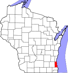 | |
| Villages | ||
| Ghost towns/ neighborhoods | ||
| Indian reservation | ||
| Footnotes | ‡This populated place also has portions in another county or counties | |
| Central city |  | |
|---|---|---|
| Largest municipalities (over 25,000 in 2010) | ||
| Municipalities (over 10,000 in 2010) | ||
| Smaller municipalities (under 10,000 in 2010) | ||
| Counties | ||