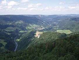
Goumois, Doubs
| Goumois | ||
|---|---|---|
 | ||
| ||
 Goumois | ||
|
Location within Bourgogne-Franche-Comté region  Goumois | ||
| Coordinates: 47°15′42″N 6°57′00″E / 47.2617°N 6.95°ECoordinates: 47°15′42″N 6°57′00″E / 47.2617°N 6.95°E | ||
| Country | France | |
| Region | Bourgogne-Franche-Comté | |
| Department | Doubs | |
| Arrondissement | Montbéliard | |
| Canton | Maîche | |
| Government | ||
| • Mayor (2008–2014) | Patrick Loriau | |
| Area1 | 5.83 km2 (2.25 sq mi) | |
| Population (2012)2 | 176 | |
| • Density | 30/km2 (78/sq mi) | |
| Time zone | CET (UTC+1) | |
| • Summer (DST) | CEST (UTC+2) | |
| INSEE/Postal code | 25280 / 25470 | |
| Elevation | 485–953 m (1,591–3,127 ft) | |
|
1 French Land Register data, which excludes lakes, ponds, glaciers > 1 km² (0.386 sq mi or 247 acres) and river estuaries. 2 Population without double counting: residents of multiple communes (e.g., students and military personnel) only counted once. | ||

Goumois is a commune in the Doubs department in the Bourgogne-Franche-Comté region in eastern France.
Population
| Historical population | ||
|---|---|---|
| Year | Pop. | ±% |
| 1962 | 142 | — |
| 1968 | 148 | +4.2% |
| 1975 | 134 | −9.5% |
| 1982 | 126 | −6.0% |
| 1990 | 136 | +7.9% |
| 1999 | 196 | +44.1% |
| 2008 | 187 | −4.6% |
| 2012 | 176 | −5.9% |
See also
References
| Wikimedia Commons has media related to Goumois (Doubs). |
This article is issued from Wikipedia - version of the 10/29/2016. The text is available under the Creative Commons Attribution/Share Alike but additional terms may apply for the media files.