Romain, Doubs
| Romain | |
|---|---|
 | |
 Romain | |
|
Location within Bourgogne-Franche-Comté region  Romain | |
| Coordinates: 47°26′37″N 6°22′30″E / 47.4436°N 6.375°ECoordinates: 47°26′37″N 6°22′30″E / 47.4436°N 6.375°E | |
| Country | France |
| Region | Bourgogne-Franche-Comté |
| Department | Doubs |
| Arrondissement | Besançon |
| Canton | Rougemont |
| Intercommunality | Pays de Rougemont |
| Government | |
| • Mayor (2008–2014) | Jean-Luc Boudeau |
| Area1 | 4.85 km2 (1.87 sq mi) |
| Population (2012)2 | 115 |
| • Density | 24/km2 (61/sq mi) |
| Time zone | CET (UTC+1) |
| • Summer (DST) | CEST (UTC+2) |
| INSEE/Postal code | 25499 / 25680 |
| Elevation | 294–458 m (965–1,503 ft) |
|
1 French Land Register data, which excludes lakes, ponds, glaciers > 1 km² (0.386 sq mi or 247 acres) and river estuaries. 2 Population without double counting: residents of multiple communes (e.g., students and military personnel) only counted once. | |
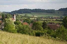
Romain (also Romain-la-Roche) is a commune in the Doubs department in the Bourgogne-Franche-Comté region in eastern France.
Geography
Romain lies 6 km (3.7 mi) south of Rougemont on a plateau near the valley of the Doubs River and the Ognon.
The Crotot cave has large galleries and stalactites.
History
The commune was known as Romain-la-Roche until 1918.
Population
| Historical population | ||
|---|---|---|
| Year | Pop. | ±% |
| 1962 | 74 | — |
| 1968 | 75 | +1.4% |
| 1975 | 59 | −21.3% |
| 1982 | 69 | +16.9% |
| 1990 | 93 | +34.8% |
| 1999 | 99 | +6.5% |
| 2008 | 102 | +3.0% |
| 2012 | 115 | +12.7% |
See also
References
External links
| Wikimedia Commons has media related to Romain (Doubs). |
- Romain on the regional Web site (French)
This article is issued from Wikipedia - version of the 10/29/2016. The text is available under the Creative Commons Attribution/Share Alike but additional terms may apply for the media files.