Grade I listed buildings in Derbyshire
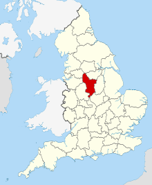
Derbyshire shown in England
There are over 9000 Grade I listed buildings in England. This page is a list of these buildings in the county of Derbyshire, sub-divided by district.
Amber Valley


Bolsover


Chesterfield
| Name | Location | Type | Completed [note 1] | Date designated | Grid ref.[note 2] Geo-coordinates |
Entry number [note 3] | Image |
|---|---|---|---|---|---|---|---|
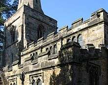
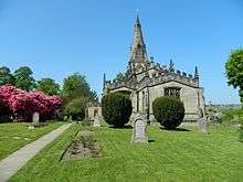
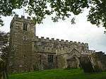
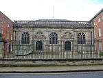
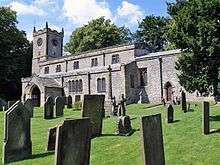
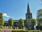
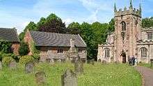
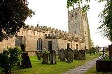
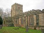
| Church of St Mary and All Saints | Chesterfield | Parish church | Medieval | 15 July 1971 | SK3851371171 53°14′10″N 1°25′28″W / 53.236181°N 1.424443°W |
1334708 | 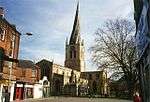 |
City of Derby


Derbyshire Dales


.jpg)


Erewash


High Peak
| Name | Location | Type | Completed [note 1] | Date designated | Grid ref.[note 2] Geo-coordinates |
Entry number [note 3] | Image |
|---|---|---|---|---|---|---|---|
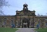
| The Crescent | Buxton | Townhouse | 1780–88 | 25 January 1951 | SK0580673572 53°15′33″N 1°54′52″W / 53.259121°N 1.914426°W |
1257876 | 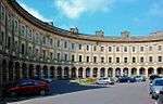 |
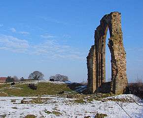
| Peveril Castle curtain walls and fragmentary foundations | Castleton | Castle | Late 11th century | 17 April 1985 | SK1493382606 53°20′25″N 1°46′38″W / 53.340148°N 1.777188°W |
1250966 | 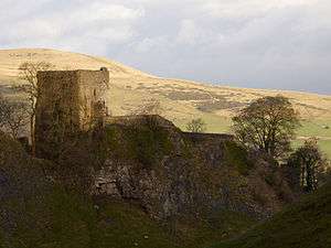 |
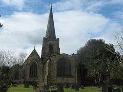
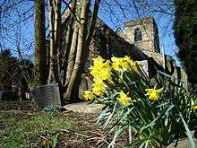
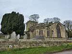
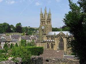
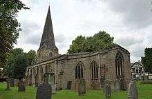
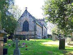
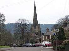
| Church of St Peter | Hope | Parish church | Early 14th century | 21 April 1967 | SK1722983470 53°20′52″N 1°44′34″W / 53.347845°N 1.742659°W |
1121945 |  |
North East Derbyshire


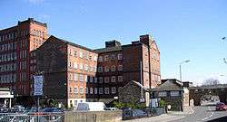
_-_geograph.org.uk_-_343396.jpg)

South Derbyshire
| Name | Location | Type | Completed [note 1] | Date designated | Grid ref.[note 2] Geo-coordinates |
Entry number [note 3] | Image |
|---|---|---|---|---|---|---|---|
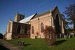
| Church of All Saints | Aston-on-Trent | Parish church | 12th century | 10 November 1967 | SK4148929348 52°51′36″N 1°23′07″W / 52.860029°N 1.385229°W |
1281625 |  |
| Church of St Wilfrid | Barrow-upon-Trent | Parish church | Mid-13th century | 10 November 1967 | SK3529328385 52°51′07″N 1°28′38″W / 52.851813°N 1.477354°W |
1096559 | 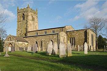 |
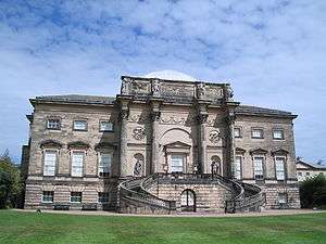
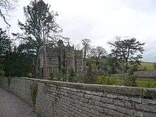
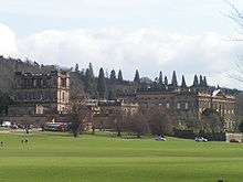
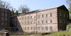
| Calke Abbey | Calke Park, Calke | Country house | 18th century | 2 September 1952 | SK3677322593 52°47′59″N 1°27′22″W / 52.79965°N 1.456028°W |
1031839 | 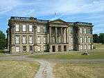 |
| Church of St Michael and All Angels | Church Broughton | Parish church | 12th century | 19 January 1967 | SK2053333767 52°54′03″N 1°41′46″W / 52.900955°N 1.696193°W |
1205179 |  |
| Church of St Wilfrid | Egginton | Church | 1690 | 19 January 1967 | SK2675527849 52°50′51″N 1°36′15″W / 52.847485°N 1.604181°W |
1334567 | 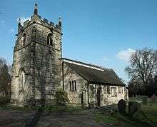 |
| Church of St Bartholomew | Elvaston | Parish church | 13th century | 10 November 1967 | SK4070432975 52°53′34″N 1°23′47″W / 52.892691°N 1.396435°W |
1096395 |  |
| Church of St Helen | Etwall | Parish church | Late 12th century | 19 January 1967 | SK2688831991 52°53′05″N 1°36′07″W / 52.884711°N 1.601865°W |
1096573 |  |
| Church of St Saviour | Foremark | Parish church | 1662 | 19 January 1967 | SK3297526472 52°50′05″N 1°30′43″W / 52.834763°N 1.511967°W |
1045861 |  |
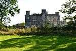
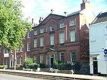
| Foremarke Hall | Foremark | Country house | Early 18th century | 2 September 1952 | SK3328526512 52°50′06″N 1°30′27″W / 52.835104°N 1.507362°W |
1096531 |  |
| Church of St Mary | Marston on Dove | Parish church | 13th century | 19 January 1967 | SK2331429633 52°51′49″N 1°39′19″W / 52.863681°N 1.655145°W |
1334544 | 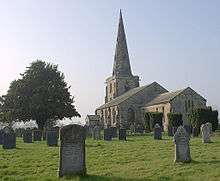 |
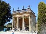
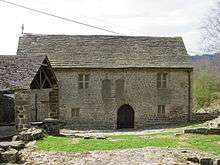
| Aisled barn attached to north of stables at Melbourne Hall | Melbourne | Barn | Early 18th century | 18 February 1971 | SK3893625052 52°49′18″N 1°25′25″W / 52.821602°N 1.423657°W |
1281386 | 
|
| Church of St Michael and St Mary | Melbourne | Parish church | c.1133–early 13th century | 10 November 1967 | SK3890024994 52°49′16″N 1°25′27″W / 52.821083°N 1.424198°W |
1204556 | 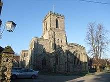 |
| Covered seat to east of Fountain Pond in Melbourne Hall gardens | Melbourne | Garden seat | c.1704 | 10 November 1967 | SK3923624854 52°49′11″N 1°25′09″W / 52.819801°N 1.419229°W |
1096377 |
|
| Covered seat to west of fountain pond in Melbourne Hall gardens | Melbourne | Garden seat | c.1704 | 10 November 1967 | SK3912624888 52°49′12″N 1°25′15″W / 52.820114°N 1.420857°W |
1262770 |
|
| Five flights of steps between terraces at Melbourne Hall gardens | Melbourne | Steps | c.1704 | 10 November 1967 | SK3908024992 52°49′16″N 1°25′17″W / 52.821052°N 1.421527°W |
1096411 |
|
| Garden walls attached to south front of Melbourne Hall with attached railings and wall to east | Melbourne | Garden wall | Late 17th century | 10 November 1967 | SK3895624974 52°49′15″N 1°25′24″W / 52.8209°N 1.423369°W |
1334648 |  |
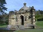
| Muniment Room in Melbourne Hall gardens | Melbourne | Pavilion | Early 17th century | 10 November 1967 | SK3901625044 52°49′17″N 1°25′21″W / 52.821525°N 1.42247°W |
1281353 |
|
| Pair of cherubs to north of statue of Mercury in Melbourne Hall gardens | Melbourne | Statue | c.1700 | 10 November 1967 | SK3911525034 52°49′17″N 1°25′16″W / 52.821427°N 1.421003°W |
1334595 |
|
| Pair of cherubs to south of statue of Mercury in Melbourne Hall gardens | Melbourne | Statue | c.1700 | 10 November 1967 | SK3911424946 52°49′14″N 1°25′16″W / 52.820637°N 1.421028°W |
1096412 |
|
| Pair of pedestals supporting fruit bowl vase in Melbourne Hall gardens | Melbourne | Vase | Late 17th century | 10 November 1967 | SK3899825013 52°49′16″N 1°25′22″W / 52.821247°N 1.422741°W |
1096409 |
|
| Pair of pedestals with lead slaves in Melbourne Hall gardens | Melbourne | Statue | c.1700 | 10 November 1967 | SK3904325010 52°49′16″N 1°25′19″W / 52.821217°N 1.422074°W |
1334634 |
|
| Pedestal and four seasons vase in Melbourne Hall gardens | Melbourne | Vase | 1705 | 10 November 1967 | SK3915124785 52°49′09″N 1°25′14″W / 52.819187°N 1.420498°W |
1281182 | .jpg) |
| Pedestal with statue of Andromeda in Melbourne Hall gardens | Melbourne | Statue | c.1700 | 10 November 1967 | SK3918725027 52°49′17″N 1°25′12″W / 52.821359°N 1.419935°W |
1334616 | .jpg) |
| Pedestal with statue of Mercury in Melbourne Hall gardens | Melbourne | Statue | c.1700 | 10 November 1967 | SK3911624990 52°49′16″N 1°25′16″W / 52.821032°N 1.420993°W |
1204240 |
|
| Pedestal with statue of Perseus in Melbourne Hall gardens | Melbourne | Statue | c.1700 | 10 November 1967 | SK3918524950 52°49′14″N 1°25′12″W / 52.820667°N 1.419974°W |
1096374 |
|
| Pedestal with vase to south-west of Fountain Pond in Melbourne Hall garden | Melbourne | Vase | Early 18th century | 10 November 1967 | SK3918824853 52°49′11″N 1°25′12″W / 52.819795°N 1.419941°W |
1096378 |
|
| Stone fountain to north of lower terrace in Melbourne Hall gardens | Melbourne | Fountain | c.1704 | 10 November 1967 | SK3911625042 52°49′17″N 1°25′16″W / 52.821499°N 1.420987°W |
1204272 |
|
| Stone fountain to south of lower terrace in Melbourne Hall gardens | Melbourne | Fountain | c.1704 | 10 November 1967 | SK3911424937 52°49′14″N 1°25′16″W / 52.820556°N 1.421029°W |
1204317 |
|
| Tea rooms to north of Melbourne Hall and attached walls | Melbourne | Country house | Early 18th century | 10 November 1967 | SK3899625066 52°49′18″N 1°25′22″W / 52.821724°N 1.422765°W |
1334633 |
|
| The Birdcage Arbour in Melbourne Hall gardens | Melbourne | Summerhouse | c.1705–10 | 10 November 1967 | SK3921924988 52°49′16″N 1°25′10″W / 52.821006°N 1.419465°W |
1096375 | 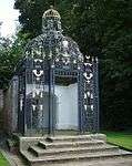 |
| Three pairs of vases flanking central path of upper terrace in Melbourne Hall gardens | Melbourne | Vase | Early 18th century | 11 March 1987 | SK3903224995 52°49′16″N 1°25′20″W / 52.821083°N 1.422239°W |
1204146 |
|
| Two pairs of cherubs to north-west of the Grand Basin in Melbourne Hall gardens | Melbourne | Statue | c.1700 | 10 November 1967 | SK3914125032 52°49′17″N 1°25′14″W / 52.821408°N 1.420617°W |
1096372 |
|
| Two pairs of cherubs to south-west of the Grand Basin in Melbourne Hall gardens | Melbourne | Statue | c.1700 | 10 November 1967 | SK3914424944 52°49′14″N 1°25′14″W / 52.820616°N 1.420583°W |
1334615 |
|
| Vase and pedestal to north-west of the Four Seasons Vase in Melbourne Hall gardens | Melbourne | Vase | Late 18th century | 10 November 1967 | SK3913624812 52°49′10″N 1°25′15″W / 52.81943°N 1.420717°W |
1096380 |
|
| Church of St Andrew | Radbourne | Parish church | 13th century | 19 January 1967 | SK2860135993 52°55′14″N 1°34′34″W / 52.920597°N 1.576059°W |
1204062 |  |
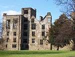
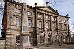
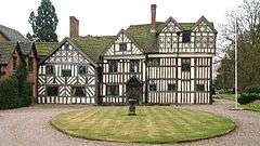
| Radbourne Hall | Radbourne | House | c.1865 | 2 September 1952 | SK2866435654 52°55′03″N 1°34′31″W / 52.917547°N 1.575152°W |
1334517 | 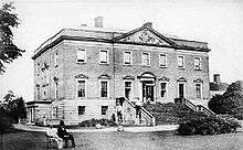 |
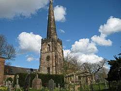
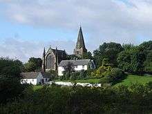
| Church of St Wystan | Repton | Parish church | 9th century | 19 January 1967 | SK3030127154 52°50′28″N 1°33′06″W / 52.84105°N 1.551595°W |
1334560 | 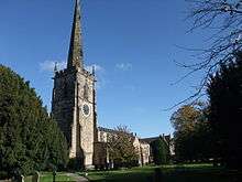 |
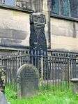
| Market Cross | Repton | Market cross | Medieval | 2 September 1952 | SK3037227016 52°50′23″N 1°33′02″W / 52.839806°N 1.550554°W |
1096537 |  |
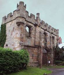
| Priory Gateway, precinct walls, the tithe barn and the Lodge, Repton School | Repton | Gate | 13th century | 19 January 1967 | SK3034827110 52°50′26″N 1°33′03″W / 52.840652°N 1.550901°W |
1055800 | 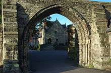 |
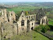
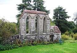
| Remains of Priory Church and the Chapter Block, Repton School | Repton | Church remains | 13th century | 19 January 1967 | SK3037827186 52°50′29″N 1°33′02″W / 52.841333°N 1.550449°W |
1096512 |
|
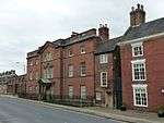
| Repton Hall with Prior Overton's Tower, Repton School | Repton | House | c.1680 | 2 September 1952 | SK3031527254 52°50′31″N 1°33′05″W / 52.841948°N 1.551378°W |
1057669 |
|
| The Old Priory, attached walls and gate piers, Repton School | Repton | Former priory | Late 12th century | 2 September 1952 | SK3033827191 52°50′29″N 1°33′04″W / 52.841381°N 1.551042°W |
1055755 | |
| Church of St James | Smisby | Parish church | 13th century | 19 January 1967 | SK3479619130 52°46′07″N 1°29′09″W / 52.768651°N 1.485717°W |
1096467 | 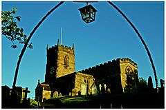 |
| Church of St Michael | Stanton by Bridge | Parish church | 11th century | 10 November 1967 | SK3673527150 52°50′26″N 1°27′22″W / 52.840615°N 1.456081°W |
1088339 | 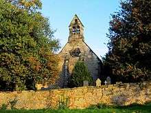 |
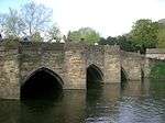
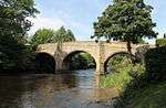
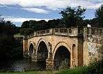
| Swarkestone Bridge and Causeway | Stanton by Bridge | Bridge | Late 13th or early 14th century | 10 November 1967 | SK3703027810 52°50′48″N 1°27′06″W / 52.846528°N 1.451627°W |
1088337 |  |
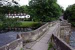
| The Grandstand, Cuttle and Gate 200 metres north of Swarkestone Hall | Swarkestone | Pavilion | c.1630 | 10 November 1967 | SK3748428614 52°51′13″N 1°26′41″W / 52.853724°N 1.444794°W |
1088345 |  |
| Church of St Andrew | Twyford and Stenson | Parish church | 12th century | 19 January 1967 | SK3274128551 52°51′12″N 1°30′55″W / 52.853466°N 1.515233°W |
1039117 |  |
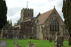
| Church of St Mary | Weston-on-Trent | Parish church | 13th century | 10 November 1967 | SK3976527597 52°50′40″N 1°24′40″W / 52.844419°N 1.411046°W |
1205737 | 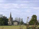 |
Notes
- 1 2 3 4 5 6 7 8 9 The date given is the date used by Historic England as significant for the initial building or that of an important part in the structure's description.
- 1 2 3 4 5 6 7 8 9 Sometimes known as OSGB36, the grid reference is based on the British national grid reference system used by the Ordnance Survey.
- 1 2 3 4 5 6 7 8 9 The "List Entry Number" is a unique number assigned to each listed building and scheduled monument by Historic England.
See also
- Category:Grade I listed buildings in Derbyshire
- Grade II* listed buildings in Amber Valley
- Grade II* listed buildings in Bolsover (district)
- Grade II* listed buildings in Chesterfield
- Grade II* listed buildings in Derby
- Grade II* listed buildings in Derbyshire Dales
- Grade II* listed buildings in Erewash
- Grade II* listed buildings in High Peak
- Grade II* listed buildings in North East Derbyshire
- Grade II* listed buildings in South Derbyshire
References
English Heritage Images of England
External links
![]() Media related to Grade I listed buildings in Derbyshire at Wikimedia Commons
Media related to Grade I listed buildings in Derbyshire at Wikimedia Commons
This article is issued from Wikipedia - version of the 12/2/2016. The text is available under the Creative Commons Attribution/Share Alike but additional terms may apply for the media files.