Harrah, Oklahoma
| Harrah, Oklahoma | |
|---|---|
| City | |
| Motto: "Heart of the Heartland" | |
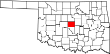
 Location in Oklahoma County and the state of Oklahoma. | |
| Coordinates: 35°28′34″N 97°11′2″W / 35.47611°N 97.18389°WCoordinates: 35°28′34″N 97°11′2″W / 35.47611°N 97.18389°W | |
| Country | United States |
| State | Oklahoma |
| County | Oklahoma |
| Area | |
| • Total | 11.9 sq mi (30.7 km2) |
| • Land | 11.9 sq mi (30.7 km2) |
| • Water | 0.0 sq mi (0.0 km2) |
| Elevation | 1,106 ft (337 m) |
| Population (2010) | |
| • Total | 5,095 |
| • Density | 428/sq mi (266/km2) |
| Time zone | Central (CST) (UTC-6) |
| • Summer (DST) | CDT (UTC-5) |
| ZIP code | 73045 |
| Area code(s) | 405 |
| FIPS code | 40-32750 |
| GNIS feature ID | 1093561[1] |
Harrah is a city in Oklahoma County, Oklahoma, United States, and a part of the Oklahoma City metropolitan area. Located 25 miles (40 km) east of downtown Oklahoma City, Harrah had a population of 5,095 people as of 2012.[2]
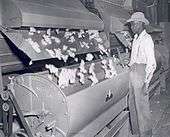
The first settler of the area, who was Potawatomi, arrived in the 1870s, but the town was not incorporated until 1908. The town was settled by Americans, Polish immigrants and other groups and had a cotton ginning center. The city is overseen by a city council and mayor and includes a police department and fire station.
Geography
Harrah is a small city in Oklahoma with a total land area of 11.9 square miles (31 km2) and no water. The city's elevation is 925 feet (282 m) above sea level.[2] It lies partly in the Great Plains near the geographical center of the 48 contiguous states in the United States. It lies between the larger cities of Oklahoma City to the west and Shawnee, Oklahoma, to the east, in Oklahoma County.
Climate
Oklahoma is located in a temperate region and experiences occasional extremes of temperature and precipitation typical of a continental climate.[3] Harrah lies in an area known as Tornado Alley characterized by frequent interaction between cold and warm air masses producing severe weather. An average of 54 tornadoes strike the state per year.[4]
The city frequently experiences temperatures above 100 °F (38 °C) or below 0 °F (−18 °C).[3]
History
The land that would become the town of Harrah had its first settler, Louis Navarre, in the 1870s.[5] Navarre, was a member of the Potawatomi people who had signed an 1867 treaty to sell their Kansas lands in order to purchase lands in Indian Territory with the proceeds. They also became citizens of the United States and thus became known as the Citizen Potawatomi.[6]

In 1890, Navarre and the Citizen Potawatomi participated, unwillingly, in the allotment process implemented through the Dawes Act of 1887. With this Act, the Citizen Potawatomi people were forced to accept individual allotments.[6] In the Land Run of 1891, the remainder of the Potawatomi reservation in Oklahoma was opened up to non-Indian settlement, with about 450 square miles (1,200 km2) of the reservation given away by the government to settlers.
Frank Harrah, for whom the town is named, purchased 40 acres (160,000 m2) from Louis Navarre's allotement in April 1898 and early settlers included a large number of Polish immigrants.[5] More than two million Poles entered American ports between 1897 and 1913, and the immigrants formed small communities around Choctaw Nation coal mines.[7]
Originally named Sweeney, after E.W. Sweeney, who operated a ferry beginning in 1891, the town was renamed Harrah on December 22, 1898, and was incorporated in 1908.[5] The town was almost renamed Clubb.[5]
In the 1940s Harrah was a center of cotton ginning. Its population was 741 in 1950.[8] By 1990 4,206 people lived in Harrah.[9]
Demographics
| Historical population | |||
|---|---|---|---|
| Census | Pop. | %± | |
| 1910 | 356 | — | |
| 1920 | 365 | 2.5% | |
| 1930 | 693 | 89.9% | |
| 1940 | 620 | −10.5% | |
| 1950 | 741 | 19.5% | |
| 1960 | 934 | 26.0% | |
| 1970 | 1,931 | 106.7% | |
| 1980 | 2,897 | 50.0% | |
| 1990 | 4,206 | 45.2% | |
| 2000 | 4,719 | 12.2% | |
| 2010 | 5,095 | 8.0% | |
| Est. 2015 | 5,891 | [10] | 15.6% |
As of the 2010 census, there were 5,095 people, 1,960 households, 1,444 families, and 155 vacant housing units in the city.[12] The population density was 428 people per square mile. The racial makeup of the city was 84% white, 1% African American, 7.3% Native American, 0.7% Asian, 0.7% from other races, and 6.3% from two or more races.[12] Hispanic or Latino of any race made up 4% of the population.[12]
Of the 1,960 households, 33% had children under the age of 18 living with them, 57.6% consisted of married couples living together, 10.8% had a female householder with no husband present, and 26.3% were non-families.[12] 22.7% of the households are occupied by a single individual and 26.1 percent had someone living alone who was 65 years of age or older.[12] The average household size was 2.57 and the average family size was 3.02.[12]
In the city the population was spread out with 25.8% under the age of 18, 30.3% from 18 to 64, and 14.5% who were 65 years of age or older.[12] The median age was 38.5 years.[12] The population is 52.1% female and 47.9% male.[12]
The median income for a household in the city was $56,302, and the median income for a family was $76,725.[13] The per capita income for the city was $25,545.[13] About 6.1% of families and 8.4% of the population were below the poverty line, including 17.1% of those under age 18 and 4.7% of those age 65 or over.[13]
City government
The City of Harrah has a city council made up of elected officials and led by a mayor. A council-appointed city manager runs the day-to-day administration of the city and oversees city staff.[14] The city also holds a municipal court twice a month.[14]
Earl Burson has served as city manager since October 2005[15] and formerly served as the city manager for Stroud, Oklahoma. As of April 2013, the city council consists of Mayor Larry Fryar and council members Kimberly Bishop, Tom Barron, Duane Patterson, and Cass Smith.[16]
The City of Harrah includes several departments, including a small fire department consisting of several paid firefighters and many volunteer firefighters. The police department includes full-time detectives, patrol officers, part-time officers, and voluntary reserve officers. The city also offers a comprehensive set of public utilities managed by the utility department and a public works department.[14]
Education
The city lies in the Harrah school district, with some western parts of the city in the Choctaw-Nicoma Park school district. Both districts offer primary and secondary school education. Harrah schools spend approximately $3,204 per student and have 16 students per teacher.[17]
Although there are no higher education institutions in Harrah, two prominent universities in Shawnee, Oklahoma are less than 30 miles away. St. Gregory's University offers undergraduate programs in multiple areas of study and a graduate program in business.[18] Oklahoma Baptist University is owned by the Baptist General Convention of Oklahoma and is ranked as Oklahoma's top regional college in the U.S. News rankings for 18 consecutive years.[19] According to The Princeton Review, the university is one of "America's Best Value Colleges."[20]
Notable people
- Dale Robertson, western actor was born in Harrah in 1923
- Paul Waner, Hall of Fame Baseball player with the Pittsburgh Pirates
- Jason Boland, Red Dirt singer and guitar player for Jason Boland and The Stragglers.
- Matt Grice, UFC Fighter
References
- ↑ "US Board on Geographic Names". United States Geological Survey. 2007-10-25. Retrieved 2008-01-31.
- 1 2 "Harrah, Oklahoma" at Sperling's Best Places Website (accessed April 14, 2013)
- 1 2 Oklahoma's Climate: an Overview, University of Oklahoma. (accessed July 26, 2013)
- ↑ Tornado Climatology, NOAA National Climatic Data Center. (accessed July 26, 2013)
- 1 2 3 4 Honea, Ted. Harrah, Encyclopedia of Oklahoma History and Culture. (accessed January 13, 2010)
- 1 2 Kraft, Lisa A. "Citizen Potawtomi," Encyclopedia of Oklahoma History and Culture. (accessed July 26, 2013)
- ↑ O'dell, Larry. Poles, Encyclopedia of Oklahoma History and Culture. (accessed July 26, 2013)
- ↑ Columbia-Lippincott Gazeteer, p. 760
- ↑ Census.gov map of Oklahoma County from 1990
- ↑ "Annual Estimates of the Resident Population for Incorporated Places: April 1, 2010 to July 1, 2015". Retrieved July 2, 2016.
- ↑ "Census of Population and Housing". Census.gov. Retrieved June 4, 2015.
- 1 2 3 4 5 6 7 8 9 United States Census Bureau 2010 Demographic Profile for Harrah, Oklahoma at American FactFinder (accessed July 26, 2013)
- 1 2 3 American FactFinder - Harrah, Oklahoma, United States Census Bureau 2007-2011 American Community Survey 5-Year Estimates (accessed July 26, 2013)
- 1 2 3 Departments, City of Harrah. (accessed January 20, 2010)
- ↑ City Manager, City of Harrah. (accessed January 20, 2010)
- ↑ City Council, City of Harrah. (accessed April 13, 2013)
- ↑ Best Places - Harrah (accessed July 26, 2013)
- ↑ A Short History of St. Gregory's Abbey
- ↑ "usnews.rankingsandreviews.com". Colleges.usnews.rankingsandreviews.com. January 31, 2011. Retrieved July 27, 2013October 14, 2011. Check date values in:
|access-date=(help) - ↑ "princetonreview.com". princetonreview.com. Retrieved October 14, 2011.
