Hoosick Falls, New York
| Hoosick Falls | |
| Village | |
 Downtown Hoosick Falls | |
| Name origin: Falls on adjacent river | |
| Country | United States |
|---|---|
| State | New York |
| Region | Capital District |
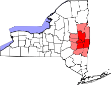
| County | Rensselaer |
| Town | Hoosick |
| River | Hoosic |
| Elevation | 443 ft (135 m) |
| Coordinates | 42°54′2″N 73°21′9″W / 42.90056°N 73.35250°WCoordinates: 42°54′2″N 73°21′9″W / 42.90056°N 73.35250°W |
| Highest point | SE corner of village |
| - elevation | 760 ft (232 m) |
| - coordinates | 42°53′54″N 73°20′11″W / 42.89833°N 73.33639°W |
| Lowest point | Hoosick River at N boundary |
| - elevation | 380 ft (116 m) |
| - coordinates | 42°54′34″N 73°21′24″W / 42.90944°N 73.35667°W |
| Area | 1.7 sq mi (4 km2) |
| Population | 3,501 (2010) |
| Founded | 1827 |
| Mayor | David B. Borge |
| Timezone | Eastern (EST) (UTC-5) |
| - summer (DST) | EDT (UTC-4) |
| ZIP Code | 12090 |
| Area code | 518 Exchange: 686 |
| FIPS code | 36-35474 |
| GNIS feature ID | 0953177 |
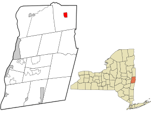 Location in Rensselaer County and the state of New York. | |
Hoosick Falls is a village in Rensselaer County, New York, United States. The population was 3,501 at the 2010 census.[1] During its peak around 1900, the village had a population of about 7,000.[2] The Capital District Regional Planning Commission projects a further decline in population through 2010 and beyond.[3]
The village of Hoosick Falls is near the center of the town of Hoosick on NY 22. The village center is listed on the National Register of Historic Places as Hoosick Falls Historic District.
Painter Grandma Moses is buried in the village.[4] The site of the British entrenchments at the Battle of Bennington, 6 August 1777, is nearby and is maintained as Bennington Battlefield State Historic Site.[5]
History
Although this has been an issue of considerable debate, it's believed the first documented settlers came to Hoosick Falls on the Hoosic River, around 1746. Encyclopedia Americana reports the date of the first permanent settlement as 1688.[5] The French drove the settlers out in 1754 and most of the settlement was burned, but they returned and rebuilt after the French & Indian War ended. Hoosick Falls was incorporated as a village in 1827.
Walter A. Wood Mowing and Reaping Machine Co. In 1852 a blacksmith named Walter A. Wood began manufacturing a reaper in Hoosick Falls. By the 1890s the Walter A. Wood Mowing & Reaping Company was the largest farm machinery manufacturer in the world, taking up 85 acres (340,000 m2) on the west bank of the river. The Wood Company closed in 1924, mainly due to the introduction of John Deere's revolutionary self-propelled farm equipment. Most of these facilities were used by the Colasta Corporation from the mid-1920s until the late 1950s. This company manufactured radio parts. Later, parts of this site were used as a lumber yard/hardware store. A rash of arson fires in the mid and late 1970s consumed the entire complex. The only buildings still in use today are outside of the main complex, the Interface Solutions Plant (formerly the Wood-Flong Paper Mill), which was Walter A Wood's steel foundry. The original Office Building is still present also.
Along with the Walter Wood plant, Hoosick Falls was a boomtown in the 19th century. Many other businesses came into town, bringing people and money with them. Hoosick Falls once had factories that made Paper, small numbers of Appliances, Parts, Glass, and some nominal Soda and Beer Bottling Plants. A large number of rich Victorian homes were built during this period and are still there today, most in good shape. This was also a regional center of Trade and Export. Local farmers and manufacturers would come to town to sell their goods and load them on rail cars bound for New York City or abroad. These goods consisted of manufacturers, grain, milk, livestock, construction materials (mostly slate and brick), paper & pulp, timber and beverages.
The village faced an Environmental Crisis due to high levels of potentially cancer causing PFOA being detected in the Municipal Water Supply. The high levels of PFOA were not relayed to residents for over a year after first detected by the New York State Department of Health.[6] It was announced on March 30, 2016 that “repeated testing of the village of Hoosick Falls' municipal water system shows non detection of Perfluorooctanoic acid (PFOA) and is now safe for all uses including drinking and cooking.”[7]
The Estabrook Octagon House, Hoosick Falls Armory, Hoosick Falls Historic District, St. Mark's Episcopal Church, and United States Post Office are listed on the National Register of Historic Places.[8][9]
Geography
According to the United States Census Bureau, the village has a total area of 1.7 square miles (4.4 km2), all land.
The village is divided by the Hoosic River.
Hoosick Falls is bisected by NY Route 22. Public transportation to and from the village is provided between Albany and Bennington, Vermont by Yankee Trails World Travel's weekday-running Albany-Bennington Shuttle bus.[10]
Demographics
| Historical population | |||
|---|---|---|---|
| Census | Pop. | %± | |
| 1880 | 4,530 | — | |
| 1890 | 7,014 | 54.8% | |
| 1900 | 5,671 | −19.1% | |
| 1910 | 5,532 | −2.5% | |
| 1920 | 4,896 | −11.5% | |
| 1930 | 4,755 | −2.9% | |
| 1940 | 4,279 | −10.0% | |
| 1950 | 4,297 | 0.4% | |
| 1960 | 4,023 | −6.4% | |
| 1970 | 3,897 | −3.1% | |
| 1980 | 3,609 | −7.4% | |
| 1990 | 3,490 | −3.3% | |
| 2000 | 3,436 | −1.5% | |
| 2010 | 3,501 | 1.9% | |
| Est. 2015 | 3,432 | [11] | −2.0% |
As of the census[1] of 2000, there were 3,436 people, 1,382 households, and 880 families residing in the village.The population density was 1,998.8 persons per square mile (771.3/km²). There were 1,553 housing units at an average density of 903.4 per square mile (348.6/km²). The racial makeup of the village was 97.58% White, 0.55% African American, 0.41% Native American, 0.49% Asian, 0.06% Pacific Islander, 0.32% from other races, and 0.58% from two or more races. Hispanic or Latino of any race were 0.99% of the population.
There were 1,382 households out of which 32.1% had children under the age of 18 living with them, 47.5% were married couples living together, 12.4% had a female householder with no husband present, and 36.3% were non-families. 30.9% of all households were made up of individuals and 15.4% had someone living alone who was 65 years of age or older. The average household size was 2.43 and the average family size was 3.05. In the village the population was spread out with 25.9% under the age of 18, 8.4% from 18 to 24, 28.2% from 25 to 44, 19.5% from 45 to 64, and 18.0% who were 65 years of age or older. The median age was 38 years. For every 100 females there were 89.7 males. For every 100 females age 18 and over, there were 85.8 males.
The median income for a household in the village was $36,731, and the median income for a family was $45,829. Males had a median income of $33,750 versus $23,313 for females. The per capita income for the village was $18,062. About 5.1% of families and 6.6% of the population were below the poverty line, including 8.6% of those under age 18 and 4.6% of those age 65 or over.
Notable people
- Bob Eberly and Ray Eberle, brothers and Big Band singers.[13]
- Private Harris S. Hawthorn, received the Medal of Honor for capturing Gen. Custis Lee (the son of Gen. Robert E. Lee) on April 6, 1865 at the Battle of Sailor's Creek, Virginia; he is buried in the Maple Grove Cemetery.[14]
- Harriet Hoctor, ballerina, dancer, Broadway theatre and Hollywood actress was born in the village.[15]
- Jenny Holzer, the conceptual artist, lives and works here.
- Alexander Ney, the Soviet emigre artist currently lives and works here.[16]
- Jill Reeve, Former member of the United States women's national field hockey team[17]
- Grandma Moses, renowned folk artist, lived here in the latter part of her life. Her work was first discovered by an art collector who noticed one of her paintings, many of which depicted Hoosick Falls and its surroundings, hanging in a local drug store.[18]
- Harry Van Surdam, who "devised one of the first legal forward pass plays ever used by a college team," according to the Oklahoma Daily, in a 1966 article. In 1972, he was placed in the National Football Hall of Fame; the award hangs in the foyer of the Hoosick Falls Central School.[19]
- Lewis A. Swyer, owner of a construction company that built many historic Albany landmarks, was born and spent early childhood in Hoosick Falls. His company, L.A. Swyer Co. Inc., built Albany landmarks including the Hilton Hotel, Ten Eyck Plaza, Twin Towers, State Street Centre, Bleecker Terrace Apartments, Albany Law School library and Temple Beth Emeth.[20][21]
- Jose de Creeft, Spanish sculptor who created the famous statue of Alice and Wonderland in New York City's Central Park, had a house just outside Hoosick Falls. His ashes are buried beneath one of his sculptures in a park along Main street.[22]
- George Verschoor, Verschoor developed, produced and directed the first four seasons of MTV's groundbreaking series The Real World, which launched the modern non-fiction genre and is one of the longest-running reality programs in history.
References
- 1 2 "American FactFinder". United States Census Bureau. Retrieved 2008-01-31.
- ↑ "Walter A. Wood Mowing and Reaping Machine Company". Hoosick Township Historical Society. Retrieved 2009-07-20.
- ↑ "Capital District Population & Projections". Capital District Regional Planning Commission. Retrieved 2009-07-20.
- ↑ "Biography of Grandma Moses". Hoosick Township Historical Society. Retrieved 2009-07-20.
- 1 2
 Rines, George Edwin, ed. (1920). "Hoosick Falls". Encyclopedia Americana.
 - ↑ McKinley, Jesse (7 September 2016). "Lawmakers Skeptical of State's Explanation for Hoosick Falls Water Crisis". NY Times. Retrieved 8 September 2016.
- ↑ http://www.health.ny.gov/press/releases/2016/2016-03-30_hoosick_falls.htm
- ↑ National Park Service (2010-07-09). "National Register Information System". National Register of Historic Places. National Park Service.
- ↑ "National Register of Historic Places Listings". Weekly List of Actions Taken on Properties: 10/01/12 through 10/05/12. National Park Service. 2012-10-12.
- ↑ Bennington, VT Bus Service, Yankee Trails World Travel. Retrieved 2015-04-25.
- ↑ "Annual Estimates of the Resident Population for Incorporated Places: April 1, 2010 to July 1, 2015". Retrieved July 2, 2016.
- ↑ "Census of Population and Housing". Census.gov. Retrieved June 4, 2015.
- ↑ "The Eberle Brothers". Hoosick Township Historical Society. Retrieved 2009-07-23.
- ↑ "Harris Smith Hawthorn". Hoosick Township Historical Society. Retrieved 2009-07-23.
- ↑ "Harriet Hoctor". Hoosick Township Historical Society. Retrieved 2009-07-23.
- ↑ "In Eviction From Diamond District, Losing Much More Than Home". New York Times. 2015-04-02. Retrieved 2016-05-05.
- ↑ "Jill Reeve biography". sports-reference.com. Retrieved 2009-07-23.
- ↑ "Grandma Moses". Hoosick Township Historical Society. Retrieved 2015-02-28.
- ↑ "Harry van Surdam". Hoosick Township Historical Society. Retrieved 2009-07-23.
- ↑ "Lewis A. Swyer". New York Times. 1988-12-27. Retrieved 2011-12-26.
- ↑ "Lewis A. Swyer". Albany Times Union. Retrieved 2011-12-26.
- ↑ "Jose De Creeft, 97, Sculptor, Is Dead". The New York Times. 1982-09-12.
Further reading
- Anderson, George Baker (1897). Landmarks of Rensselaer County New York. Syracuse, New York: D. Mason and Company. OCLC 1728151.
- Hayner, Rutherford (1925). Troy and Rensselaer County New York: A History. New York: Lewis Historical Publishing Company, Inc. OCLC 22524006.
- Sylvester, Nathaniel Bartlett (1880). History of Rensselaer Co., New York with Illustrations and Biographical Sketches of its Prominent Men and Pioneers. Philadelphia: Everts & Peck. OCLC 3496287.
- Weise, Arthur James (1880). History of the Seventeen Towns of Rensselaer County from the Colonization of the Manor of Rensselaerwyck to the Present Time. Troy, New York: J. M. Francis & Tucker. OCLC 6637788.
External links
| Wikimedia Commons has media related to Hoosick Falls, New York. |
Municipalities and communities of Rensselaer County, New York, United States | ||
|---|---|---|
| Cities | 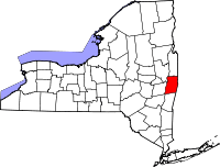 | |
| Towns | ||
| Villages | ||
| CDPs | ||
| Other hamlets | ||