Soultz-Haut-Rhin
| Soultz-Haut-Rhin | ||
|---|---|---|
 | ||
| ||
 Soultz-Haut-Rhin | ||
|
Location within Grand Est region  Soultz-Haut-Rhin | ||
| Coordinates: 47°53′10″N 7°13′47″E / 47.886°N 7.2297°ECoordinates: 47°53′10″N 7°13′47″E / 47.886°N 7.2297°E | ||
| Country | France | |
| Region | Grand Est | |
| Department | Haut-Rhin | |
| Arrondissement | Thann-Guebwiller | |
| Canton | Guebwiller | |
| Intercommunality | Région de Guebwiller | |
| Government | ||
| • Mayor (2008–2014) | Thomas Birgaentzlé | |
| Area1 | 29.56 km2 (11.41 sq mi) | |
| Population (2009)2 | 7,311 | |
| • Density | 250/km2 (640/sq mi) | |
| Time zone | CET (UTC+1) | |
| • Summer (DST) | CEST (UTC+2) | |
| INSEE/Postal code | 68315 / 68360 | |
| Elevation |
239–1,421 m (784–4,662 ft) (avg. 270 m or 890 ft) | |
|
1 French Land Register data, which excludes lakes, ponds, glaciers > 1 km² (0.386 sq mi or 247 acres) and river estuaries. 2 Population without double counting: residents of multiple communes (e.g., students and military personnel) only counted once. | ||

Soultz-Haut-Rhin (German: Sulz/Oberelsaß) is a commune in the Haut-Rhin département in Grand Est in north-eastern France.
Its inhabitants are called Soultziens (male) or Soultziennes (female).
Geography
The town of Soultz-Haut-Rhin has an enclave located northeast of Goldbach-Altenbach.
The town of Soultz was built around a salted water source from which originates its name.
History
The origins of Soultz go back to the 7th century.
667 : the written name of Sulza (salted source) is mentioned in a donation from Adalrich, Duke of Alsace, father of Saint Odile, of the bann of Soultz to the convent of Ebersmunster.
Demography
- 1962 : 4750
- 1968 : 4910
- 1975 : 5689
- 1982 : 5696
- 1990 : 5867
- 1999 : 6640
- 2006 : 7184
Places of interest
Soultz has houses from the 16th, 17th and 18th centuries.
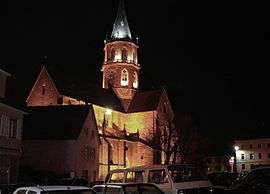
- The Church Saint-Mauritius, l'église Saint-Maurice (1270–1489)
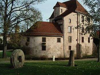
- Château de Buchenek is a 13th-century castle, now a museum
- La Nef des Jouets (The Toys Vessel, museum of toys)
People
- Georges-Charles de Heeckeren d'Anthès, who married Catherine Gontcharoff, eldest sister of Alexander Pushkin's wife, and killed Pushkin in a duel.
- Auguste-César West (1810–1880), prefect of Haut-Rhin from 1848 to 1850 then prefect of Bas-Rhin until 1855 and of Haute-Garonne until 1859.
- Bernard Genghini, footballer, born in 1958 in Soultz
- Pierre Villon (1901–1980), whose real name was Pierre Ginsburger, was a French political figure who took part in the Resistance.
- Katia Krafft, volcanologist, born in 1942 in Soultz. Wife of the volcanologist Maurice Krafft. Both of them were carried off in 1991 by a pyroclastical flow on the sides of the Mount Unzen (Japan).
See also
References
External links
| Wikimedia Commons has media related to Soultz-Haut-Rhin. |
- Site officiel de la mairie de Soultz
- Soultz-Haut-Rhin on the Institut géographique national website
- Soultz-Haut-Rhin on the INSEE website
- Soultz-Haut-Rhin sur le site du Quid
- Localisation de Soultz-Haut-Rhin sur une carte de France et communes limitrophes
- Plan de Soultz-Haut-Rhin sur Mapquest