Magstatt-le-Bas
| Magstatt-le-Bas Màschgetz | ||
|---|---|---|
| ||
 Magstatt-le-Bas | ||
|
Location within Grand Est region  Magstatt-le-Bas | ||
| Coordinates: 47°38′22″N 7°24′35″E / 47.6394°N 7.4097°ECoordinates: 47°38′22″N 7°24′35″E / 47.6394°N 7.4097°E | ||
| Country | France | |
| Region | Grand Est | |
| Department | Haut-Rhin | |
| Arrondissement | Mulhouse | |
| Canton | Sierentz | |
| Intercommunality | Pays de Sierentz | |
| Government | ||
| • Mayor (2001–2008) | Lucien Brunner | |
| Area1 | 3.35 km2 (1.29 sq mi) | |
| Population (2006)2 | 471 | |
| • Density | 140/km2 (360/sq mi) | |
| Time zone | CET (UTC+1) | |
| • Summer (DST) | CEST (UTC+2) | |
| INSEE/Postal code | 68197 / 68510 | |
| Elevation |
287–395 m (942–1,296 ft) (avg. 310 m or 1,020 ft) | |
|
1 French Land Register data, which excludes lakes, ponds, glaciers > 1 km² (0.386 sq mi or 247 acres) and river estuaries. 2 Population without double counting: residents of multiple communes (e.g., students and military personnel) only counted once. | ||
.svg.png)
Magstatt-le-Bas (Alemannic German: Màschgetz; German: Niedermagstatt) is a commune in the Haut-Rhin department in Alsace in north-eastern France.
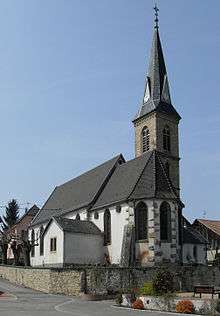
Saint-Michel Church
See also
References
| Wikimedia Commons has media related to Magstatt-le-Bas. |
This article is issued from Wikipedia - version of the 6/23/2015. The text is available under the Creative Commons Attribution/Share Alike but additional terms may apply for the media files.