Interstate 37
| ||||
|---|---|---|---|---|
|
I-37 highlighted in red | ||||
| Route information | ||||
| Maintained by TxDOT | ||||
| Length: | 143.00 mi[1] (230.14 km) | |||
| Existed: | October 16, 1959[2] – present | |||
| Major junctions | ||||
| South end: |
| |||
| North end: |
| |||
| Location | ||||
| Counties: | Nueces, San Patricio, Live Oak, Atascosa, Bexar | |||
| Highway system | ||||
| ||||


Interstate 37 (I-37) is a 143.0-mile (230.1 km) Interstate Highway located within the southern portion of the U.S. state of Texas. The highway was first designated in 1959 as a route between Corpus Christi and San Antonio. Construction in the urban areas of Corpus Christi and San Antonio began in the 1960s and the segments of the Interstate Highway in rural areas were completed by the 1980s. Prior to I-37, the route between Corpus Christi and San Antonio was served by a combination of State Highway 9 (SH 9) from Corpus Christi to Three Rivers and U.S. Route 281 (US 281) from Three Rivers to San Antonio. As a result of the construction of I-37, SH 9 was removed from the State Highway System.
The highway begins in Corpus Christi at US 181 and SH 35 and heads north to San Antonio, where it ends at I-35. Beyond I-35, the freeway continues as US 281 to northern San Antonio as a major freeway. In Corpus Christi, the highway provides access to the downtown area, the Port of Corpus Christi, and the Corpus Christi International Airport. In San Antonio, it provides access to Downtown, Brooks City-Base, the Alamodome, the Tower of the Americas, the River Walk, the Alamo, and by extension via US 281, the San Antonio International Airport. The route provides an important connection between I-35 and the Texas Gulf Coast as well as one of the few limited-access hurricane evacuation routes away from the southern Texas coast.
Route description
Interstate 37 starts near the Gulf Coast in Corpus Christi and heads northwest toward San Antonio.[2] It links South Texas to the northern parts of the state via I-69E, US 77, and US 281. The highway functions as one of the few freeway hurricane evacuation routes for the southern Texas coast. It roughly parallels US 181, which both begins and ends at I-37, and US 281.[3]

Unofficially, I-37 begins at an intersection with Shoreline Boulevard on the edge of Corpus Christi Bay. It then heads west as a surface street for three blocks where it becomes entrance and exit ramps which connect to the freeway.[4] I-37 begins officially at the gore point for these ramps, which is part of an interchange complex that also represents the southern ends of US 181 and SH 35.[5]
It heads west from US 181 through Corpus Christi and intersects two freeways, SH 286 (the Crosstown Expressway) and SH 358 (Padre Island Drive). The highway turns towards the northwest after the SH 358 interchange roughly parallel to the south of the Nueces River. Just prior to leaving the Corpus Christi city limits, it intersects and has a short concurrency with US 77 (future I-69E). US 77 (future I-69E) merges with I-37 as a freeway from the south; the two continue to the north and split after crossing the Nueces River. The Interstate continues to the northwest as US 77 (future I-69E) continues to the northeast.[6]
I-37 transitions to a rural setting once outside of the Corpus Christi city limits on its way to Mathis and Lake Corpus Christi. It continues on to the northwest and intersects US 59 (future I-69W) east of George West. It begins paralleling US 281 to the east before the two intersect and have a concurrency north of Three Rivers near Choke Canyon Reservoir. U.S. Highway 281 Alternate (US 281 Alt) splits off from I-37 near Sunniland and parallels I-37 before rejoining north of Campbellton. The two routes remain concurrent until US 281 splits off to head to Pleasanton, while I-37 bypasses the city to the east. After US 281 leaves towards the northwest, I-37 turns to the north towards San Antonio.[6]
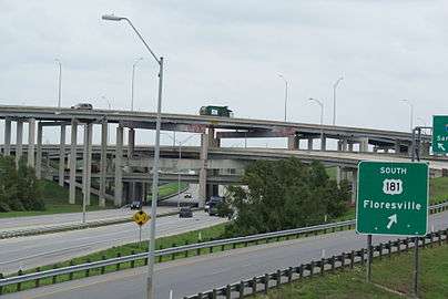
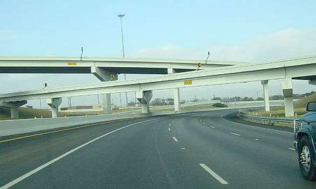
As I-37 enters the San Antonio city limits, it intersects the northern terminus of US 181. Continuing to the north, it intersects I-410, the inner loop around San Antonio, at a stack interchange. At this junction, the Interstate once again runs concurrently with US 281 which had been concurrent with I-410. Heading north through the south side of San Antonio, I-37 provides access to Brooks City-Base (formerly Brooks AFB). After a cloverleaf interchange at Loop 13, the freeway turns towards the northwest. The highway intersects I-10, which is concurrent with US 90 and US 87, at a stack interchange on the southeastern corner of Downtown. After the interchange, it once again heads north on the east side of Downtown. It passes near the Alamodome, the Tower of the Americas, the River Walk and the Alamo. I-37 ends at the northeastern corner of Downtown at a junction with I-35. US 281 continues to the north as a freeway and provides access to the San Antonio International Airport and later far north central Texas.[6]
From I-410 to I-10 in San Antonio, I-37 is designated the Lucian Adams Freeway, after the World War II veteran. Adams is a native of Port Arthur, and received the Medal of Honor for his service in France, along with the Bronze Star and Purple Heart for his gallantry during the Cassino Campaign.[7] From I-10 to its northern terminus at I-35, it is designated the Staff Sergeant William J. Bordelon Freeway. Bordelon was the first San Antonio native to receive the Medal of Honor after being killed in action during World War II.[8][9]
History
Prior to I-37, the routing between Corpus Christi and San Antonio was covered by SH 9 from Corpus Christi to Three Rivers and US 281 from Three Rivers to San Antonio. Beginning in 1971, sections of SH 9 were officially removed from the State Highway System as I-37 was completed.[10] No sections of US 281 were removed from the State Highway System as a result of the construction of I-37, but the two do share the same alignment at two different points between San Antonio and Three Rivers. Also, US 281 was rerouted onto I-37 in San Antonio in 1978.[6][11][12]
I-37 was first designated in 1959 to provide a route between San Antonio and Corpus Christi.[2] Construction began in the 1960s and the route was completed by the 1980s.[3] The first sections of the freeway completed were in Corpus Christi. The freeway was completed from its southern terminus to 1.2 miles (1.9 km) to the west at the Port Avenue overpass to include the SH 286 interchange in 1963.[13][14][15][16][17] In 1964, the freeway was extended another 1.1 miles (1.8 km) westward with the completion of the overpasses at Nueces Bay Boulevard and Buddy Lawrence Boulevard.[18][19][20] By 1965, the freeway had been extended west 1.4 miles (2.3 km) to Navigation Boulevard.[21][22] In 1966, the interchange at SH 358 was complete, as were the mainlanes to Corn Products Road, 1.0 mile (1.6 km) west of the SH 358 interchange.[23][24][25] By 1968, the freeway had been completed an additional 8.1 miles (13.0 km) further west to Callicoatte Road.[26][27] The southbound I-37 bridge over the Nueces River was built in 1933 for US 77 (future I-69E) when it was first routed through Corpus Christi.[28][29] The northbound bridge was built in 1958 with the expansion of US 77 (future I-69E) to four lanes.[30]

Construction in San Antonio also began in the 1960s and was completed in 1972. The first sections were completed in 1967 to include the portion just south of I-410 at the US 181 interchange.[31] The section from Steves Avenue north to Florida Street to include the I-10 interchange was also complete in 1967.[32][33][34] In 1968, the section south of I-410 was extended south to Loop 1604.[35] In 1969, the two sections were connected with the completion of overpasses at Goliad Road, Pecan Valley Drive, Fair Avenue and Hackberry Street as well as the completion of the interchanges at I-410 and Loop 13.[36][37][38][39][40][41] The last sections left were on the east side of downtown. The downtown overpasses at Durango Boulevard, Commerce Street and the overpass stretching from Houston Street to Jones Avenue were all completed in 1972.[42][43][44] The last portion completed in San Antonio was the stack interchange at I-35 (also known as the San Antonio "Downtown Mixer"), near the Pearl Brewery. With the completion of the interchange in 1972,[45] the city had a complete freeway loop in conjunction with I-10 and I-35 around the central business district of the city. At the time construction began in July 1969, the I-35 interchange was the largest highway construction project in state history at $11 million ($65 million in 2007).[46]
The rural sections of the freeway were completed later than those in the urban areas. Construction of the highway in Corpus Christi and Nueces County continued north over the Nueces River into San Patrico County. The interchange at US 77 (future I-69E) was completed in 1969.[47] The road that was already in existence along this stretch, SH 9, would be utilized as a frontage road as many of the bridges along this stretch were from when SH 9 was built in the 1930s.[48][49] The main lanes were extended northward to SH 234 in 1969.[50] By 1970, the freeway had been extended as far north as SH 188.[51] In 1971, I-37 reached FM 888 and service to the city of Mathis.[52] During the mid-1970s, the southern section and northern section were both being extended. The southern section was extended northward in Live Oak County to US 59 (future I-69W) in 1975 and FM 799 in 1976.[53][54] The northern section saw completion in Atascosa County to FM 541 in 1975 and FM 1099 in 1976.[55][56] By the early 1980s, the freeway was nearly complete. In 1980, the interchange at US 281 southeast of Pleasanton was complete.[57] With the completion of the interchange at SH 72 and other bridges in the Pleasanton area in 1981, I-37 was complete.[58][59]
Exit list
| County | Location | mi | km | Exit[60] | Destinations | Notes |
|---|---|---|---|---|---|---|
| Nueces | Corpus Christi | 0.000 | 0.000 | 0 | Southbound exit and northbound entrance, southern terminus | |
| 0.253 | 0.407 | 1A | Buffalo Street | Southbound exit and northbound entrance | ||
| 0.338 | 0.544 | 1B | Brownlee Boulevard, Port Avenue | Northbound exit and southbound entrance | ||
| 0.462– 0.728 | 0.744– 1.172 | 1C | Access to Spohn Memorial Hospital | |||
| 1.132 | 1.822 | 1D | Port Avenue | Southbound exit and northbound entrance | ||
| 1.379– 2.293 | 2.219– 3.690 | 1E | Lawrence Drive, Nueces Bay Boulevard | |||
| 2.781 | 4.476 | 2 | Up River Road | |||
| 3A | Navigation Boulevard | |||||
| 3B | McBride Lane, Lantana Street | Northbound exit and southbound entrance | ||||
| 4A | ||||||
| 4B | Lantana Street, McBride Lane | Southbound exit and northbound entrance | ||||
| 5 | Corn Products Road / Valero Way | |||||
| 6 | Southern Minerals Road | |||||
| 7 | Tuloso Road, Suntide Road | |||||
| 9 | ||||||
| 10 | Carbon Plant Road/Joe Fulton Int'l Trade Corridor | Southbound exit leads to Carbon Plant Road | ||||
| 10A | Joe Fulton Int'l Trade Corridor | southbound exit; northbound exit is part of exit 10 | ||||
| 11A | ||||||
| 11B | ||||||
| 13A | ||||||
| 13B | Sharpsburg Road | Northbound exit and southbound entrance | ||||
| 14A | South end of US 77 overlap; current northern end of I-69E, signed as exit 14 southbound; I-69E currently signed as I-69 southbound and I-69E northbound | |||||
| 14B | Red Bird Lane | Northbound exit and southbound entrance | ||||
| 15 | Sharpsburg Road, Red Bird Lane | Southbound exit and northbound entrance | ||||
| 16 | Labonte Park | |||||
| San Patricio | | 17 | North end of US 77 overlap, Future I-69E | |||
| | 20A | Picnic Area | ||||
| | 20B | Cooper Road | ||||
| Edroy | 22 | |||||
| | 31 | |||||
| Mathis | 34 | |||||
| 36 | ||||||
| Live Oak | | 40 | ||||
| | 47 | |||||
| | 51 | Hailey Ranch Road | ||||
| | 56 | Future I-69W | ||||
| | 59 | |||||
| | 65 | |||||
| | 69 | |||||
| | 72 | South end of US 281 overlap | ||||
| | 76 | |||||
| | 83 | |||||
| Atascosa | | 88 | ||||
| | 92 | Southbound exit and northbound entrance | ||||
| | 98 | |||||
| | 103 | North end of US 281 overlap; northbound exit and southbound entrance | ||||
| | 104 | No southbound entrance | ||||
| | 106 | Coughran Road | ||||
| | 109 | |||||
| | 113 | |||||
| | 117 | |||||
| Bexar | | 120 | Hardy Road | |||
| | 122 | Priest Road/Mathis Road | ||||
| | 125 | |||||
| | 127 | San Antonio River Turnaround | Northbound exit and southbound entrance | |||
| San Antonio | 130 | Southton Road, Donop Road | ||||
| 132 | Northbound exit and southbound entrance | |||||
| 132 | Southbound exit and northbound entrance | |||||
| 133 | South end of US 281 overlap; I-410 exit 41 | |||||
| 135 | Access to Stinson Municipal Airport and Mission Trail Baptist Hospital | |||||
| 136 | Pecan Valley Drive | |||||
| 137 | Hot Wells Boulevard | |||||
| 138 | New Braunfels Avenue, Southcross Boulevard | Signed as exits 138A (east) and 138B (west) southbound | ||||
| 138C | Fair Avenue, Hackberry Street | |||||
| 139 | I-10 exit 575A | |||||
| 140A | Florida Street, Carolina Street | |||||
| 140B | Cesar Chavez Boulevard – Alamodome | |||||
| 141A | Commerce Street – Downtown San Antonio | Signed as exit 141 southbound | ||||
| 141B | Houston Street – The Alamo | Southbound exit and northbound entrance | ||||
| 141C | McCullough Avenue, Nolan Street | Southbound exit and northbound entrance | ||||
| 142 | Signed as exits 142A (north) and 142B (south); I-35 exit 158; northern terminus; roadway continues beyond I-35 as US 281 | |||||
1.000 mi = 1.609 km; 1.000 km = 0.621 mi
| ||||||
See also
 Texas portal
 U.S. Roads portal
References
- ↑ DeSimone, Tony (January 19, 2012). "Table 1: Main Routes of the Dwight D. Eisenhower National System Of Interstate and Defense Highways as of October 31, 2002". Route Log and Finder List. Federal Highway Administration. Retrieved March 5, 2012.
- 1 2 3 Transportation Planning and Programming Division (n.d.). "Interstate Highway No. 37". Highway Designation Files. Texas Department of Transportation. Retrieved February 27, 2008.
- 1 2 Beaumont, Penny; Brinkmann, Rhonda; Ellis, David; Pourteau, Chris; Webb, Brandon V. (2006). From Anywhere to Everywhere: The Development of the Interstate Highway System in Texas (PDF) (Report). Texas Transportation Institute. p. 32. Archived from the original (PDF) on January 7, 2008. Retrieved February 25, 2008.
- ↑ Google (April 20, 2013). "East of I-37 in Corpus Christi" (Map). Google Maps. Google. Retrieved April 20, 2013.
- ↑ "Maps & Data" (ESRI shapefile). Texas Natural Resources Information System. 2012. Retrieved April 20, 2013.
- 1 2 3 4 Google (February 25, 2008). "Overview map of I-37" (Map). Google Maps. Google. Retrieved February 25, 2008.
- ↑ Staff. "Lucian Adams". Texas State Cemetery. Retrieved February 27, 2008.
- ↑ "Signs designating William J. Bordelon Expressway unveiled". Central Catholic High School. September 14, 2009. Retrieved April 9, 2011.
- ↑ Leatherwood, Art. "Bordelon, William James". Handbook of Texas Online. Texas State Historical Association. Retrieved April 9, 2011.
- ↑ Transportation Planning and Programming Division (n.d.). "State Highway No. 9". Highway Designation Files. Texas Department of Transportation. Retrieved February 27, 2008.
- ↑ Transportation Planning and Programming Division (n.d.). "State Highway Spur No. 536". Highway Designation Files. Texas Department of Transportation. Retrieved March 8, 2008.
- ↑ Transportation Planning and Programming Division (n.d.). "State Highway Spur No. 537". Highway Designation Files. Texas Department of Transportation. Retrieved March 8, 2008.
- ↑ Staff. "Staples Street overpass". National Bridge Inventory. Federal Highway Administration. Retrieved February 29, 2008.
- ↑ Staff. "Brownlee Street overpass". National Bridge Inventory. Federal Highway Administration. Retrieved February 29, 2008.
- ↑ Staff. "SH 286 interchange". National Bridge Inventory. Federal Highway Administration. Retrieved February 29, 2008.
- ↑ Staff. "Port Avenue overpass". National Bridge Inventory. Federal Highway Administration. Retrieved February 29, 2008.
- ↑ Google (April 7, 2008). "Southern terminus to Port Avenue" (Map). Google Maps. Google. Retrieved April 7, 2008.
- ↑ Staff. "Nueces Bay Boulevard overpass". National Bridge Inventory. Federal Highway Administration. Retrieved February 29, 2008.
- ↑ Staff. "Buddy Lawrence Boulevard overpass". National Bridge Inventory. Federal Highway Administration. Retrieved February 29, 2008.
- ↑ Google (April 7, 2008). "Port Avenue to Buddy Lawrence Boulevard" (Map). Google Maps. Google. Retrieved April 7, 2008.
- ↑ Staff. "Navigation Boulevard overpass". National Bridge Inventory. Federal Highway Administration. Retrieved February 29, 2008.
- ↑ Google (April 7, 2008). "Buddy Lawrence Boulevard to Navigation Boulevard" (Map). Google Maps. Google. Retrieved April 7, 2008.
- ↑ Staff. "SH 358 interchange". National Bridge Inventory. Federal Highway Administration. Retrieved February 29, 2008.
- ↑ Staff. "Corn Products Road overpass". National Bridge Inventory. Federal Highway Administration. Retrieved February 29, 2008.
- ↑ Google (April 7, 2008). "SH 358 to Corn Products Road" (Map). Google Maps. Google. Retrieved April 7, 2008.
- ↑ Staff. "Callicoatte Road overpass". National Bridge Inventory. Federal Highway Administration. Retrieved February 29, 2008.
- ↑ Google (April 7, 2008). "Corn Products Road to Callicoatte Road" (Map). Google Maps. Google. Retrieved April 7, 2008.
- ↑ Staff. "Southbound Nueces River bridge". National Bridge Inventory. Federal Highway Administration. Retrieved February 29, 2008.
- ↑ Transportation Planning and Programming Division (n.d.). "U.S. Highway No. 77". Highway Designation Files. Texas Department of Transportation. Retrieved February 29, 2008.
- ↑ Staff. "Northbound Nueces River bridge". National Bridge Inventory. Federal Highway Administration. Retrieved February 29, 2008.
- ↑ Staff. "US 181 interchange". National Bridge Inventory. Federal Highway Administration. Retrieved February 29, 2008.
- ↑ Staff. "Steves Avenue overpass". National Bridge Inventory. Federal Highway Administration. Retrieved February 29, 2008.
- ↑ Staff. "Florida Street overpass". National Bridge Inventory. Federal Highway Administration. Retrieved February 29, 2008.
- ↑ Staff. "I-10 interchange". National Bridge Inventory. Federal Highway Administration. Retrieved February 29, 2008.
- ↑ staff. "Loop 1604 overpass". National Bridge Inventory. Federal Highway Administration. Retrieved February 29, 2008.
- ↑ Staff. "Goliad Road overpass". National Bridge Inventory. Federal Highway Administration. Retrieved February 29, 2008.
- ↑ Staff. "Pecan Valley Drive overpass". National Bridge Inventory. Federal Highway Administration. Retrieved February 29, 2008.
- ↑ Staff. "Fair Avenue overpass". National Bridge Inventory. Federal Highway Administration. Retrieved February 29, 2008.
- ↑ Staff. "Hackberry Street overpass". National Bridge Inventory. Federal Highway Administration. Retrieved February 29, 2008.
- ↑ Staff. "I-410 interchange". National Bridge Inventory. Federal Highway Administration. Retrieved February 29, 2008.
- ↑ Staff. "Loop 13 interchange". National Bridge Inventory. Federal Highway Administration. Retrieved February 29, 2008.
- ↑ Staff. "Durango Boulevard overpass". National Bridge Inventory. Federal Highway Administration. Retrieved February 29, 2008.
- ↑ Staff. "Commerce Street overpass". National Bridge Inventory. Federal Highway Administration. Retrieved February 29, 2008.
- ↑ Staff. "Houston Street to Jones Avenue overpass". National Bridge Inventory. Federal Highway Administration. Retrieved February 29, 2008.
- ↑ Staff. "IH 35 & IH 37 interchange". National Bridge Inventory. Federal Highway Administration. Retrieved February 29, 2008.
- ↑ Kelly, Frank G. (June 1971). "Where the Freeways Meet". Texas Highways. Retrieved February 27, 2008.
- ↑ Staff. "US 77 interchange". National Bridge Inventory. Federal Highway Administration. Retrieved February 29, 2008.
- ↑ "Arroyo Nombre de Dios Bridge". National Bridge Inventory. Federal Highway Administration. Retrieved February 29, 2008.
- ↑ Staff. "SH 234 frontage overpass". National Bridge Inventory. Federal Highway Administration. Retrieved February 29, 2008.
- ↑ Staff. "SH 234 overpass". National Bridge Inventory. Federal Highway Administration. Retrieved February 29, 2008.
- ↑ Staff. "SH 188 overpass". National Bridge Inventory. Federal Highway Administration. Retrieved February 29, 2008.
- ↑ Staff. "FM 888 overpass". National Bridge Inventory. Federal Highway Administration. Retrieved February 29, 2008.
- ↑ Staff. "US 59 interchange". National Bridge Inventory. Federal Highway Administration. Retrieved February 29, 2008.
- ↑ Staff. "FM 799 interchange". National Bridge Inventory. Federal Highway Administration. Retrieved February 29, 2008.
- ↑ Staff. "FM 541 interchange". National Bridge Inventory. Federal Highway Administration. Retrieved February 29, 2008.
- ↑ Staff. "FM 1099 interchange". National Bridge Inventory. Federal Highway Administration. Retrieved February 29, 2008.
- ↑ Staff. "US 281 interchange". National Bridge Inventory. Federal Highway Administration. Retrieved February 29, 2008.
- ↑ Staff. "SH 72 interchange". National Bridge Inventory. Federal Highway Administration. Retrieved February 29, 2008.
- ↑ Staff. "Rock Quarry Branch Bridge". National Bridge Inventory. Federal Highway Administration. Retrieved February 29, 2008.
- ↑ Statewide Planning Map (Map). Cartography by Transportation Planning and Programming Division. Texas Department of Transportation. 2013. Retrieved April 5, 2013.
External links
 Media related to Interstate 37 at Wikimedia Commons
- Interstate Guide: I-37
| Signed | |||||||||||
|---|---|---|---|---|---|---|---|---|---|---|---|
| Unsigned | |||||||||||
| Lists |
| ||||||||||
Major Interstates highlighted | |||||||||||