Janela, Cape Verde
| Janela | |
|---|---|
| Settlement | |
 | |
 Janela | |
| Coordinates: 17°07′16″N 24°59′13″W / 17.121°N 24.987°WCoordinates: 17°07′16″N 24°59′13″W / 17.121°N 24.987°W | |
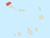
| Country | Cape Verde |
| Island | Santo Antão |
| Municipality | Paul |
| Civil parish | Santo António das Pombas |
| Population (2010)[1] | |
| • Total | 1,658 |
Janela, meaning "window" in Portuguese, is a settlement in the eastern part of the island of Santo Antão, Cape Verde. It is situated on the Atlantic coast, 4 km southeast of Pombas and 14 km northeast of the island capital Porto Novo, since 2009, it is connected with the Janela-Porto Novo Road (EN1-SA-03). The central village, Pontinha, lies on a rocky peninsula. More villages are situated in the valley of the river Ribeira da Janela, the remainder is the Águada de Janela located in the southeastern part, once contained only dirt roads, they are now connected with a paved road.
Approximately 2 km east of the village is the island's two easternmost points, Ponta do Tumbo and its lighthouse also known as Farol de Fontes Pereira de Melo, it is rarely or no longer active since 2006, another one further south is the island's easternmost point. In 2010, the Janela windmills were built.
Not far from Janela, a river bed features the Pedra Scrivida (or Pedra Escrivida), the Scrivida Stone, described by Gavin Menzies in the controversial book 1421: The Year China Discovered the World
The nation's most notable resident was Antoninho Travadinha (commonly known as Travadinha) who was one of the most autodidactic musicians of the nation.
The village's football (soccer) club is União Desportivo Janela (UD Janela) which currently plays in the Northern Santo Antão Premier Division.
See also
References
- ↑ "2010 Census results". Instituto Nacional de Estatística Cabo Verde (in Portuguese). 17 March 2014.
External links
Subdivisions of the island of Santo Antão | |||||||||||||||
|---|---|---|---|---|---|---|---|---|---|---|---|---|---|---|---|
| Paul |
|  | |||||||||||||
| Porto Novo | |||||||||||||||
| Ribeira Grande | |||||||||||||||
| Parish |  | |
|---|---|---|
| Communities and settlements | ||
| Geographical features |
| |
| Landmarks and points of Interests | ||
| Culture | ||