Kampen, Overijssel
| Kampen | |||
|---|---|---|---|
| Municipality | |||
|
Kampen city centre with the Bovenkerk in the centre | |||
| |||
.svg.png) Location in Overijssel | |||
| Coordinates: 52°33′N 5°55′E / 52.550°N 5.917°ECoordinates: 52°33′N 5°55′E / 52.550°N 5.917°E | |||
| Country | Netherlands | ||
| Province | Overijssel | ||
| Government[1] | |||
| • Body | Municipal council | ||
| • Mayor | Bort Koelewijn (CU) | ||
| Area[2] | |||
| • Total | 161.79 km2 (62.47 sq mi) | ||
| • Land | 142.64 km2 (55.07 sq mi) | ||
| • Water | 19.15 km2 (7.39 sq mi) | ||
| Elevation[3] | 1 m (3 ft) | ||
| Population (May 2014)[4] | |||
| • Total | 51,278 | ||
| • Density | 359/km2 (930/sq mi) | ||
| Demonym(s) | Kampenaar, Kamper | ||
| Time zone | CET (UTC+1) | ||
| • Summer (DST) | CEST (UTC+2) | ||
| Postcode | 8260–8279 | ||
| Area code | 038 | ||
| Website |
www | ||


Kampen (Dutch pronunciation: [ˈkɑmpən]) is a municipality, a city and an old Hanseatic city at the lower reaches of the river IJssel in the Dutch province of Overijssel.
The municipality of Kampen had a population of 51,278 in 2014 and covers an area of 161.79 square kilometres (62.47 square miles). Kampen is located in the North West of Overijssel and is the largest city in this region. The city of Kampen itself has around 35,000 inhabitants.
Kampen has one of the best preserved old town centres of the Netherlands, including remains of the ancient city wall (of which three gates are still standing) and numerous churches. Also notable are the three bridges over the IJssel which connect Kampen with IJsselmuiden and Kampereiland, the agricultural area between the branches which form the IJssel delta, and a windmill (d' Olde Zwarver – the Old Vagabond).
Traditionally people in Kampen speak a variation of the Sallands dialect, known as Kampers.
History
Middle Ages
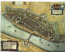
By 1150, there were already wooden buildings on the site where Kampen is currently located. The name Kampen, however, is not mentioned until 1277. The city has had city rights since 1236. As a result of its convenient location on the busy trade route between the Zuiderzee and the Rhine, Kampen quickly developed from simple settlements into a prosperous trading town, to become one of the most powerful and leading cities of northwestern Europe. In the 14th century, Kampen exchanged with the bishop of Utrecht, Jan van Arkel, the Mastenbroek polder against the right to increase the IJsseldelta.
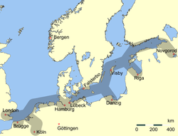
The silting up of the IJssel brought a gradual end to the prosperity of Kampen from 1430 on. For a long time Kampen did not want to sign a union and make economic and political concessions to other cities, as was usual in the Hanseatic League. When the County of Holland went to war with the Hanseatic League this situation came to an end: the city was forced to choose a side in the war. Kampen was originally more oriented toward the Baltic trade and commerce with the hinterland of the Rhine, and therefore in 1441 formally joined the Hanseatic League. The city had much influence in the League; despite loud protests from the other towns in lower reaches of the IJssel and from other Hanseatic cities, the League agreed in 1448 to build a bridge over the river.[5] This project was accomplished in just five months. With this bridge Kampen hoped to be able to develop closer relationships with the hinterland.
Post-Medieval

On 11 August 1572 Kampen was conquered from the Spaniards by Willem van den Bergh, a brother of William of Orange. After the massacre of Zutphen on 15 November, the city voluntarily surrendered to the Spanish. In 1578, the city changed ownership again after the Siege of Kampen, led by George van Lalaing. Due to its right to increase the IJsseldelta, Kampen was owner of the growing Kampereiland. From 1500 the islands were leased. The rents were so large that the city did not need to raise taxes.
The Franco-Dutch War, fought by the Republic of the United Netherlands against the Kingdom of France, Sweden, the Bishopric of Münster, the Archbishopric of Cologne and the Kingdom of England, marked a definitive end to the enormous power of the city.
Kampen only became well known again in the 19th century. The city was difficult to reach from the sea, because the surrounding wetlands became silted up and shallow. During the preceding centuries, the watercourse of the river IJssel was dredged several times, but the costs were relatively high and within a few years, the river silted up again. As the IJssel had several delta-like mouths here, the main route of the river shifted several times. In the 19th century, a new strategy was put in place to counter this problem: some watercourses were dammed to allow for more water at a higher speed through one or two main routes. This had the advantage that less sand and silt were deposited and resulted in a river course that "swept itself clean". A key figure in this story is city architect Nicolaas Plomp, who, besides his work for the current IJssel front of the city of Kampen, was also involved in hydraulic engineering. Due to the emerging industry in the 19th century and the importance of roads and railways for the economy, highways and paved roads were constructed to replace transportation over sand and mud roads.
Geography

Kampen is part of the province of Overijssel ('Over-IJssel' i.e. (mostly) across the river IJssel, as seen from the perspective of the bishopric of Utrecht by which it was held until 1528) in the Eastern part of The Netherlands, situated between the provinces of Gelderland, Flevoland, Drenthe and Friesland.
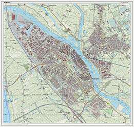
The city of Kampen is situated at the mouth of the riverIJssel. Opposite Kampen, along the IJssel, lies IJsselmuiden, which is the second largest residential nucleus of the municipality Kampen.
The municipality of Kampen has five other population centers: Grafhorst, 's-Heerenbroek, Kamperveen, Wilsum and Zalk.
Culture
Historical buildings and other landmarks

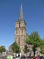
Kampen has a large number of old to very old buildings, including remains of the ancient city wall (whose city gates are still standing) and the Church of St Nicholas (Bovenkerk). The structure of the walled fortress city is still visible in the streets.
Significant structures include:
- The Koornmarktpoort: a city gate located near the river IJssel which probably dates from the 14th century. In the 15th century two squat towers were added at the outer corners.
- The Broederpoort: a rectangular city gate with four slender towers, originally from 1465, rebuilt in Renaissance style in 1615
- The Cellebroederspoort: a rectangular city gate, flanked by two heavy round towers, originally from 1465, rebuilt in 1617 in Renaissance style
- The Stedelijk Museum Kampen: located in the former town hall of Kampen, which dates from the late 14th century
- The Gotisch huis: built around 1500. This was the location of the Stedelijk Museum Kampen before it moved to its current location in the old town hall.
- The Nieuwe Toren: a tower with a carillon designed by Philips Vingboons and dating from 1648–1664
- The Church of St. Nicholas (Bovenkerk): a great Gothic basilica dating from the 14th and 15th centuries. The interior of the church houses an early-Renaissance choir screen (1552), a stone pulpit (circa 1500) and a monumental organ from 1670–1676.
- The Broederkerk: a 14th-century church which originally belonged to a Franciscan monastery
- The Buitenkerk: a 14th-century church
- The Burgwalkerk: a neoclassical 19th-century church
- A windmill called d'Olde Zwarver, built in 1842
- A monastery gate dating from 1165 called Linnenweverspoortje
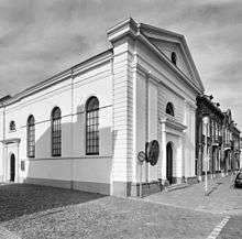
- The city auditorium (Stadsgehoorzaal), dating from 1891
- An old tobacco factory, De Olifant, where cigars are still made with 19th-century equipment. De Olifant cigars are sold in the shop and guided tours are available.
Throughout the town of Kampen, there are colorful murals which are in fact old commercials for now-defunct business in Kampen. These murals, which include Art Nouveau influences, were made by local artists and are now referred to as "frescoes of the middle class". As a result of current municipal policy, wherever these murals are discovered under old plaster, they are restored to their former glory.
A number of better or lesser known people with a certain connection with Kampen is honoured with a commemorative stone bearing their name and a single-sentence characterization of their personality or achievements, incorporated into the pavement of the Oude Raadhuisplein (formerly Koeplein), the square in between the old town hall, the former Post Office and Nieuwe Toren.
Festivals and events
An annual festival during the summer months is the Kamper ui(t) day. The name is derived from a series of folk tales in which the inhabitants of Kampen were portrayed as stupid. Another summer event is the Full Color Festival, which is organized annually. Every third Saturday of August, a comics event, called the Kamper Stripspektakel, is organized with over 100 booths.
Once every three years Sail Kampen takes place, a sailing spectacle with (old) sailing ships.
A weekend before Christmas Christmas in Oud Kampen is organized. There is street theater, where pieces of famous musicals are played, and mid-nineteenth-century characters are walking around the city.
Sports
Kampen is the home of football team DOS Kampen and its rivals Go – Ahead Kampen, KHC Kampen, VV Kampen and IJVV.
Government
Twin towns — sister cities
Kampen is twinned with:
Transportation
The railway station Kampen links Kampen with Zwolle through a non-stop diesel service on a single track. There is an alternative railway connection with Zwolle via the Hanzelijn, which links Zwolle with Amsterdam via Dronten, Lelystad and Almere. The Hanzelijn was inaugurated by the then Queen Beatrix in December 2012. Kampen Zuid railway station was built a few kilometers south of Kampen near the junction of the national roads N50 and N764, where a new residential development is planned. Somewhat confusingly there has been a Kampen Zuid railway station in existence before, between 1 October 1913 and 15 May 1934. This was the terminus of the Kampen – Hattem railway line, which connected with the Zwolle – Apeldoorn service via Wapenveld and Heerde. Regular passenger services on this line ceased in 1950. Other roads connecting the city include N760, N763, N765 and N307.
Education
Kampen has two theological universities: the Theological University of the Protestant Church in the Netherlands (PThU) and the theological college of the Reformed Church of the Netherlands (TUK).
Notable residents
- Hendrick Avercamp (Amsterdam, 1585 – Kampen, 1634), nicknamed "de Stomme van Kampen" (The Mute of Kampen), was a painter best known for his small winter landscapes. Thea Beckman featured him as a character in various books. In Kampen, a street (Avercampstraat), an elementary school (Avercampschool), and a grand café are named after him.
- Wiert Pauwel Berghuis (Oosterend (Littenseradeel), 25 April 1911 – Kampen, 29 December 1989) mayor of Kampen 1952–1970 and chairman of the Anti Revolutionaire Partij (ARP – Anti Revolutionary Party) political party (now defunct), also member of the Eerste Kamer (Senate (Netherlands)) for the ARP.
- Gerhard "Gait" Lambertus Berk (Kampen, 1927 – 17 April 2006) writer and film maker. Themes in his books and films are water, boats (especially the North-Overijssel punt (punter) and trees. He collaborated with the Dutch film maker Bert Haanstra during the making of De zaak M.P.. He was one of Ida Gerhardt's pupils at the Gemeentelijk Lyceum and continued his contacts with her until her death in 1997.
- Ida Gerhardt (Gorinchem, 11 May 1905 – Warnsveld, 15 August 1997) Dutch poet and classicist. Taught Greek and Latin at the Gemeentelijk Lyceum Grammar School from 1940 until 1951. Her pupils included the actor Henk van Ulsen and the writer / film maker Gait L. Berk.[6]
- Gerard Hengeveld (Kampen, 7 December 1910 – Bergen, 28 October 2001) Pianist, harpsichordist and composer.
- Haicke Janssen (Kampen, 1885 – London, 1915) was a sailor and World War I spy for the German naval intelligence service in England. After his arrest there by Scotland Yard, he was convicted to death. On 30 July 1915 he was executed in the Tower of London.
- Harry van der Kamp (Kampen, 1947) bass-baritone, bass-soloist, ensemble singer and initiator of 'The Sweelinck Monument' in which he directed his Gesualdo Consort in a series of recordings of the complete vocal works of the Dutch composer Jan Pieterszoon Sweelinck. He was appointed Ridder in de Orde van de Nederlandse Leeuw (Knight of the Order of the Dutch Lion) when on completion of the project the recordings were presented to Queen Beatrix of The Netherlands on October 20, 2010 in the Oude Kerk in Amsterdam.
- Dr. Willem Johan Kolff (Leiden, 14 February 1911 – Newtown Square (Pennsylvania), 11 February 2009) physician at the former municipal hospital Engelenbergstichting during World War II and pioneer of haemodialysis. A street in Kampen is named after him (Dr. Kolfflaan).[7]
- Klaas Jan Mulder (Boven-Hardinxveld, 21 mei 1930 – Kampen, 1 November 2008) Dutch organist, pianist and conductor. He was honoured with a commemorative stone on the square next to the old town hall in November 2012.[8]
- Wim Ramaker (Kampen, 1943 – 10 February 1992) Dutch broadcaster, writer and poet. Themes in his oeuvre are World War II, Kampen and his relationship and connection with his parents (his father ds. Willem Ramaker 1903 – 1943 was a Protestant church minister of the Christelijke Gereformeerde Kerken (Christian Reformed Churches) in Kampen, who died a few months after the birth of Wim).
- Klaas Schilder (Kampen, 19 December 1890 – 23 March 1952) Reformed theologian and professor in the Reformed Churches in the Netherlands (Dutch Gereformeerde Kerken in Nederland or GKN), later greatly influential in the inception and theological climate of the Reformed Churches in the Netherlands (liberated) (Dutch Gereformeerde Kerken (vrijgemaakt)).
- Adriaan C. Schuurman (Kampen, 1904 – Den Haag, 1998) influential organist, Protestant church musician and contributor of tunes to the 1973 Liedboek voor de Kerken.
- Jaap Stam (1972, Kampen), football player for Ajax Amsterdam. Also played for FC Zwolle, Cambuur Leeuwarden, Willem II, PSV Eindhoven, Manchester United, S.S. Lazio, AC Milan and the Netherlands national football team. He started playing football as a child for the local football club D.O.S. Kampen.
- Henk van Ulsen (8 May 1927, Kampen – 28 August 2009, Bussum), actor. Played in many teleplays and television series like "Dagboek van een Herdershond", "Briefgeheim", "Pension Hommeles", "Willem van Oranje" and many others.
- Petra van Staveren (1966, Kampen), swimmer who won the golden medal in the 100 metres (330 feet) breaststroke at the 1984 Summer Olympics in Los Angeles, California.
- Robert de Wilde (1977, Kampen), BMX World Champion who appeared in the 2008 Summer Olympics in Beijing.
- Jan Willem de Winter (23 March 1761, Kampen – 2 June 1812, Paris), a Dutch admiral of the Napoleonic Wars.
Image gallery
 Bovenkerk
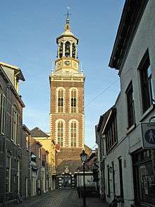 Nieuwe toren
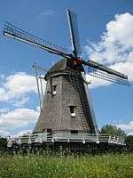 Windmill d'Olde Zwarver
 Korenmarktpoort
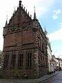 Old town hall
References
- ↑ "Burgemeester drs. mr. B. Koelewijn" (in Dutch). Gemeente Kampen. Retrieved 30 March 2014.
- ↑ "Kerncijfers wijken en buurten" [Key figures for neighbourhoods]. CBS Statline (in Dutch). CBS. 2 July 2013. Retrieved 12 March 2014.
- ↑ "Postcodetool for 8261DD". Actueel Hoogtebestand Nederland (in Dutch). Het Waterschapshuis. Retrieved 30 March 2014.
- ↑ "Bevolkingsontwikkeling; regio per maand" [Population growth; regions per month]. CBS Statline (in Dutch). CBS. 26 June 2014. Retrieved 24 July 2014.
- ↑ Kampen in fragmenten, drs. René van Mierlo, 1990, Kok.
- ↑ "Ida Gerhardt - Canon van Kampen - regiocanons.nl". regiocanons.nl.
- ↑ "Dokter Kolff - Canon van Kampen - regiocanons.nl". regiocanons.nl.
- ↑ "Herdenkingssteentje in Kampen voor musicus Klaas Jan Mulder – Muziek". Archived from the original on 22 February 2014.
External links
 Media related to Kampen, Netherlands at Wikimedia Commons
- Official website
- A view on the old city of Kampen
 |
Noordoostpolder (FL) Zwarte Meer |
| ||
| Dronten (FL) | |
Zwartewaterland Zwolle | ||
| ||||
| | ||||
| Oldebroek (GE) | Hattem (GE) |
Members of the Hanseatic League by Quarter | |||||||
|---|---|---|---|---|---|---|---|
| |||||||
| Wendish |
|  | |||||
| Saxon | |||||||
| Baltic | |||||||
| Westphalian | |||||||
| Kontore |
| ||||||
| Other cities | |||||||
Municipalities of Overijssel | ||
|---|---|---|
 | ||
| ||