Kendall, New South Wales
| Kendall New South Wales | |
|---|---|
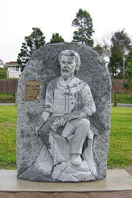
 Henry Kendall statue in a town park | |
 Kendall | |
| Coordinates | 31°38′S 152°42′E / 31.633°S 152.700°ECoordinates: 31°38′S 152°42′E / 31.633°S 152.700°E |
| Population | 833 (2011 census)[1] |
| Postcode(s) | 2439 |
| Location | 36 km (22 mi) from Port Macquarie |
| LGA(s) | Port Macquarie-Hastings Council |
| State electorate(s) | Port Macquarie |
| Federal Division(s) | Lyne |
Kendall is a town on the Mid North Coast of New South Wales, Australia.
History
Kendall was originally named Camden Heads, as it is located on the Camden Haven River.[2] It was renamed Kendall, in 1891, after the Australian poet Henry Kendall, and not, as some tourists suspect, after the similarly-spelled ancient town of Kendal in the County of Cumbria in England. Henry Kendall lived in the area from 1875 to 1881 when he was the first Forest Inspector for New South Wales.
The original residents of the Kendall area were the Birpai people.
Kendall is located 3 kilometres from Kew and 36 kilometres southwest of Port Macquarie via the Pacific Highway. It's one of seven villages that make up the Camden Haven region of the Port Macquarie/Hastings Local Government Area. At the 2011 census, it had a population of 833 people.[1]
- Middle Brother State Forest, located on the slopes of Middle Brother Mountain which was named by Captain James Cook
- Poet's Walk
Transport
Kendall railway station is served by three XPT services daily from Sydney on the North Coast railway line.
See also
References
- 1 2 Australian Bureau of Statistics (31 October 2012). "Kendall (L) (Urban Centre/Locality)". 2011 Census QuickStats. Retrieved 11 April 2015.
- ↑ "Kendall". smh.com.au. 2004-02-08. Retrieved 2009-10-02.
External links
- Kendall Village Community Home Page Accessed: 2007-09-12
