Nowendoc River
| Nowendoc River | |
| Peel Creek[1] | |
| Perennial river | |
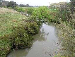 Nowendoc River, 2011 | |
| Country | Australia |
|---|---|
| State | New South Wales |
| IBRA | New England Tablelands, NSW North Coast |
| Districts | Northern Tablelands, Mid North Coast |
| Local government areas | Greater Taree |
| Part of | Manning River catchment |
| Tributaries | |
| - left | Cooplacurripa River, Rowleys River |
| Town | Nowendoc |
| Source | Great Dividing Range |
| - location | below the Black Sugarloaf, south of Walcha |
| - elevation | 1,150 m (3,773 ft) |
| Mouth | confluence with the Manning River |
| - location | near Knorrit Flat, west of Wingham |
| - elevation | 52 m (171 ft) |
| Length | 115 km (71 mi) |
| National park | Nowendoc National Park |
| Waterfall | Nowendoc Falls |
| [2] | |
Nowendoc River, a perennial river of the Manning River catchment, is located in the Northern Tablelands and Mid North Coast districts of New South Wales, Australia.
Course and features
Nowendoc River rises on the eastern slopes of the Great Dividing Range, north of the Black Sugarloaf, south of Walcha and flows generally southeast, joined by two tributaries including Cooplacurripa River and Rowleys River, before reaching its confluence with the Manning River, west of Wingham. The river descends 1,100 metres (3,600 ft) over its 115 kilometres (71 mi) course.[2]
See also
References
- ↑ "Nowendoc River". Geographical Names Register (GNR) of NSW. Geographical Names Board of New South Wales. Retrieved 15 March 2013.
- 1 2 "Map of Nowendoc River, NSW". Bonzle Digital Atlas of Australia. Retrieved 15 March 2013.
External links
- "Manning River catchments" (map). Office of Environment and Heritage. Government of New South Wales.
River systems and rivers of Hunter-Central Rivers catchment, New South Wales, Australia | |||||||
|---|---|---|---|---|---|---|---|
| |||||||
| |||||||
| |||||||
|
Coordinates: 31°45′S 152°04′E / 31.750°S 152.067°E
This article is issued from Wikipedia - version of the 5/3/2016. The text is available under the Creative Commons Attribution/Share Alike but additional terms may apply for the media files.