Ketchikan Gateway Borough, Alaska
| Ketchikan Gateway Borough, Alaska | |
|---|---|
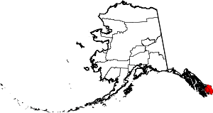 Location in the U.S. state of Alaska | |
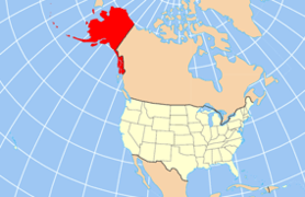 Alaska's location in the U.S. | |
| Incorporated | September 6, 1963[1] |
| Seat | Ketchikan |
| Largest city | Ketchikan |
| Area | |
| • Total | 6,654 sq mi (17,234 km2) |
| • Land | 4,858 sq mi (12,582 km2) |
| • Water | 1,795 sq mi (4,649 km2), 27.0% |
| Population (est.) | |
| • (2015) | 13,709 |
| • Density | 2.8/sq mi (1/km²) |
| Congressional district | At-large |
| Time zone | Alaska: UTC-9/-8 |
| Website |
www |
Ketchikan Gateway Borough is a borough located in the U.S. state of Alaska. As of the 2010 census, the population was 13,477.[2] The borough seat is Ketchikan.[3]
Ketchikan Gateway Borough comprises the Ketchikan, AK Micropolitan Statistical Area.
Geography
The borough has a total area of 6,654 square miles (17,230 km2), of which 4,858 square miles (12,580 km2) is land and 1,795 square miles (4,650 km2) (27.0%) is water.[4] On May 19, 2008[5] a large part of the former Prince of Wales-Outer Ketchikan Census Area was annexed, including the remainder of Misty Fjords National Monument that was not already in the borough, making the current figures much larger than these. A map of the current area can be seen here:[6]
Adjacent boroughs and census areas
- Prince of Wales-Hyder Census Area, Alaska - east and west
- City and Borough of Wrangell, Alaska - north
- Kitimat-Stikine Regional District, British Columbia - east
- Skeena-Queen Charlotte Regional District, British Columbia - south
National protected areas
- Tongass National Forest (part)
- Misty Fjords National Monument
- Misty Fjords National Monument Wilderness
- Misty Fjords National Monument
Demographics
| Historical population | |||
|---|---|---|---|
| Census | Pop. | %± | |
| 1960 | 10,070 | — | |
| 1970 | 10,041 | −0.3% | |
| 1980 | 11,316 | 12.7% | |
| 1990 | 13,828 | 22.2% | |
| 2000 | 14,070 | 1.8% | |
| 2010 | 13,477 | −4.2% | |
| Est. 2015 | 13,709 | [7] | 1.7% |
| U.S. Decennial Census[8] 1790-1960[9] 1900-1990[10] 1990-2000[11] 2010-2015[2] | |||
According to the 2010 census, there were 13,477 people, 5,305 households, and 3,369 families residing in the borough. The population density was 11 people per square mile (4/km²). There were 6,166 housing units at an average density of 5 per square mile (2/km²). The racial makeup of the borough was 68.7% White, 0.7% Black or African American, 14.3% Native American, 7.1% Asian (5.8% Filipino, 0.3% Chinese, 0.2% Japanese), 0.2% Pacific Islander (0.1% Hawaiian), 0.7% from other races, and 8.3% from two or more races. 4.3% of the population were Hispanic or Latino of any race.[12] 3.31% reported speaking Tagalog at home, while 1.65% speak Spanish .
The median income for a household in the city was $61,695 and the median income for a family was $45,417. Males had a median income of $35,139 versus $37,500 for females. The per capita income for the city was $29,520. About 8.3% of the population were below the poverty line.[13]
In 2000, there were 5,399 households out of which 36.80% had children under the age of 18 living with them, 51.50% were married couples living together, 11.30% had a female householder with no husband present, and 32.70% were non-families. 26.10% of all households were made up of individuals and 6.20% had someone living alone who was 65 years of age or older. The average household size was 2.56 and the average family size was 3.10.
In the borough the population was spread out with 28.20% under the age of 18, 7.50% from 18 to 24, 31.40% from 25 to 44, 25.10% from 45 to 64, and 7.90% who were 65 years of age or older. The median age was 36 years. For every 100 females there were 104.50 males. For every 100 females age 18 and over, there were 105.30 males.
Communities
See also
- Ketchikan Gateway Borough School District
- List of airports in the Ketchikan Gateway Borough
- National Register of Historic Places listings in Ketchikan Gateway Borough, Alaska
References
- ↑ 1996 Alaska Municipal Officials Directory. Juneau: Alaska Municipal League/Alaska Department of Community and Regional Affairs. January 1996. p. 9.
- 1 2 "State & County QuickFacts". United States Census Bureau. Retrieved May 17, 2014.
- ↑ "Find a County". National Association of Counties. Retrieved 2011-06-07.
- ↑ "US Gazetteer files: 2010, 2000, and 1990". United States Census Bureau. 2011-02-12. Retrieved 2011-04-23.
- ↑ Ketchikan Gateway Borough Service Areas & Facilities (PDF) (Map). 1:31681. Ketchikan Gateway Borough GIS Department. 2012-01-16. § "Area". Retrieved 2012-05-04.
- ↑ Map: Ketchikan Gateway Borough, Alaska Department of Labor
- ↑ "County Totals Dataset: Population, Population Change and Estimated Components of Population Change: April 1, 2010 to July 1, 2015". Retrieved July 2, 2016.
- ↑ "U.S. Decennial Census". United States Census Bureau. Retrieved May 17, 2014.
- ↑ "Historical Census Browser". University of Virginia Library. Retrieved May 17, 2014.
- ↑ "Population of Counties by Decennial Census: 1900 to 1990". United States Census Bureau. Retrieved May 17, 2014.
- ↑ "Census 2000 PHC-T-4. Ranking Tables for Counties: 1990 and 2000" (PDF). United States Census Bureau. Retrieved May 17, 2014.
- ↑ Data Access and Dissemination Systems (DADS). "American FactFinder - Results". census.gov.
- ↑ "Ketchikan Gateway Borough QuickFacts from the US Census Bureau". census.gov.
External links
- Ketchikan Gateway Borough official website
- Borough map, 2000 census: Alaska Department of Labor
- Borough map, 2010 census: Alaska Department of Labor
- Ketchikan Gateway Borough School District official website
- City of Ketchikan official website
- Conservation in Ketchikan
Municipalities and communities of Ketchikan Gateway Borough, Alaska, United States | ||
|---|---|---|
| Cities | | |
| CDPs | ||
| Unincorporated community | ||
| Ghost towns | ||
Hyder is an exclave of the Ketchikan Gateway Borough and is located in the Prince of Wales–Hyder Census Area. | ||
Juneau (capital) | ||
| Topics |
|  |
| Society |
| |
| Regions | ||
| Largest cities | ||
| Boroughs | ||
| Census Areas | ||
Coordinates: 55°33′N 131°05′W / 55.550°N 131.083°W