Kihō, Mie
| Kihō 紀宝町 | |||
|---|---|---|---|
| Town | |||
|
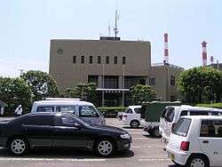
Kihō Town Office | |||
| |||
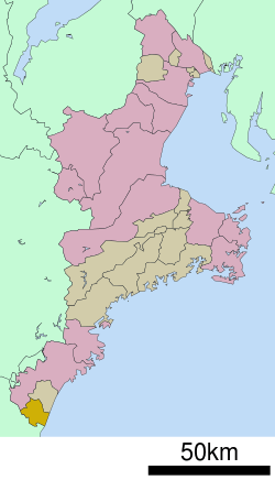 Location of Kihō in Mie Prefecture | |||
 Kihō
| |||
| Coordinates: 33°44′N 136°0′E / 33.733°N 136.000°ECoordinates: 33°44′N 136°0′E / 33.733°N 136.000°E | |||
| Country | Japan | ||
| Region | Kansai | ||
| Prefecture | Mie Prefecture | ||
| District | Minamimuro | ||
| Area | |||
| • Total | 79.66 km2 (30.76 sq mi) | ||
| Population (September 2012) | |||
| • Total | 11,454 | ||
| • Density | 144/km2 (370/sq mi) | ||
| Time zone | Japan Standard Time (UTC+9) | ||
| - Tree | Quercus | ||
| - Flower | Cymbidium kanran, Narcissus | ||
| Phone number | 0735-33-0333 | ||
| Address | 324 Minami-Udono, Kihō-chō, Minamimuro-gun, Mie-ken 519-5701 | ||
| Website |
www | ||


Kihō (紀宝町 Kihō-chō) is a town located in Mie Prefecture, Japan. As of September 2012, the town had an estimated population of 11,454 and a population density of 144 persons per km². The total area was 79.66 km².
Geography
Kihō is located near the southern tip of the Kii Peninsula, facing the Pacific Ocean, and is at the extreme southern point of Mie Prefecture, bordering on Wakayama Prefecture. Parts of the town are within the limits of the Yoshino-Kumano National Park.
Neighboring municipalities
History
The town of Kihō was established on October 31, 1951 by the merger of the villages of Ida, Mifune, and Onodani. On January 10, 2006 the village of Udono also from Minamimuro District was merged into Kihō.
Economy
Kihō serves as a commercial center for the surrounding region. Hokuetsu Paper Mills is a major industrial employer.
Transportation
Railway
Highway
Local attractions
A portion of the Sacred Sites and Pilgrimage Routes in the Kii Mountain Range, a UNESCO World Heritage Site is located within Kihō.
External links
![]() Media related to Kihō, Mie at Wikimedia Commons
Media related to Kihō, Mie at Wikimedia Commons
- Kihō official website (Japanese)
| Special city | ||
|---|---|---|
| Cities | ||
| Kuwana District | ||
| Inabe District | ||
| Mie District | ||
| Taki District | ||
| Watarai District | ||
| Kitamuro District | ||
| Minamimuro District | ||