Kitaseta District, Gunma
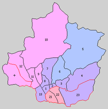
Historic Map of Tone District in 1889:
1. Numata, 2. Tonami, 3. Shirasawa, 4. Azuma, 5. Katashina, 6. Kawaba, 7. Ikeda, 8. Usune, 9. Komemaki, 10. Minakami, 11.Momono, 12.Yunohara, 13. Kawata, 21. Kuroho, 22. Itonose, 23. Akagine, +. Kuga
Areas 21, 22 and 23 were Kitaseta District
1. Numata, 2. Tonami, 3. Shirasawa, 4. Azuma, 5. Katashina, 6. Kawaba, 7. Ikeda, 8. Usune, 9. Komemaki, 10. Minakami, 11.Momono, 12.Yunohara, 13. Kawata, 21. Kuroho, 22. Itonose, 23. Akagine, +. Kuga
Areas 21, 22 and 23 were Kitaseta District
Kitaseta District (北勢多郡 Kitaseta-gun) was formerly a rural district located in Gunma Prefecture, Japan. The district is now divided between the city of Numata and the village of Shōwa.
Kitaseta District was created on December 7, 1878 with the reorganization of Gunma Prefecture into districts. It included nine villages, which were formerly part of the tenryō holdings of the Tokugawa shogunate in Kōzuke Province, three villages under the control of Maebashi Domain and three villages under joint control. With the establishment of the municipalities system on April 1, 1889 the area was organized into three villages (Kuroho, Itonose, Akagine).
On April 1, 1896, the district was merged with Tone District.
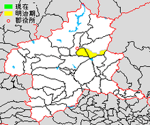
Location of Kitaseta District within Gunma Prefecture
| Core cities | ||
|---|---|---|
| Special cities | ||
| Cities | ||
| Agatsuma District | ||
| Kanra District | ||
| Kitagunma District | ||
| Ōra District | ||
| Sawa District | ||
| Tano District | ||
| Tone District | ||
This article is issued from Wikipedia - version of the 5/5/2015. The text is available under the Creative Commons Attribution/Share Alike but additional terms may apply for the media files.