Ōra, Gunma
| Ōra 邑楽町 | |||
|---|---|---|---|
| Town | |||
|
Ōra town hall | |||
| |||
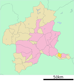 Location of Ōra in Gunma Prefecture | |||
 Ōra
| |||
| Coordinates: 36°15′8.6″N 139°27′44.3″E / 36.252389°N 139.462306°ECoordinates: 36°15′8.6″N 139°27′44.3″E / 36.252389°N 139.462306°E | |||
| Country | Japan | ||
| Region | Kantō | ||
| Prefecture | Gunma Prefecture | ||
| District | Ōra | ||
| Area | |||
| • Total | 31.11 km2 (12.01 sq mi) | ||
| Population (February 2015) | |||
| • Total | 26,380 | ||
| • Density | 848/km2 (2,200/sq mi) | ||
| Time zone | Japan Standard Time (UTC+9) | ||
| - Tree | Pinus densiflora | ||
| - Flower | Azalea | ||
| Phone number | 0276-88-5511 | ||
| Address | 3040 Ōaza Nakano, Ōra-machi, Gunma-ken 370-0692 | ||
| Website | Official website | ||


Ōra (邑楽町 Ōra-machi) is a town located in Ōra District, Gunma Prefecture, in the northern Kantō region of Japan. As of February 2015, the town had an estimated population of 26,380 and a population density of 848 persons per km². Its total area was 31.11 km².
Geography
Ōra is located in the extreme southern corner Gunma prefecture, bordered by Tochigi Prefecture to the north.
Surrounding municipalities
History
The villages of Nakano, Takashima and Nagae were created within Ōra District, Gunma Prefecture on April 1, 1889 with the creation of the municipalities system after the Meiji Restoration. On March 1, 1955, Nakano and Takashima merged to form the village of Nakajima. Nakae merged with neighboring Tominaga and Eiraku to form the village of Chiyoda. However, on September 30, 1956 the former Nakae village was transferred from Chiyoda to Nakajima, and Nakajma was renamed Ōra on January 1, 1957. Ōra was elevated to town status on April 1, 1968.
Education
- Primary Schools
- Nakano Elementary School
- Nakanohigashi Elementary School
- Takashima Elementary School
- Nagara Elementary School
- Middle Schools
- Ōra Middle School
- Ōraminami Middle School
Transportation
Railway
Highway
Local attractions
- Ōra Symbol Tower
- Matsumoto Park
- Tatara Marshland
External links
![]() Media related to Ōra, Gunma at Wikimedia Commons
Media related to Ōra, Gunma at Wikimedia Commons
- Official website (Japanese)
| Core cities | ||
|---|---|---|
| Special cities | ||
| Cities | ||
| Agatsuma District | ||
| Kanra District | ||
| Kitagunma District | ||
| Ōra District | ||
| Sawa District | ||
| Tano District | ||
| Tone District | ||